Iron Belt, Wisconsin facts for kids
Quick facts for kids
Iron Belt, Wisconsin
|
|
|---|---|

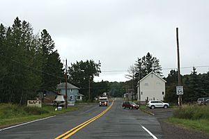
Looking east at downtown Iron Belt on WIS77
|
|

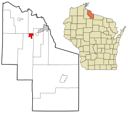
Location in Iron County and the state of Wisconsin.
|
|
| Country | United States |
| State | Wisconsin |
| County | Iron |
| Town | Knight |
| Area | |
| • Total | 2.451 sq mi (6.35 km2) |
| • Land | 2.451 sq mi (6.35 km2) |
| • Water | 0 sq mi (0 km2) |
| Elevation | 1,555 ft (474 m) |
| Population
(2020)
|
|
| • Total | 158 |
| • Density | 64.46/sq mi (24.89/km2) |
| Time zone | UTC-6 (Central (CST)) |
| • Summer (DST) | UTC-5 (CDT) |
| ZIP code |
54536
|
| Area code(s) | 715 & 534 |
| GNIS feature ID | 1566963 |
Iron Belt is a small community located in Iron County, Wisconsin, United States. It is known as an unincorporated community, which means it's a place with a shared identity but without its own local government like a city or town. It's also a census-designated place, meaning the U.S. Census Bureau counts its population separately.
Iron Belt is found along Wisconsin Highway 77, southwest of a place called Montreal. It's part of the larger area known as the town of Knight. Even though it's small, Iron Belt has its own post office with the ZIP code 54536. In 2020, about 158 people lived there.
A Special Person from Iron Belt
Iron Belt is famous for being the birthplace of Karl Emil Nygard. He holds a unique place in American history.
Who Was Karl Emil Nygard?
Karl Emil Nygard was the first and only mayor in U.S. history who was a Communist. A Communist is someone who believes in a political and economic idea called communism. This idea suggests that all property and resources should be owned by the community as a whole, rather than by individuals. Nygard served as the mayor of a city in Minnesota. His story shows how different political ideas have been part of American history.
See also
 In Spanish: Iron Belt (Wisconsin) para niños
 | Isaac Myers |
 | D. Hamilton Jackson |
 | A. Philip Randolph |


