
Upson, Wisconsin facts for kids
Quick facts for kids
Upson, Wisconsin
|
|
|---|---|

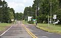
Looking east in Upson on WIS77
|
|

Upson, Wisconsin
Location in Wisconsin

Upson, Wisconsin
Location in the United States
|
|
| Country | |
| State | |
| County | Iron |
| Town | Anderson |
| Elevation | 454 m (1,489 ft) |
| Time zone | UTC-6 (Central (CST)) |
| • Summer (DST) | UTC-5 (CDT) |
| ZIP code |
54565
|
| Area code(s) | 715 & 534 |
| GNIS feature ID | 1576004 |
Upson is a small, unincorporated community located in Iron County, Wisconsin, United States. An "unincorporated community" means it's a group of homes and businesses that isn't officially a city or town with its own local government. Upson is found where two main roads meet: Wisconsin Highway 77 and Wisconsin Highway 122. It's about 12 miles (19 km) southwest of a larger town called Hurley. Upson is part of the larger area known as the town of Anderson.
About Upson
Upson is a quiet place in northern Wisconsin. It's known for its natural beauty and outdoor activities. The community is named after one of the three people who first surveyed the land.
A Look Back in Time
Years ago, Upson was home to an Air Defense Command radar station. This station was part of a network called the Permanent System radar network. Its job was to detect airplanes and other objects in the sky. Think of it like a giant eye watching over the area. The station was known as P-16B. Upson also used to have its own post office, but it closed down on March 16, 1985.
Images for kids
-
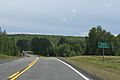
Looking north at Upson from the southern end of WIS122
-
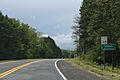
Looking east at the sign for Upson on WIS77
-
Looking west at the sign for Upson on WIS77


