Rusk County, Wisconsin facts for kids
Quick facts for kids
Rusk County
|
|
|---|---|

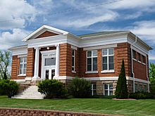
Ladysmith Carnegie Library, designed by Claude and Starck. It is now operated as a bed and breakfast inn.
|
|

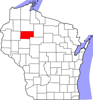
Location within the U.S. state of Wisconsin
|
|
 Wisconsin's location within the U.S. |
|
| Country | |
| State | |
| Founded | 1901 |
| Named for | Jeremiah McLain Rusk |
| Seat | Ladysmith |
| Largest city | Ladysmith |
| Area | |
| • Total | 931 sq mi (2,410 km2) |
| • Land | 914 sq mi (2,370 km2) |
| • Water | 17 sq mi (40 km2) 1.9%% |
| Population
(2020)
|
|
| • Total | 14,188 |
| • Estimate
(2023)
|
14,143 |
| • Density | 15.5/sq mi (6.0/km2) |
| Time zone | UTC−6 (Central) |
| • Summer (DST) | UTC−5 (CDT) |
| Congressional district | 7th |
Rusk County is a place in Wisconsin, a state in the United States. In 2020, about 14,188 people lived here. The main town, called the county seat, is Ladysmith. Two important rivers, the Chippewa and Flambeau, flow through the county. You can find many things here, from farms and lakes with vacation homes to hiking trails in the Blue Hills.
Contents
Exploring Rusk County's Past
The forests of Rusk County were once home to different Native American groups. Some traveled through using the rivers, while others camped or buried their dead here.
Early European Visitors
The first Europeans known to visit were Father Louis Hennepin and his group in 1680. They traveled by canoe up the Chippewa River. At that time, this area was part of New France. Later, in 1790, Lakota warriors came up the Chippewa River to fight the Ojibwe. The Ojibwe won, keeping control during the fur trade era.
The first European-American settlers and loggers arrived by traveling up the Chippewa River. They came from the south, entering what is now Rusk County near modern Holcombe. This is where the Flambeau River joins the Chippewa. An Native American village was located on the bank of the Chippewa River. European-American settlement began near this village in 1847.
Logging and Rivers
In the early days, loggers cut down pine trees in winter. Then, they would float huge amounts of logs down the rivers to sawmills. These sawmills were in towns like Chippewa Falls and Eau Claire. This was done during the spring and early summer floods.
At first, supplies were moved up the rivers using boats. Later, "tote roads" were built. These roads allowed loggers to haul supplies with oxen and horses to their remote logging camps. One of these early roads was the Chippewa Trail. It followed the Chippewa River from the south to the north end of the county. By 1880, this trail became a stage road. A horse-drawn stagecoach would travel up one day and back down the next. There were stopping places, like inns, every five miles for loggers to rest.
Railroads Arrive
Railroads came to the area in 1884. The Mississippi River Logging Company brought in a train to start a logging railroad. Another company, led by Weyerhaueser, also built tracks. They used trains to move logs to Big Bend, where the logs were then put into the Chippewa River. This railroad, called the Chippewa River and Menomonie Railroad, later moved its operations north of Bruce.
In the same year, the Minneapolis, St. Paul and Sault Ste. Marie Railroad (called the Soo Line) began building its railroad across the area. It aimed to connect cities like Minneapolis with shipping at Sault Ste. Marie. The two railroads met at a place called Apollonia. In the 1890s, Apollonia grew to be the largest town in the area.
The Soo Line continued building east in 1884 and 1885. This led to the creation of towns like Weyerhaeuser, Bruce, Ladysmith (then called Warner), Tony (then Deer Tail), Glen Flora (then Miller's Siding), Ingram, and Hawkins. The new railroad made it easier to transport lumber to markets. This was especially helpful for moving hardwoods, which did not float as well as pine. Many of these small towns had sawmills, some with their own small logging railroads reaching into the forests.
How Rusk County Got Its Name
Rusk County was officially created in 1901. The Wisconsin government separated the northern part of what was then Chippewa County. The new county was first named Gates County. This was because a land speculator named James L. Gates promised to donate money if it was named after him. When he didn't provide the money, the state government renamed it Rusk in 1905. The county was named after Jeremiah M. Rusk, who was a governor of Wisconsin and the first U.S. Secretary of Agriculture.
Around 1905, another railroad, the Wisconsin Central Railroad, built a line through the county. This line connected Chicago's direction toward Superior. It crossed the Soo Line in Ladysmith. By 1907, passenger trains were regularly passing through. This new line helped create more small towns like Sheldon, Conrath, Crane, and Murry.
Changes in the Economy
The way people made a living in Rusk County began to change. Floating pine logs down the Chippewa River mostly ended around 1906. Cutting hardwood trees was popular from 1905 to 1915, but then it also started to decline. With less timber, people looked for new ways to make money. Some ideas, like mining and large-scale ranching, didn't work out. However, a paper mill started in Ladysmith, which was successful.
The Big Falls Dam was built around 1920 to create electricity. Other dams in the area were also changed to produce electricity later on.
Logging companies sold land that had been cut over to farmers. These farmers raised cattle and grew crops like potatoes. They slowly cleared the land to create family farms. As more land was logged, more of the county became farmland. The sawmill towns changed to serve the surrounding farms. They had stores, creameries (places that make butter and cheese), and feed mills.
The Great Depression and New Programs
During the Great Depression, times were very hard in Rusk County. Many banks and cheese factories closed. But this was also when Jump River Electric, supported by a government program called the New Deal Rural Electric Administration, brought electricity to farms and homes in the countryside.
A Civilian Conservation Corps (CCC) camp was also set up in Rusk County. This program employed young men, mostly from cities, to work on public projects. The men at the Rusk County camp fought fires, built roads, helped with fire towers, and planted trees. When the U.S. entered WWII, many CCC members joined the military, and the camp closed.
Schools in Rusk County
Rusk County's first rural schools opened around 1891. These were often one-room schools with one teacher for many grades. Ladysmith had a school by 1905. A special school, the Rusk County Normal School, opened in Ladysmith in 1907. It trained 719 teachers before it closed in 1948. At one time, Rusk County had 125 rural schools.
After the Depression, fewer people lived in rural areas, and farms became larger. Rural schools also combined. Good roads and school buses allowed students to go to larger schools in towns. Most schools were combined by 1960.
The Flambeau Mine
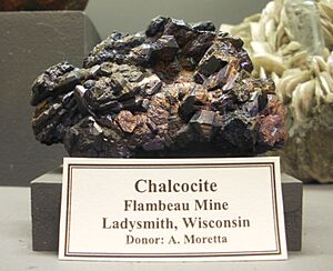
In the 1990s, the Flambeau Mine was an open pit mine near the Flambeau River, south of Ladysmith. This mine produced copper, gold, and silver. Mining so close to the river was a big discussion. An early plan was stopped, but a new, safer plan was approved in 1987.
The mine operated from 1991 to 1999. It created a pit about 2,600 feet long and 220 feet deep. It produced a lot of copper, gold, and silver. After the mining stopped, the pit was filled back in and planted with native plants. Today, it has walking trails that are open to everyone.
Over the years, many sawmills and cheese factories in smaller towns have closed. But other businesses have grown. Today, the largest employers in Rusk County include Weather Shield, Jeld-Wen, the Rusk County government, local schools, Wal-Mart, Artisans, the medical center in Ladysmith, and Rand Trucking.
Rusk County's Location
Rusk County covers about 931 square miles. Most of this area (914 square miles) is land, and 17 square miles (about 1.9%) is water.
Neighboring Counties
Rusk County shares borders with these other counties:
- Washburn County - to the northwest
- Sawyer County - to the north
- Price County - to the east
- Taylor County - to the southeast
- Chippewa County - to the south
- Barron County - to the west
Main Roads
You can travel through Rusk County on these major highways:
Railroads and Airport
- Two railroad companies operate here: Canadian National and Watco.
- The Rusk County Airport (KRCX) serves the county and nearby areas.
People of Rusk County
| Historical population | |||
|---|---|---|---|
| Census | Pop. | %± | |
| 1910 | 11,160 | — | |
| 1920 | 16,403 | 47.0% | |
| 1930 | 16,081 | −2.0% | |
| 1940 | 17,737 | 10.3% | |
| 1950 | 16,790 | −5.3% | |
| 1960 | 14,794 | −11.9% | |
| 1970 | 14,238 | −3.8% | |
| 1980 | 15,589 | 9.5% | |
| 1990 | 15,079 | −3.3% | |
| 2000 | 15,347 | 1.8% | |
| 2010 | 14,755 | −3.9% | |
| 2020 | 14,188 | −3.8% | |
| U.S. Decennial Census 1790–1960 1900–1990 1990–2000 2010 2020 |
|||
In 2020, the population of Rusk County was 14,188 people. Most people (94.2%) were White. Other groups included Native American, Asian, and Black or African American people. About 1.8% of the population was Hispanic or Latino.
Towns and Villages
Rusk County has one city, several villages, and many towns. It also has smaller communities and some "ghost towns" that are no longer inhabited.
City
- Ladysmith (This is the county seat, where the main county offices are located.)
Villages
Towns
Unincorporated Communities
- Apollonia
- Bear Lake
- Imalone
- Island Lake
- Murry
- Port Arthur
- South Fork
- Strickland
- Thornapple
Ghost Towns
- Atlanta
- Big Bend
- Crane
- Egypt
- Horseman (Varner)
- Jerome
- Kalish
- Mandowish (Manedowish)
- Poplar / Beldonville
- Pre Bram
- Shaws Farm
- Teresita
- Tibbets
- Vallee View / Walrath
- West Ingram
- Wilson Center / Dogville (Starez)
See also
 In Spanish: Condado de Rusk (Wisconsin) para niños
 | Delilah Pierce |
 | Gordon Parks |
 | Augusta Savage |
 | Charles Ethan Porter |


