Washburn County, Wisconsin facts for kids
Quick facts for kids
Washburn County
|
|
|---|---|

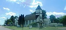
Historical Museum in Shell Lake, Wisconsin
|
|

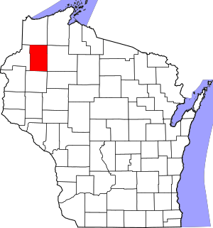
Location within the U.S. state of Wisconsin
|
|
 Wisconsin's location within the U.S. |
|
| Country | |
| State | |
| Founded | 1883 |
| Named for | Cadwallader C. Washburn |
| Seat | Shell Lake |
| Largest city | Spooner |
| Area | |
| • Total | 853 sq mi (2,210 km2) |
| • Land | 797 sq mi (2,060 km2) |
| • Water | 56 sq mi (150 km2) 6.6%% |
| Population
(2020)
|
|
| • Total | 16,623 |
| • Estimate
(2023)
|
16,930 |
| • Density | 20.9/sq mi (8.1/km2) |
| Time zone | UTC−6 (Central) |
| • Summer (DST) | UTC−5 (CDT) |
| Congressional district | 7th |
Washburn County is a county located in the state of Wisconsin in the United States. It was named after Governor Cadwallader C. Washburn. The county was created in 1883.
As of the 2020 census, about 16,623 people lived here. The main town, also called the county seat, is Shell Lake.
Contents
Exploring Washburn County's Geography
Washburn County covers a total area of about 853 square miles. Most of this area, about 797 square miles, is land. The rest, about 56 square miles, is water. This means that about 6.6% of the county is covered by water.
Main Roads in Washburn County
Several important roads help people travel through Washburn County:
 U.S. Highway 53
 U.S. Highway 63
 Highway 48 (Wisconsin)
 Highway 70 (Wisconsin)
 Highway 77 (Wisconsin)
 Highway 253 (Wisconsin)
Railroads and Travel
Trains also run through the county. Two main railroad companies are:
For air travel, the Shell Lake Municipal Airport (KSSQ) serves the county. It helps people fly in and out of the area.
Neighboring Counties
Washburn County shares its borders with several other counties:
- Douglas County to the north
- Bayfield County to the northeast
- Sawyer County to the east
- Rusk County to the southeast
- Barron County to the south
- Burnett County to the west
Protected Natural Areas
Part of the Saint Croix National Scenic Riverway is located within Washburn County. This is a special area protected for its natural beauty and rivers.
Understanding Washburn County's Population
| Historical population | |||
|---|---|---|---|
| Census | Pop. | %± | |
| 1890 | 2,926 | — | |
| 1900 | 5,521 | 88.7% | |
| 1910 | 8,196 | 48.5% | |
| 1920 | 11,377 | 38.8% | |
| 1930 | 11,103 | −2.4% | |
| 1940 | 12,496 | 12.5% | |
| 1950 | 11,665 | −6.7% | |
| 1960 | 10,301 | −11.7% | |
| 1970 | 10,601 | 2.9% | |
| 1980 | 13,174 | 24.3% | |
| 1990 | 13,772 | 4.5% | |
| 2000 | 16,036 | 16.4% | |
| 2010 | 15,911 | −0.8% | |
| 2020 | 16,623 | 4.5% | |
| U.S. Decennial Census | |||
The population of Washburn County has changed over many years. In 1890, there were about 2,926 people. By 2020, the population had grown to 16,623.
Who Lives in Washburn County?
Based on the 2020 census, the county had 16,623 residents. The population density was about 20.9 people per square mile. There were also 12,708 housing units.
Most people in the county, about 92.9%, are White. About 1.2% are Native American, and smaller percentages are Asian, Black, or Pacific Islander. About 4.8% of the population identifies with two or more races. About 1.8% of the people are of Hispanic or Latino background.
Communities in Washburn County
Washburn County has several different types of communities.
Cities
- Shell Lake (This is the county seat, where the main government offices are)
- Spooner
Villages
Towns
Census-Designated Places (CDPs)
These are areas that are like towns but are not officially incorporated as cities or villages.
- Springbrook
- Stone Lake (part)
- Trego
Other Unincorporated Communities
These are smaller communities that are not officially part of a city, village, or town.
Education in Washburn County
Several school districts serve the students in Washburn County:
- Birchwood School District
- Hayward Community School District
- Northwood School District
- Rice Lake Area School District
- Shell Lake School District
- Spooner Area School District
See also
 In Spanish: Condado de Washburn para niños
 | Bayard Rustin |
 | Jeannette Carter |
 | Jeremiah A. Brown |


