Solon Springs, Wisconsin facts for kids
Quick facts for kids
Solon Springs, Wisconsin
|
|
|---|---|

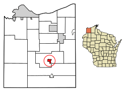
Location of the Village of Solon Springs
in Douglas County, Wisconsin |
|
| Country | |
| State | |
| County | Douglas |
| Area | |
| • Total | 2.30 sq mi (5.95 km2) |
| • Land | 1.57 sq mi (4.06 km2) |
| • Water | 0.73 sq mi (1.90 km2) |
| Elevation | 1,122 ft (342 m) |
| Population
(2020)
|
|
| • Total | 656 |
| • Density | 285.2/sq mi (110.25/km2) |
| Time zone | UTC-6 (Central (CST)) |
| • Summer (DST) | UTC-5 (CDT) |
| Area code(s) | 715 and 534 |
| FIPS code | 55-74575 |
| GNIS feature ID | 1574366 |
| Website | www.villageofsolonsprings.com |
Solon Springs is a small village located in Douglas County, Wisconsin, in the United States. In 2020, about 656 people lived there. This was a bit more than the 600 people who lived there in 2010. The village is completely surrounded by the larger area known as the Town of Solon Springs.
Contents
What's the History of Solon Springs?
Solon Springs was not always called by its current name. It was first known as White Birch. This name came from a group of white birch trees that grew near where the town was first built.
The village's current name, Solon Springs, honors a person named Thomas F. Solon. He was the one who found special mineral springs in the area. A post office was first set up in 1885 under the name White Birch. Later, in 1896, the post office's name was changed to Solon Springs.
Where is Solon Springs Located?
Solon Springs is found at these coordinates: 46°21′3″N 91°49′5″W / 46.35083°N 91.81806°W.
The United States Census Bureau says that the village covers a total area of about 2.30 square miles (5.95 square kilometers). Most of this area, about 1.57 square miles (4.06 square kilometers), is land. The rest, about 0.73 square miles (1.90 square kilometers), is water.
Solon Springs is located about 32 miles southeast of a larger city called Superior.
How Many People Live in Solon Springs?
The number of people living in Solon Springs has changed over the years. Here's a quick look at the population counts from different years:
| Historical population | |||
|---|---|---|---|
| Census | Pop. | %± | |
| 1930 | 282 | — | |
| 1940 | 392 | 39.0% | |
| 1950 | 480 | 22.4% | |
| 1960 | 530 | 10.4% | |
| 1970 | 598 | 12.8% | |
| 1980 | 590 | −1.3% | |
| 1990 | 575 | −2.5% | |
| 2000 | 576 | 0.2% | |
| 2010 | 600 | 4.2% | |
| 2020 | 656 | 9.3% | |
| U.S. Decennial Census | |||
What Was the Population Like in 2010?
In 2010, there were 600 people living in Solon Springs. These people lived in 263 households, and 168 of these were families. On average, there were about 382 people per square mile of land.
Most of the people living in the village were White (97.5%). A small number were African American (0.2%) or Native American (1.3%). About 1.0% of the people were from two or more racial backgrounds. A very small group, 0.7%, were Hispanic or Latino.
About 25.9% of the households had children under 18 living with them. Many households (50.2%) were married couples living together. The average household had 2.28 people, and the average family had 2.81 people.
The average age of people in the village was 43.1 years old. About 23.2% of residents were under 18. About 15.7% were 65 years old or older. Slightly more than half of the residents (51.5%) were female, and 48.5% were male.
How Do People Get Around in Solon Springs?
Main Roads
U.S. Highway 53 is an important road that goes through the area. However, the main part of this highway now goes around the village. The older part of the highway that is still in Solon Springs is called "Business 53."
Airport
The Solon Springs Municipal Airport (KOLG) helps people travel to and from the village and nearby communities by air.
What About Schools in Solon Springs?
The Solon Springs School District is responsible for the schools in the village and the surrounding town.
See also
 In Spanish: Solon Springs (Wisconsin) para niños
 | James B. Knighten |
 | Azellia White |
 | Willa Brown |


