Carlton County, Minnesota facts for kids
Quick facts for kids
Carlton County
|
|
|---|---|

|
|

Location within the U.S. state of Minnesota
|
|
 Minnesota's location within the U.S. |
|
| Country | |
| State | |
| Founded | May 23, 1857 (created) 1870 (organized) |
| Named for | Reuben B. Carlton |
| Seat | Carlton |
| Largest city | Cloquet |
| Area | |
| • Total | 875 sq mi (2,270 km2) |
| • Land | 861 sq mi (2,230 km2) |
| • Water | 14 sq mi (40 km2) 1.6%% |
| Population
(2020)
|
|
| • Total | 36,207 |
| • Estimate
(2023)
|
36,825 |
| • Density | 42.1/sq mi (16.3/km2) |
| Time zone | UTC−6 (Central) |
| • Summer (DST) | UTC−5 (CDT) |
| Congressional district | 8th |
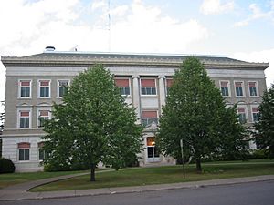
Carlton County is a county located in the state of Minnesota, United States. It was created in 1857 and officially organized in 1870. The county seat, which is like the main administrative city, is Carlton.
As of the 2020 census, about 36,207 people lived here. A part of the Fond du Lac Indian Reservation is also located in the northeastern part of Carlton County. This county is also part of the larger Duluth, MN–WI Metropolitan Statistical Area.
Contents
Geography of Carlton County
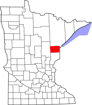
Carlton County is found on the eastern side of Minnesota. Its eastern border touches the state of Wisconsin. Several rivers flow through the county. The Saint Louis River flows east-southeast and eventually empties into Lake Superior.
The Moose Horn River flows southwest, joining the Kettle River. The Nemadji River and its South Fork also flow east. They meet close to the eastern border before reaching Lake Superior. The land in the county has gentle, rolling hills and is covered with many trees. It slopes down into the river valleys.
How Big is Carlton County?
Carlton County covers a total area of 875 square miles (2,266 square kilometers). Most of this area, 861 square miles (2,230 square kilometers), is land. The remaining 14 square miles (36 square kilometers) is water, which is about 1.6% of the total area.
Main Roads in Carlton County
Many important highways cross Carlton County, helping people travel around.
Neighboring Counties
Carlton County shares its borders with several other counties.
- Saint Louis County – to the north
- Douglas County, Wisconsin – to the east
- Pine County – to the south
- Aitkin County – to the west
Protected Natural Areas
Carlton County is home to several protected natural areas. These places help keep nature safe and offer spaces for outdoor activities.
- Black Hoof Wildlife Management Area
- Dye State Wildlife Management Area
- Fond du Lac State Forest (part)
- Jay Cooke State Park
- Kettle Lake State Wildlife Management Area
- Nemadji State Forest (part)
- Sawyer State Wildlife Management Area
History of Carlton County
Carlton County was officially formed and organized in 1870. It was named after Reuben B. Carlton, who was a member of the Minnesota Senate.
An important event in the county's history was the Cloquet fire in October 1918. This was a very large forest fire. The Carlton County Historical Society has a special exhibit about this fire. They also have exhibits about the Ojibwe people of Carlton County and the history of logging in the area.
Climate and Weather in Carlton County
| Weather chart for Carlton, Minnesota | |||||||||||||||||||||||||||||||||||||||||||||||
|---|---|---|---|---|---|---|---|---|---|---|---|---|---|---|---|---|---|---|---|---|---|---|---|---|---|---|---|---|---|---|---|---|---|---|---|---|---|---|---|---|---|---|---|---|---|---|---|
| J | F | M | A | M | J | J | A | S | O | N | D | ||||||||||||||||||||||||||||||||||||
|
1
20
1
|
0.9
27
6
|
1.5
38
17
|
2.3
54
29
|
3.2
67
39
|
4.2
75
48
|
4.2
80
54
|
4
78
53
|
4.3
68
45
|
3.1
54
34
|
2
37
22
|
Expression error: Unrecognized punctuation character "{".
<div style="overflow:hidden;background:#e44;position:absolute;left:.4em;width:0.8em;z-index:4;bottom:Expression error: Unrecognized punctuation character "{".em;height:Expression error: Unrecognized punctuation character "{".em;"> <div style="color:red;position:absolute;bottom:Expression error: Unrecognized punctuation character "{".em; left:0;width:1.5em;height:1.5em;text-align:center;z-index:4">Expression error: Unrecognized punctuation character "{". <div style="color:red;position:absolute;bottom:Expression error: Unrecognized punctuation character "{".em; left:0;width:1.5em;height:1.5em;text-align:center;z-index:4">Expression error: Unrecognized punctuation character "{". |
||||||||||||||||||||||||||||||||||||
| temperatures in °F precipitation totals in inches source: The Weather Channel |
|||||||||||||||||||||||||||||||||||||||||||||||
|
Metric conversion
<div style="color:red;position:absolute;bottom:Expression error: Unrecognized punctuation character "{".em; left:-.4em;width:1.6em;height:1.5em;text-align:right;">Expression error: Unrecognized punctuation character "{".<div style="color:red;position:absolute;bottom:Expression error: Unrecognized punctuation character "{".em; left:-.4em;width:1.6em;height:1.5em;text-align:right;">Expression error: Unrecognized punctuation character "{".
|
|||||||||||||||||||||||||||||||||||||||||||||||
The weather in Carlton County changes a lot with the seasons. In the county seat of Carlton, average temperatures in January are around 1°F (-17°C). In July, the average high temperature is about 80°F (27°C).
However, temperatures can be much more extreme. The coldest temperature ever recorded was -45°F (-43°C) in January 1912. The hottest temperature ever recorded was 105°F (41°C) in July 1936. The amount of rain and snow also varies throughout the year, with September usually being the wettest month.
Population of Carlton County
| Historical population | |||
|---|---|---|---|
| Census | Pop. | %± | |
| 1860 | 51 | — | |
| 1870 | 286 | 460.8% | |
| 1880 | 1,230 | 330.1% | |
| 1890 | 5,272 | 328.6% | |
| 1900 | 10,017 | 90.0% | |
| 1910 | 17,559 | 75.3% | |
| 1920 | 19,391 | 10.4% | |
| 1930 | 21,232 | 9.5% | |
| 1940 | 24,212 | 14.0% | |
| 1950 | 24,584 | 1.5% | |
| 1960 | 27,932 | 13.6% | |
| 1970 | 28,072 | 0.5% | |
| 1980 | 29,936 | 6.6% | |
| 1990 | 29,259 | −2.3% | |
| 2000 | 31,671 | 8.2% | |
| 2010 | 35,386 | 11.7% | |
| 2020 | 36,207 | 2.3% | |
| 2023 (est.) | 36,825 | 4.1% | |
| U.S. Decennial Census 1790-1960 1900-1990 1990-2000 2010-2020 |
|||
The population of Carlton County has grown steadily over the years. In 1860, only 51 people lived there. By 2020, the population had reached 36,207 people.
According to the 2010 census, most people in the county were White (89.7%). About 5.9% were Native American, and 1.4% were Hispanic or Latino. Many residents have German, Finnish, Norwegian, or Swedish family backgrounds.
Communities in Carlton County
Carlton County has several cities and smaller communities where people live.
Cities
These are the main cities in Carlton County:
Census-Designated Places
These are areas that are like towns but are not officially incorporated as cities:
Unincorporated Communities
These are smaller settlements that don't have their own local government:
Townships
Townships are smaller local government areas, often covering rural parts of the county:
- Atkinson Township
- Automba Township
- Barnum Township
- Beseman Township
- Blackhoof Township
- Eagle Township
- Holyoke Township
- Kalevala Township
- Lakeview Township
- Mahtowa Township
- Moose Lake Township
- Perch Lake Township
- Silver Township
- Silver Brook Township
- Skelton Township
- Split Rock Township
- Thomson Township
- Twin Lakes Township
- Wrenshall Township
Unorganized Territories
These are areas that are not part of any city or township:
- Clear Creek
- North Carlton (This includes Corona, Progress, Red Clover, and Sawyer Unorganized Townships.)
Images for kids
See also
 In Spanish: Condado de Carlton para niños
 | Misty Copeland |
 | Raven Wilkinson |
 | Debra Austin |
 | Aesha Ash |


