
Saint Louis River (Lake Superior tributary) facts for kids
Quick facts for kids Saint Louis River |
|
|---|---|

The Saint Louis River at Thomson, Minnesota
|
|

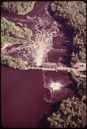
Mouth of the St. Louis River
|
|
| Native name | Gichigami-ziibi |
| Country | United States |
| State | Minnesota, Wisconsin |
| County | St. Louis and Carlton Counties, Minnesota; Douglas County, Wisconsin |
| Physical characteristics | |
| Main source | Babbitt SE 47°30′04″N 91°49′51″W / 47.5010312°N 91.8307225°W |
| River mouth | Lake Superior West Deluth 46°45′N 92°06′W / 46.75°N 92.1°W |
| Length | 192 miles (309 km) |
| Basin features | |
| Basin size | 3,634 sq mi (9,410 sq km) |
The Saint Louis River, also called the St. Louis River, is a long river in the United States. It flows through Minnesota and Wisconsin before emptying into Lake Superior. It's the biggest U.S. river that flows into Lake Superior. The river is about 192 miles (309 kilometers) long. It begins near Hoyt Lakes, Minnesota. Its watershed (the area of land that drains into it) covers about 3,634 square miles (9,410 square kilometers).
Near the cities of Duluth, Minnesota and Superior, Wisconsin, the river turns into a freshwater estuary. An estuary is where a river meets the sea, but here it's a lake. The lower part of the St. Louis River is the only place in Minnesota where you can go whitewater rafting.
Contents
River History and Exploration

The Ojibwe people have a name for this river: Gichigami-ziibi. This means "Great-lake River."
The river likely got its current name from Pierre Gaultier de Varennes, sieur de La Vérendrye. He was an active explorer in the 1730s and 1740s. The King of France gave him a special award, the Order of Saint Louis, in 1749. This was to honor his important discoveries. The river's name seems to come from this award.
Older maps from the 1600s and 1700s called it the "Rivière du Fond du Lac." This means "River of the Bottom of the Lake." The name Saint Louis River first appeared on maps around 1778.
Important Waterway for Travel
The Saint Louis River was a very important route for travel and trade. It connected the Mississippi River waterways in the west to the Great Lakes in the east.
Jay Cooke State Park is located near where the river flows into Lake Superior. This park is home to an old canoe portage trail. A portage is a path where people carry their boats over land. Native Americans, European explorers, and fur traders used this trail for centuries.
The trail was very difficult. It had steep hills and swamps. It started at the rapids near a place called Fond du Lac. From there, it climbed about 450 feet (137 meters) to the city of Carlton.
After Carlton, travelers could go upstream to Lake Vermillion and the Rainy River. Or, they could travel southwest up the East Savanna River. Then, they would carry their canoes across the tough 6-mile (9.7 km) Savanna Portage. This portage is now a state park. After that, they could paddle all the way to the Mississippi River.
River Pollution and Cleanup Efforts
By the mid-1900s, the lower Saint Louis River became one of the most polluted rivers in Minnesota. A children's book from 1941, Paddle-to-the-Sea, even showed how polluted the river was.
By 1975, the river was named an "Area of Concern" by the Environmental Protection Agency. This meant it needed serious help.
Cleaning Up the River
To fix the pollution, the Western Lake Superior Sanitary District (WLSSD) was created in 1971. They built a large wastewater treatment plant, which started working in 1978.
Within just two years, fish populations in the river started to grow again. People began coming back to fish. More cleanup projects happened in the 1980s and 1990s. Even with these efforts, some pollution still remains.
For example, there is a problem with mercury in the river. Mercury is a dangerous chemical. Because of this, the Minnesota Department of Health has rules about how much fish people can eat from the river. For a child weighing 50 pounds, they should eat no more than 1/6 of a pound of walleye per month. This is about one pound every six months.
Saint Louis River Area of Concern (AOC)
The St. Louis River is one of 43 "Areas of Concern" (AOCs) in the Great Lakes region. These AOCs were identified because of pollution problems. The St. Louis River AOC covers the lower 39 miles (63 km) of the river. It stretches from upstream of Cloquet, Minnesota, to where it meets Lake Superior. It also includes the Nemadji River watershed.
This AOC is very large, covering 1,020 square miles (2,642 square kilometers). The St. Louis River is the biggest river that flows into Lake Superior. It is also very important for the local economy. The Port of Duluth-Superior, a major shipping port, is located here.
Sources of Pollution
In the past, industries used the river without modern pollution laws. This led to the riverbed being filled with harmful chemicals. These include mercury, dioxins, polychlorinated biphenyls (PCBs), and other toxins. Pollution also came from old factories, landfills, and wastewater.
When a river is an "Area of Concern," it means that its natural health has been harmed. In 1992, a plan was made to fix nine main problems in the St. Louis River AOC. These problems included:
- Warnings about eating fish
- Fewer fish and wildlife
- Fish with tumors or other problems
- Harm to creatures living on the river bottom
- Rules about digging up the riverbed
- Too much dirt and nutrients in the water
- Closures of beaches and limits on swimming
- Unpleasant sights or smells
- Loss of places for fish and wildlife to live
Good news! Two of these problems have been fixed. The "degradation of aesthetics" (unpleasant sights/smells) was removed in 2014. "Fish tumors and other deformities" was removed in 2019. When all problems are fixed, the river can be "delisted." This means the river's health will be back to an acceptable level.
River Recreation and Wildlife

The Saint Louis River is a popular spot for fishing. People catch many types of fish here, including walleye, northern pike, smallmouth bass, largemouth bass, bluegill, black crappie, and channel catfish. Other fish like Shorthead Redhorse and White Sucker are also found.
Many people enjoy the Minnesota DNR Saint Louis River Water Trail. This trail has campsites and good places to fish.
Bringing Back Sturgeon
Efforts are being made to bring sturgeon fish back to the river. Sturgeon are very large, ancient fish. They used to live in the river but disappeared many years ago due to overfishing and pollution. If you catch a sturgeon, you must release it back into the water.
Since 1983, the Minnesota Department of Natural Resources (DNR) and the Fond du Lac Band of Lake Superior Chippewa have been working together. They are rebuilding places for sturgeon to lay eggs. They are also putting baby sturgeon into the river.
In 2016, reports showed that the number of sturgeon was slowly increasing. Biologists even found baby sturgeon born naturally in the river. This is a great sign that the fish population can grow on its own. Minnesota even started allowing catch-and-release fishing for sturgeon a few years ago.
Hiking Along the River
The Saint Louis River Trail Association is planning to build a long hiking trail. This trail will follow more than half the length of the river. Construction on the first 36-mile (58 km) part of the trail began in 2012. The trail association hopes to finish this section soon.
Images for kids
-
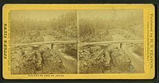
Dalles of the St. Louis, by R. N. Fearon
-
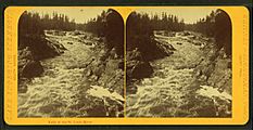
Falls of the St. Louis River, by Whitney & Zimmerman
-
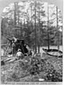
Loggers at Dalles of the Saint Louis River
-
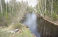
The Saint Louis River in its upper course in the Superior National Forest, near Hoyt Lakes, Minnesota


See also
 In Spanish: Río Saint Louis para niños
