
St. Louis County, Minnesota facts for kids
Quick facts for kids
St. Louis County
|
|
|---|---|

St. Louis County Courthouse in Duluth
|
|

Location within the U.S. state of Minnesota
|
|
 Minnesota's location within the U.S. |
|
| Country | |
| State | |
| Founded | February 20, 1855 |
| Named for | St. Louis River |
| Seat | Duluth |
| Largest city | Duluth |
| Area | |
| • Total | 6,860 sq mi (17,800 km2) |
| • Land | 6,247 sq mi (16,180 km2) |
| • Water | 612 sq mi (1,590 km2) 8.9%% |
| Population
(2020)
|
|
| • Total | 200,231 |
| • Estimate
(2023)
|
200,514 |
| • Density | 29.188/sq mi (11.270/km2) |
| Time zone | UTC−6 (Central) |
| • Summer (DST) | UTC−5 (CDT) |
| Congressional district | 8th |
St. Louis County is a large county located in the Arrowhead Region of the U.S. state of Minnesota. In 2020, about 200,231 people lived here. Its main city and government center is Duluth.
This county is the biggest in Minnesota by land area. It is also the largest in the entire United States by total area (including water) east of the Mississippi River. St. Louis County is part of the larger Duluth, MN–Superior, WI Metropolitan Statistical Area.
Important jobs in the county include making pulpwood (wood for paper) and tourism. Mining for taconite (a type of iron ore) and turning it into high-quality iron ore is also a big part of the economy. This mining is closely connected to shipping in the ports of Duluth and Superior. Parts of the Bois Forte and Fond du Lac Indian reservations are also located in the county.
Contents
History of St. Louis County
For a long time, this area was home to Native American tribes. These included the Ojibwe (Chippewa), Ottawa, and Potawatomi peoples. They were part of a group called the Council of Three Fires. As American settlers moved into the area, these Native American groups were moved to other places.
The Minnesota Legislature officially created St. Louis County on February 20, 1855. It was first called Doty County. Then, on March 3, 1855, its name changed to Newton County.
The county's borders changed a few times. On March 1, 1856, Newton County became St. Louis County. It also grew bigger by adding parts of Itasca County. On May 23, 1857, St. Louis County got its current shape. This happened when Carlton County was formed from parts of St. Louis and Pine counties.
Geography and Nature
St. Louis County is very large. It covers about 6,860 square miles. About 6,247 square miles are land, and 612 square miles (8.9%) are water. It is the biggest county in Minnesota. It is also the largest county by total area east of the Mississippi River in the United States. St. Louis County is unique because it has a coastline on Lake Superior. It also borders both Canada and another state, Wisconsin.
Voyageurs National Park was created in 1975. It is in the northwestern part of the county, near Rainy Lake and the Canada–US border. This park is popular for boating and fishing. The county also includes parts of Superior National Forest, which started in 1909. The Boundary Waters Canoe Area Wilderness (BWCAW) is also here. It is a huge wilderness area of about 1,090,000 acres. People enjoy fishing, camping, hiking, and canoeing there. It is one of the most visited wilderness areas in the United States. St. Louis County has more than 500 lakes! The biggest lakes are Pelican and Vermilion.
A special place called the "Hill of Three Waters" is northeast of Hibbing. Rain that falls on this hill flows in three different directions. It can go north to Hudson Bay, east to the Gulf of Saint Lawrence (through Lake Superior), or south and west to the Gulf of Mexico (through the Mississippi River). The county also has important rivers like the St. Louis and Vermilion.
Duluth, located on Lake Superior, is one of the most important freshwater ports in the United States. This means many ships come and go from here.
The county is also part of the Iron Range. This area is known for its taconite mining industry. Active mines are found in cities like Hibbing, Mountain Iron, Eveleth, Virginia, and Babbitt.
Main Roads in St. Louis County
 Interstate 35
 Interstate 535 – John Blatnik Bridge
 U.S. Highway 2
 U.S. Highway 53
 U.S. Highway 169
 Minnesota State Highway 1
 Minnesota State Highway 23
 Minnesota State Highway 33
 Minnesota State Highway 37
 Minnesota State Highway 39 – McCuen Street
 Minnesota State Highway 61 – North Shore
 Minnesota State Highway 73
 Minnesota State Highway 135
 Minnesota State Highway 169
 Minnesota State Highway 194
 Minnesota State Highway 210
 St. Louis County Road 4 - Rice Lake Road
 – Midway Road

Neighboring Counties and Districts
- Rainy River District, Ontario, Canada (north)
- Lake County (east)
- Douglas County, Wisconsin (southeast)
- Carlton County (south)
- Aitkin County (southwest)
- Itasca County (west)
- Koochiching County (northwest)
Protected Natural Areas
- Superior National Forest (part)
- Boundary Waters Canoe Area Wilderness (part)
- Voyageurs National Park (part)
Climate and Weather
St. Louis County has a humid continental climate. This means it has warm summers and cold, snowy winters. Winters are very long and cold. Temperatures often stay below freezing for many days.
In January 2019, the county experienced extremely cold wind chills, feeling like -70°F (-57°C). This was so cold that schools and government offices had to close. Scientists linked this unusual cold to changes in global weather patterns.
Population and People
| Historical population | |||
|---|---|---|---|
| Census | Pop. | %± | |
| 1860 | 406 | — | |
| 1870 | 4,561 | 1,023.4% | |
| 1880 | 4,504 | −1.2% | |
| 1890 | 44,862 | 896.0% | |
| 1900 | 82,932 | 84.9% | |
| 1910 | 163,274 | 96.9% | |
| 1920 | 206,391 | 26.4% | |
| 1930 | 204,596 | −0.9% | |
| 1940 | 206,917 | 1.1% | |
| 1950 | 206,062 | −0.4% | |
| 1960 | 231,588 | 12.4% | |
| 1970 | 220,693 | −4.7% | |
| 1980 | 222,229 | 0.7% | |
| 1990 | 198,213 | −10.8% | |
| 2000 | 200,528 | 1.2% | |
| 2010 | 200,226 | −0.2% | |
| 2020 | 200,231 | 0.0% | |
| 2023 (est.) | 200,514 | 0.1% | |
| U.S. Decennial Census 1790–1960 1900–1990 1990–2000 2010–2020 |
|||
Population Data from 2020
The 2020 census showed that St. Louis County had 200,231 people.
Asianalone (NH)
| Race / Ethnicity | Pop 2010 | Pop 2020 | % 2010 | % 2020 |
|---|---|---|---|---|
| White alone (NH) | 184,769 | 176,112 | 92.3% | 88.0% |
| Black or African American alone (NH) | 2,588 | 4,075 | 1.3% | 2.0% |
| Native American or Alaska Native alone (NH) | 4,277 | 4,305 | 2.1% | 2.1% |
| 1,760 | 1,901 | 0.9% | 1.0% | |
| Pacific Islander alone (NH) | 60 | 58 | nil% | nil% |
| Some Other Race alone (NH) | 95 | 579 | 0.1% | 0.3% |
| Mixed Race/Multi-Racial (NH) | 4,168 | 9,598 | 2.1% | 4.8% |
| Hispanic or Latino (any race) | 2,409 | 3,603 | 1.2% | 1.8% |
| Total | 200,226 | 200,231 | 100% | 100% |
Note: The US Census counts Hispanic/Latino as an ethnic group. This table separates them from racial groups. People who are Hispanic/Latino can be of any race.
Population Data from 2010
In 2010, the county had 200,226 people. Most people were White (94.0%). There were also Native American (2.2%), Black or African American (0.4%), and Asian (0.9%) residents. About 2.3% of people were of two or more races. About 1.2% of the population was Hispanic or Latino.
Many people in the county have roots from Europe. The largest groups include German (24.3%), Norwegian (15.9%), Swedish (13.0%), and Irish (10.2%).
Cities and Towns
Cities in St. Louis County
Townships in St. Louis County
- Alango Township
- Alborn Township
- Alden Township
- Angora Township
- Arrowhead Township
- Ault Township
- Balkan Township
- Bassett Township
- Beatty Township
- Biwabik Township
- Breitung Township
- Brevator Township
- Camp 5 Township
- Canosia Township
- Cedar Valley Township
- Cherry Township
- Clinton Township
- Colvin Township
- Cotton Township
- Crane Lake Township
- Culver Township
- Duluth Township
- Eagles Nest Township
- Ellsburg Township
- Elmer Township
- Embarrass Township
- Fairbanks Township
- Fayal Township
- Field Township
- Fine Lakes Township
- Floodwood Township
- Fredenberg Township
- French Township
- Gnesen Township
- Grand Lake Township
- Great Scott Township
- Greenwood Township
- Halden Township
- Industrial Township
- Kabetogama Township
- Kelsey Township
- Kugler Township
- Lakewood Township
- Lavell Township
- Leiding Township
- Linden Grove Township
- McDavitt Township
- Meadowlands Township
- Midway Township
- Morcom Township
- Morse Township
- Ness Township
- New Independence Township
- Normanna Township
- North Star Township
- Northland Township
- Owens Township
- Pequaywan Township
- Pike Township
- Portage Township
- Prairie Lake Township
- Sandy Township
- Solway Township
- Stoney Brook Township
- Sturgeon Township
- Toivola Township
- Van Buren Township
- Vermilion Lake Township
- Waasa Township
- White Township
- Willow Valley Township
- Wuori Township
Unorganized Areas
- Angleworm Lake
- Bear Head Lake
- Birch Lake
- Camp A Lake
- Crab Lake
- Dark River
- Gheen
- Hay Lake
- Heikkala Lake
- Hush Lake
- Janette Lake
- Leander Lake
- Linwood Lake
- Marion Lake
- McCormack
- Mud Hen Lake
- Nett Lake
- Northeast St. Louis
- Northwest St. Louis
- Pfeiffer Lake
- Picket Lake
- Potshot Lake
- Sand Lake
- Slim Lake
- Sturgeon River
- Sunday Lake
- Tikander Lake
- Whiteface Reservoir
Special Census Areas
Small Unincorporated Communities
- Alborn
- Angora
- Ash Lake
- Bassett
- Bear River
- Bengal
- Brimson
- Britt
- Burnett
- Burntside
- Buyck
- Canyon
- Celina
- Central Lakes
- Cherry
- Clover Valley
- Cotton
- Crane Lake
- Culver
- Cusson
- Eldes Corner
- Elmer
- Embarrass
- Fairbanks
- Florenton
- Forbes
- Four Corners
- French River
- Gheen
- Gheen Corner
- Glendale
- Gowan
- Greaney
- Idington
- Independence
- Island Lake
- Kabetogama
- Keenan
- Kelsey
- Linden Grove
- Makinen
- Markham
- McComber
- Meadow Brook
- Melrude
- Munger
- Palmers
- Palo
- Payne
- Peary
- Petrel
- Peyla
- Pineville
- Prosit
- Ramshaw
- Robinson
- Rollins
- Saginaw
- Sax
- Shaw
- Sherman Corner
- Side Lake
- Silica
- Simar
- Skibo
- Sturgeon
- Taft
- Toivola
- Twig
- Vermilion Dam
- Wakemup
- Whiteface
- Wolf
- Zim
Old Ghost Towns
- Carson Lake
- Costin Village
- Elcor
- Fermoy
- Spina
Images for kids
-
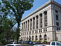
St. Louis County Courthouse in Duluth
See also
 In Spanish: Condado de St. Louis (Minnesota) para niños
