Orr, Minnesota facts for kids
Quick facts for kids
Orr, Minnesota
|
|
|---|---|

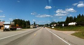
U.S. Highway 53 serves as a main route in Orr
|
|

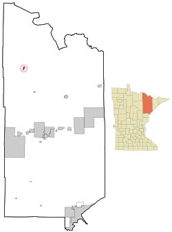
Location of the city of Orr
within Saint Louis County, Minnesota |
|
| Country | United States |
| State | Minnesota |
| County | Saint Louis |
| Incorporated | June 7, 1935 |
| Area | |
| • Total | 1.423 sq mi (3.686 km2) |
| • Land | 1.402 sq mi (3.630 km2) |
| • Water | 0.021 sq mi (0.054 km2) |
| Elevation | 1,303 ft (397 m) |
| Population
(2020)
|
|
| • Total | 211 |
| • Estimate
(2022)
|
214 |
| • Density | 150.50/sq mi (58.13/km2) |
| Time zone | UTC−6 (Central (CST)) |
| • Summer (DST) | UTC−5 (CDT) |
| ZIP Code |
55771
|
| Area code(s) | 218 |
| FIPS code | 27-48634 |
| GNIS feature ID | 0662112 |
| Sales tax | 7.375% |
Orr is a small city in Minnesota, located in Saint Louis County. In 2020, about 211 people lived there.
U.S. Highway 53 is an important road that goes through Orr.
Orr is found inside the beautiful Kabetogama State Forest. It's a popular spot for people who love riding ATVs and snowmobiles, especially in winter.
Contents
History of Orr
Orr began as a town focused on lumber, which means cutting down trees for wood. The first post office opened in 1907. The community was named after William Orr, who was an early postmaster.
Geography and Climate
Orr is located in Saint Louis County, Minnesota. The city covers about 1.42 square miles (3.68 square kilometers). Most of this area is land, with a small part being water.
Orr is also located along Pelican Lake.
Orr's Weather Patterns
Orr has a type of weather called a dry winter humid continental climate. This means it has cold, snowy winters and warm summers.
Here's a quick look at the weather in Orr:
- Coldest Month: January, with an average temperature of about 3.5°F (minus 15.8°C).
- Warmest Month: July, with an average temperature of about 63°F (17.2°C).
- Rainiest Months: June and July, with over 4 inches (10 cm) of rain each.
- Snowiest Months: December and January, with over 14 inches (35 cm) of snow each.
Population and People
| Historical population | |||
|---|---|---|---|
| Census | Pop. | %± | |
| 1940 | 234 | — | |
| 1950 | 309 | 32.1% | |
| 1960 | 361 | 16.8% | |
| 1970 | 315 | −12.7% | |
| 1980 | 294 | −6.7% | |
| 1990 | 265 | −9.9% | |
| 2000 | 249 | −6.0% | |
| 2010 | 267 | 7.2% | |
| 2020 | 211 | −21.0% | |
| 2022 (est.) | 214 | −19.9% | |
| U.S. Decennial Census 2020 Census |
|||
How Many People Live in Orr?
According to the 2010 census, 267 people lived in Orr. There were 117 households, which are groups of people living together in one home. About 69 of these were families.
Most people living in Orr were White (80.9%). About 18.4% were Native American.
Families and Age in Orr
- About 28% of households had children under 18 years old.
- 41% of households were married couples living together.
- The average household had 2.28 people.
- The average family had 2.96 people.
The average age of people in Orr was 42.1 years old.
- About 23.6% of residents were under 18.
- About 14.6% were 65 years or older.
- The city had slightly more males (51.3%) than females (48.7%).
Getting Around Orr
Orr Regional Airport
Orr has its own airport called Orr Regional Airport. This makes it easier for people to travel to and from the area.
Images for kids
See also
 In Spanish: Orr (Minnesota) para niños
 | Percy Lavon Julian |
 | Katherine Johnson |
 | George Washington Carver |
 | Annie Easley |


