McKinley, St. Louis County, Minnesota facts for kids
Quick facts for kids
McKinley, Minnesota
|
|
|---|---|

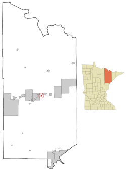
Location of the city of McKinley
within Saint Louis County, Minnesota |
|
| Country | United States |
| State | Minnesota |
| County | St. Louis |
| Founded | 1890 |
| Incorporated | 1892 |
| Area | |
| • Total | 1.571 sq mi (4.070 km2) |
| • Land | 1.426 sq mi (3.692 km2) |
| • Water | 0.147 sq mi (3.812 km2) |
| Elevation | 1,480 ft (451 m) |
| Population
(2020)
|
|
| • Total | 103 |
| • Estimate
(2022)
|
104 |
| • Density | 72.23/sq mi (27.90/km2) |
| Time zone | UTC−6 (Central (CST)) |
| • Summer (DST) | UTC−5 (CDT) |
| ZIP Code |
55741
|
| Area code(s) | 218 |
| FIPS code | 27-39140 |
| GNIS feature ID | 0661888 |
| Sales tax | 7.375% |
McKinley is a small city in Saint Louis County, Minnesota, United States. It is part of the Iron Range region. This area is famous for its rich iron ore deposits. In 2020, about 103 people lived in McKinley.
The main roads in McKinley include State Highway 135 (MN 135), Saint Louis County Road 20 (CR 20), and Main Street. The city is located about seven miles east of Virginia. Other nearby towns are Gilbert and Biwabik.
Contents
History of McKinley
McKinley got its name from three brothers: Duncan, John, and William McKinley. They were important businessmen in the mining industry. A post office opened in McKinley in 1892. The city itself was officially formed in 1892. The post office served the community until 1991.
Geography of McKinley
McKinley covers a total area of about 1.571 square miles (4.07 km2). Most of this area, 1.426 square miles (3.69 km2), is land. The rest, 0.147 square miles (0.38 km2), is water. This means there are small lakes or rivers within the city limits.
Population and People
| Historical population | |||
|---|---|---|---|
| Census | Pop. | %± | |
| 1900 | 262 | — | |
| 1910 | 411 | 56.9% | |
| 1920 | 395 | −3.9% | |
| 1930 | 304 | −23.0% | |
| 1940 | 235 | −22.7% | |
| 1950 | 196 | −16.6% | |
| 1960 | 408 | 108.2% | |
| 1970 | 317 | −22.3% | |
| 1980 | 230 | −27.4% | |
| 1990 | 116 | −49.6% | |
| 2000 | 80 | −31.0% | |
| 2010 | 128 | 60.0% | |
| 2020 | 103 | −19.5% | |
| 2022 (est.) | 104 | −18.7% | |
| U.S. Decennial Census 2020 Census |
|||
McKinley's Population in 2010
In 2010, McKinley had 128 residents living in 56 households. About 36 of these households were families. The city had about 87.7 inhabitants per square mile (33.9/km2) people per square mile. There were 67 homes, with about 45.9 per square mile (17.7/km2) homes per square mile.
Most of the people in McKinley (93.8%) were White. About 4.7% were from other racial backgrounds, and 1.6% identified with two or more races. About 6.3% of the population was Hispanic or Latino.
About 28.6% of households had children under 18 living with them. Nearly half (48.2%) were married couples. Some households (12.5%) had a female head of household without a husband. A small number (3.6%) had a male head of household without a wife. About 35.7% of households were not families.
Almost one-third (32.1%) of all households were single individuals. About 21.4% of households had someone aged 65 or older living alone. The average household had 2.29 people, and the average family had 2.92 people.
The average age in McKinley in 2010 was 42.5 years. About 25.8% of residents were under 18. About 19.5% were 65 or older. The population was 43.8% male and 56.3% female.
See also
 In Spanish: McKinley (Minnesota) para niños
 | Ernest Everett Just |
 | Mary Jackson |
 | Emmett Chappelle |
 | Marie Maynard Daly |

