Wrenshall, Minnesota facts for kids
Quick facts for kids
Wrenshall
|
|
|---|---|
 |
|

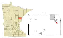
Location of the city of Wrenshall
within Carlton County, Minnesota |
|
| Country | United States |
| State | Minnesota |
| County | Carlton |
| Area | |
| • Total | 1.49 sq mi (3.86 km2) |
| • Land | 1.49 sq mi (3.86 km2) |
| • Water | 0.00 sq mi (0.00 km2) |
| Elevation | 1,040 ft (317 m) |
| Population
(2020)
|
|
| • Total | 428 |
| • Density | 287.06/sq mi (110.85/km2) |
| Time zone | UTC-6 (Central (CST)) |
| • Summer (DST) | UTC-5 (CDT) |
| ZIP codes |
55749, 55797
|
| Area code(s) | 218 |
| FIPS code | 27-71788 |
| GNIS feature ID | 0654392 |
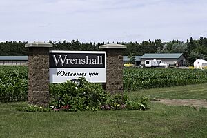
Wrenshall is a small city located in Carlton County, Minnesota, in the United States. It started out as a place where bricks were made. In 2020, about 428 people lived there. Wrenshall is also very close to a beautiful natural area called Jay Cooke State Park.
Contents
Where is Wrenshall Located?
Wrenshall is a city that covers about 1.5 square miles (3.86 square kilometers) of land. It has no water area. The city is about nine miles southeast of Cloquet. It is also 25 miles southwest of Duluth.
How to Get to Wrenshall
Several roads help people get to and from Wrenshall. Carlton County Roads 1, 4, and 18 are important local routes. State Highways 45 and 210 are four miles north in Carlton. State Highway 23 is 2.5 miles east in Silver Brook Township.
You can also reach Wrenshall from Interstate 35. One way is to take State Highways 45 or 210 to County Road 1 at Carlton. Another option is to use the County Road 4 exit at nearby Mahtowa.
Who Lives in Wrenshall?
| Historical population | |||
|---|---|---|---|
| Census | Pop. | %± | |
| 1930 | 186 | — | |
| 1940 | 168 | −9.7% | |
| 1950 | 148 | −11.9% | |
| 1960 | 189 | 27.7% | |
| 1970 | 147 | −22.2% | |
| 1980 | 333 | 126.5% | |
| 1990 | 296 | −11.1% | |
| 2000 | 308 | 4.1% | |
| 2010 | 399 | 29.5% | |
| 2020 | 428 | 7.3% | |
| U.S. Decennial Census | |||
The population of Wrenshall has changed over the years. In 2010, there were 399 people living in the city. The population density was about 266 people per square mile. Most residents were White, with some Native American and people of two or more races.
Families and Age Groups
In 2010, there were 154 households in Wrenshall. About 31% of these households had children under 18 living there. Most households (59%) were married couples. Some households were led by a single parent.
The average age of people in Wrenshall was 43.5 years old. About 25% of residents were under 18. Around 14.5% were 65 years or older. The city had slightly more females than males.
Learning in Wrenshall
The Wrenshall School District serves the students in Wrenshall. The school's mascot is the wren, a small bird. For sports, Wrenshall teams often join with teams from Carlton. Together, they are known as the Carlton Wrenshall Raptors.
See also
 In Spanish: Wrenshall (Minnesota) para niños
 | Ernest Everett Just |
 | Mary Jackson |
 | Emmett Chappelle |
 | Marie Maynard Daly |

