North Shore (Lake Superior) facts for kids

The North Shore is a beautiful area along Lake Superior. It stretches from Duluth, Minnesota, in the United States, all the way to Thunder Bay and Nipigon, Ontario, Canada, and then east to Sault Ste. Marie, Ontario. This amazing coastline has rocky cliffs and smooth stone beaches. You'll also find thick forests, hills, and many rivers with waterfalls flowing into Lake Superior.
Contents
History of the North Shore
Ancient Times
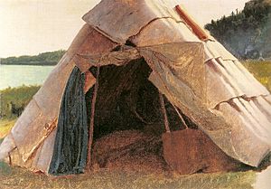
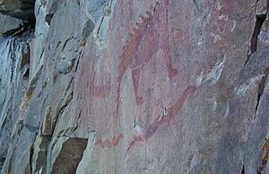
People first settled near Lake Superior around 8,000 BC. This was when the huge Wisconsin Glaciers started to melt away. By 500 BC, a group called the Laurel people lived here. They traded metal with other native groups. The Laurel people believed spirits were in nature. They likely made the rock paintings you can still see on cliffs along the North Shore.
Later, around the 12th century, the ancestors of the Ojibwa people moved into the eastern part of the North Shore. They left behind small pits in the ground, which archaeologists call Pukaskwa Pits. By the 18th century, the Ojibwa had settled along most of the North Shore. The Minnesota part of the North Shore was also home to the Cree people. The Dakota lived to the south.
The Fur Trade Era
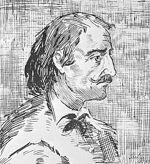
The first European explorer to reach Lake Superior was Étienne Brûlé from France. He was sent by Samuel de Champlain in 1623 or 1624. His trip helped Champlain create the first map of the lake in 1632.
Later, in 1658, two French explorers, Pierre-Esprit Radisson and Médard des Groseilliers, sailed all the way around Lake Superior. When they returned, they brought many Native Americans with animal furs. This sparked a lot of interest in the fur trade in the Lake Superior area.
In 1670, the Hudson's Bay Company was started, which boosted the fur trade. Daniel Greysolon, Sieur du Lhut, helped make peace between native tribes. This made trade safer across Lake Superior for the French. This peace helped set up European settlements on the North Shore. Fort Kaministiquia, near modern Thunder Bay, was built in 1683.
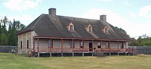
In 1763, the British took control of all French lands east of the Mississippi River. This included the North Shore. In 1784, the North West Company started a new fort at Grand Portage. They built many new forts and trading posts along the North Shore. However, in 1821, the North West Company had to join with the Hudson's Bay Company. As fewer fur animals were left, the fur trade slowed down.
Early Settlements
As American settlers moved west, the United States and Britain argued about the border. Surveys of the land showed many valuable minerals. In 1854, the LaPointe Treaty gave Ojibwa lands to the U.S. government.
White settlers then moved in to mine these natural resources. This started American settlements in Minnesota. Towns like Duluth, Knife River, and Beaver Bay were founded. By 1857, 99 fishermen lived in northern Minnesota. But an economic problem made most people leave. In 1865, the Vermilion Lake Gold Rush brought new settlers.
Real American settlement began in 1869. The Lake Superior & Mississippi Railroad made travel much faster. Duluth grew from 14 families to 3,500 people in just six months! Work began on the Duluth Harbor for shipping. The town of Beaver Bay started as a fishing village. Grand Marais was founded in 1871. Another economic problem in 1873 caused Duluth's population to shrink.
In the 1880s, growth started again in Minnesota and Canada. The Canadian Pacific Railway opened in 1881, bringing many new settlers. In Minnesota, Two Harbors became a big port for iron ore. Fishing also became a major industry. In 1885, 195 commercial fishermen lived in Duluth. Fish catches peaked at 10,000 tons in 1915 but have since dropped.
Iron Mining
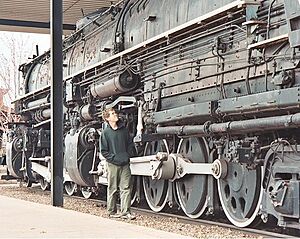
In 1875, a businessman named Charlemagne Tower looked into mining iron inland from the North Shore. He bought land in the Vermilion Range, where the iron ore was very rich. Tower also got rights to build the Duluth Iron & Railway Co.. This railway would connect Duluth to Agate Bay (now Two Harbors).
The railway was finished in 1887. Two large wooden docks were built in the harbor to ship iron. By 1887, the Minnesota Iron Company owned many miles of track, land, trains, and mines.
This success caught the eye of Henry H. Porter, a Chicago railroad owner. He bought more land up the North Shore. Porter convinced Tower to sell the Minnesota Iron Company for $8.5 million. He opened several new mines. By 1896, over 2,000,000 tons of iron were shipped through Two Harbors. Over the years, Two Harbors built more docks, replacing wooden ones with concrete.
Iron mining continued for many decades. By the 1950s, most traditional iron mines were running out. But northern Minnesota had an ore called taconite. This could be turned into iron using a special process. A taconite plant was built at Silver Bay. It quickly became a major shipping port for taconite. Today, taconite produces more than half of the iron mined in Minnesota.
Forests and Lumber
Northern Minnesota is mostly covered by a huge forest. People knew early on that the lumber here was valuable. But it was too far to ship. As forests in the east were cut down, the lumber industry moved to Wisconsin and Minnesota.
Lumber and wood products were shipped by train from Duluth and Superior, Wisconsin. Today, many forests along the North Shore are protected. But there is still a strong paper industry that uses pulpwood from the trees.
Fun and Tourism
In 1855, a lock system allowed steamboats onto Lake Superior. This meant tourists from the east could visit for fun. They would canoe or take ferries from Duluth up the North Shore. They often stayed in hunting and fishing camps.
In the 1920s, the North Shore highway was built. This made it easier to reach the area by car. At the same time, many commercial fishermen lost their jobs as fish catches went down. Many of these fishermen built cabins and resorts. Richer people then rented these for their vacations. Some special clubs also bought land for private getaways. The Naniboujou Club Lodge was built to attract wealthy guests.
In the early 1900s, the government decided to protect the North Shore. In 1909, President Teddy Roosevelt created the Superior National Forest. This protected over 3 million acres of forests. The Minnesota government also started buying land for state parks. Jay Cooke State Park was the first, created in 1915. In the 1930s, the Civilian Conservation Corps built rustic structures in what would become several North Shore state parks.
Today, the North Shore Scenic Drive is a very popular route for tourists. It starts at the historic Glensheen Mansion and passes many state parks, ending at Grand Portage.
Geology of the North Shore
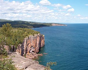
The North Shore sits on the north side of the Midcontinent Rift System. This was a huge crack in the Earth's crust that ran for 1,300 miles. It went from southern Michigan, through what is now Lake Superior, and into Kansas. As the Earth's crust pulled apart, hot lava flowed up from deep inside the Earth. This lava cooled and formed a hard rock called basalt.
The forces pulling the land apart were not strong enough to keep going. When the pulling stopped, the lava cooled. The heavy rock then sank and was filled with sediment (like sand and mud).
During recent glaciations (Ice Ages), huge glaciers moved across the land. They scraped away much of the basalt and sandstone, which are softer than granite. This scraping created the rough, rugged shoreline we see today. As the glaciers melted, they left behind eroded igneous rock (volcanic rock). Much of this rock now covers the rocky beaches on the North Shore.
The melting ice filled the basin, forming the Great Lakes. The shoreline was once much higher and much lower than it is today. About 2,000 years ago, the water levels of Lake Michigan and Lake Huron dropped. This created rapids at Sault Sainte Marie, which controlled the water flowing out of Lake Superior. This brought the shoreline to its current level.
The modern shoreline is made of basalt lava flows. Near Duluth, you can find other rocks like slate and sandstone a bit inland. But further north, the main rock is basalt and gabbro. Where the rock meets the lake at a gentle angle, the beaches are covered with smooth, washed-up stones. Where the rock meets the lake steeply, it forms sharp cliffs that drop right into the water.
Attractions
Minnesota Attractions
- Duluth
- Highway 61 and the North Shore Scenic Drive
- Glensheen Mansion
- Two Harbors
- Superior National Forest
- Superior Hiking Trail
- Silver Bay
- Schroeder
- Tofte (home of the North Shore Commercial Fishing Museum)
- North Country Trail
- Grand Marais
- Gunflint Trail
- Lutsen Mountains ski resorts
State Parks and National Monument
Many people enjoy camping in the state parks along Minnesota's North Shore. The "North Shore state parks" include parks right on the lake and others along rivers that flow into the lake.
- Jay Cooke State Park is on the Saint Louis River. This river flows into Lake Superior near Duluth.
- Gooseberry Falls State Park has campgrounds close to Lake Superior. Its main attractions are five waterfalls on the Gooseberry River and the Gitchi Gummi Trail.
- Split Rock Lighthouse State Park is famous for its historic Split Rock Lighthouse. You can visit the lighthouse, but there's a separate fee.
- Tettegouche State Park is at the mouth of the Baptism River. It's known for its high cliffs overlooking Lake Superior. Palisade Head, Minnesota's highest cliff, is just outside the park.
- George H. Crosby Manitou State Park is the only state park on Lake Superior that only offers backpacking campsites. These are on the Manitou River, away from the lake.
- Temperance River State Park has camping very close to Lake Superior. The main attractions are the waterfalls on the Temperance River.
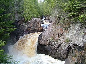
- Cascade River State Park is well known for the seven beautiful waterfalls on the Cascade River.
- Judge C. R. Magney State Park is the northernmost camping spot on Minnesota's North Shore. It has the Devil's Kettle waterfall on the Brule River. One part of the river disappears into a hole in the rock!
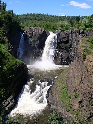
- Grand Portage State Park is near, but separate from, Grand Portage National Monument. It includes the High Falls on the Pigeon River, which marks the border with Ontario. This park does not have camping.
- Grand Portage National Monument has a rebuilt historic fur trading post. You can also learn about traditional Ojibwa culture here. There is no vehicle-accessible camping.
Ontario Attractions
Provincial and National Parks
Many Ontario Provincial Parks are undeveloped nature reserves. They don't have campgrounds or visitor centers.
- Lake Superior National Marine Conservation Area is a huge protected area created in 2007.
- Pigeon River Provincial Park is on the Canadian side of the Pigeon River.
- Sleeping Giant Provincial Park is a large natural environment park on the Sibley Peninsula. It offers camping.
- Shesheeb Bay Provincial Park is a small nature reserve on the Black Bay Peninsula.
- Gravel River Provincial Park is an undeveloped nature reserve on the Gravel River.
- Rainbow Falls Provincial Park offers camping.
- Prairie River Mouth Provincial Park is a nature reserve with only one footpath.
- Neys Provincial Park is on a remote peninsula. It offers camping.
- Red Sucker Point Provincial Park is a small nature reserve on Lake Superior's shore.
- Lake Superior Provincial Park is the largest provincial park on the lakeshore. It has modern camping and many hiking trails.
- Montreal River Provincial Park is a nature reserve you can only reach by boat.
- Pancake Bay Provincial Park is a recreation park with camping. The famous Edmund Fitzgerald shipwreck is near here.
- Batchawana Bay Provincial Park is a recreation park with a rare sandy beach.
- Pukaskwa National Park is the largest national park in Ontario. It has some camping facilities.
 | Bayard Rustin |
 | Jeannette Carter |
 | Jeremiah A. Brown |


