Rove Formation facts for kids
The Rove Formation is a special layer of sedimentary rock found in northeastern Cook County, Minnesota, USA, and stretching into Ontario, Canada. It's the youngest part of a larger group of rocks called the Animikie Group.
Long, long ago, even before the Rove Formation was created, huge landmasses collided. This event, called the Algoman orogeny, added land from South Dakota all the way to the Lake Huron area. Millions of years later, a thin layer of tiny bits of rock and dust fell onto the older Gunflint Iron Formation. This dust came from a massive meteor impact in Sudbury, Canada. Imagine an earthquake so strong it would have been a 10.2 on the Richter scale! The Rove Formation then formed on top of this meteor dust.
During the Middle Precambrian time, a shallow inland sea covered much of the Lake Superior region. This sea helped create the Animikie Group of sedimentary rocks, which sit on top of even older rocks (about 2.7 billion years old).
After the Rove Formation sediments settled, another big event, the Penokean orogeny, added more land from the south. A few hundred million years later, the early North American continent almost split in half! This happened along a giant crack in the Earth called the Midcontinent Rift, which stretches from Kansas, through the Lake Superior area, and into Michigan. After that, huge glaciers moved across the land, shaping it. The tough, hard rocks like diabase sills and dikes stayed, but the softer shales were pushed away by the glaciers.
Because of the way the hard and soft rocks eroded, the land in Minnesota has many parallel hills and valleys. The lakes in these narrow valleys are long and thin, running from east to west. The cliffs in these valleys are home to some rare plants that like the cool, almost sub-Arctic climate. In Ontario, the Rove Formation is covered by a thick layer of diabase rock.
Contents
Where is the Rove Formation?
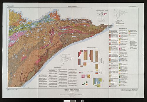
The Rove Formation is located in the Arrowhead Region of northeastern Minnesota, USA, and continues into Ontario, Canada. In Minnesota, you can find it along the US-Ontario border, from Gunflint Lake to Pigeon Point. Pigeon Point is the easternmost part of Minnesota, and it's a thick diabase sill, like a huge, flat rock layer. Both the north and south sides of Pigeon Point show Rove slates (a type of shale) above and below this hard rock layer.
In Minnesota, the Rove Formation creates many east-west hills and valleys. Many lakes in this 5 to 8 km (3 to 5 mi) wide strip along the Canada–US border are found in these long, narrow valleys. Some of these lakes include Caribou, Clearwater, Crocodile, Daniels, Duncan, Dunn, Hungry Jack, Iron, Loon, Moose, Pine, Portage, and South. In Ontario, a thick diabase sill covers the Rove Formation.
How the Rove Formation Formed: A Geologic Story
The Ancient Archean Eon
The Archean Eon was a very long time ago, from about 3.8 billion to 2.5 billion years ago.
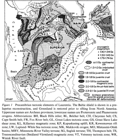
The Algoman orogeny happened between 2.8 billion and 2.5 billion years ago. This was a time when huge pieces of the Earth's crust collided, pushing up mountains. This event added land along a line from South Dakota to the Lake Huron area, creating what is now called the Great Lakes tectonic zone.
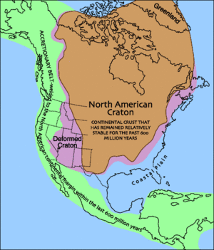
In northeast Minnesota, rocks that are 2.7 billion years old can be seen. These rocks formed from lava flowing out of cracks on the ancient seafloor. These lava flows eventually rose out of the ocean to form the Superior craton, which later became part of the Canadian shield and then the North American craton. The Superior craton is the largest piece of ancient crust still preserved today.
The Proterozoic Eon
The Proterozoic Eon lasted from about 2.5 billion to 570 million years ago.
The Animikie Group
The Animikie Basin is a large, oval-shaped area, about 700 km (420 mi) long and 400 km (240 mi) wide, located near the North Shore of Lake Superior. Most of it is in Minnesota, with a part extending under Lake Superior.
During the Middle Precambrian, a shallow inland sea covered much of the Lake Superior region. This sea created the Animikie Group, which are layers of sedimentary rocks resting on top of 2.7-billion-year-old Archean rocks. The Animikie Group includes both the Rove Formation and the Gunflint Iron formation. The Rove Formation is the youngest of these layers. It's made of gently tilted, fine-grained sediments like greywackes (a type of sandstone) and black shale. It has less iron and taconite than the older Gunflint Iron Formation beneath it.
The Rove Formation has three main parts: a lower layer of argillite (a fine-grained rock like hardened mud), a middle layer that mixes rock types, and an upper layer mostly of thin-bedded greywacke. The lower argillite layer is about 150 meters (490 ft) thick. The upper two layers together are about 900 meters (2,950 ft) thick.
The Penokean Mountain Building
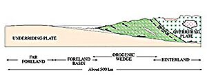
The Penokean Mountain Range formed between 1.88 billion and 1.83 billion years ago. This happened when an island arc (a chain of volcanic islands) called the Pembine–Wausau terrane crashed into the southern edge of the Superior craton. This collision pushed rocks up, creating a mountain range that covered parts of Minnesota, Wisconsin, Michigan, and southern Ontario. The weight of these new mountains caused the Earth's crust to bend downwards, forming a basin. The Rove Formation sediments were deposited in the northern part of this basin.
The Sudbury Meteor Impact
At the very bottom of the Rove Formation, just above the Gunflint Iron Formation, there's a thin layer of special rock fragments. These fragments, including shocked quartz and tiny spheres, show that this layer came from a super-fast meteor impact. Scientists have dated this layer to about 1.85 billion years ago, which matches the timing of the Sudbury Impact event. This makes it the oldest meteor impact debris on Earth linked to a specific event!
This layer in the Rove area is about 7.6 meters (25 ft) thick. It likely represents the dramatic events of a single day nearly 1.85 billion years ago.
Evidence suggests a 16 km (10 mi) wide meteorite hit Earth near what is now Sudbury, Ontario, Canada, about 1.85 billion years ago. The impact created a huge crater, about 240 km (150 mi) wide, which is the second-largest impact crater on Earth. This impact site is about 770 km (480 mi) east of the Rove Formation area. The impact caused massive earthquakes and sent a cloud of ash, rock, and molten material flying around the world. It's estimated the earthquake at the impact site would have been a 10.2 on the Richter scale! Since the Rove Formation area was covered by seas at the time, the Sudbury impact also created giant tsunamis.
To give you an idea of how big this was, the Chicxulub impact (the one that wiped out the dinosaurs) happened 66 million years ago and was caused by an object only about 60% the size of the Sudbury meteor.
The Sudbury Impact likely had global effects. It's thought to have stopped the formation of iron deposits in the oceans. Before the impact, huge deposits of banded iron formations (rocks rich in iron oxides) were forming. This suddenly stopped around 1.85 billion years ago. In northeastern Minnesota, these iron-rich layers are found right under the meteor impact layer. Minnesota's famous Iron Range is made of this ancient iron-rich rock.
Most of the impact layer in the Rove area is made of a mix of rock fragments that were torn from the seafloor during the earthquakes. The tsunamis then mixed these fragments with the meteor debris. Over time, this layer was buried, hardened, and fused into solid rock. In 2007, geologists found Sudbury impact debris on the Gunflint Trail in Cook County, Minnesota. This was the farthest distance that Sudbury debris had ever been found!
The Midcontinent Rift
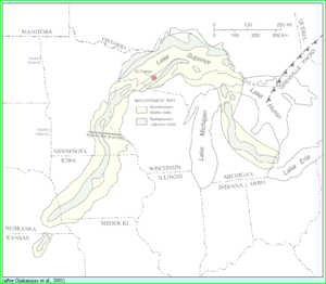
The Midcontinent Rift, also known as the Keweenawan Rift, began about 1.1 billion years ago and lasted for about 20 million years. After the Penokean Mountains had worn away, the early North American continent almost split in half along this giant crack. This 2,000 km (1,240 mi) long, bow-shaped rift stretched from Kansas, through Nebraska, Iowa, Minnesota, and the Lake Superior basin, then angled through Michigan.
The Midcontinent Rift is the largest known continental rift in the world. It started as a hot spot of molten rock (magma) under the Lake Superior region. This magma erupted, creating layers of lava up to 20 km (12 mi) thick, extending 100 km (60 mi) on either side of the rift. Along the North Shore of Lake Superior, the solidified lava is 7,620 meters (25,000 ft) thick!
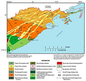
In the Rove region, the magma didn't reach the surface. Instead, it pushed into cracks in the existing rock and slowly cooled to form a hard rock called diabase. These solidified rock bodies are known as the Pigeon River and Logan Intrusion diabases.
The continent didn't completely split because another landmass, the Grenville province, was pushing against it from the east. This pressure stopped the rift from fully breaking apart the continent.
This rift was the last major volcanic or mountain-building event in what is now Minnesota. The solidified lava flows have since sagged, tilted, and faulted, creating a basin up to 5,000 meters (16,400 ft) deep along the rift zone. This basin eventually filled with water, forming the early Lake Superior.
The Puckwunge Formation
The Puckwunge Formation is made of buff to grey sandstone. These sediments were laid down during the early stages of the Midcontinent Rift, between 1.2 billion and 1.1 billion years ago.
You can see the Puckwunge sandstone in a very narrow band (only a few feet wide) along the southwestern edge of the Rove Formation. This band starts at Raspberry Point on Lake Superior in Minnesota and extends inland for about 40 km (25 mi) to the northwest. The Rove Formation is located to the northeast of this sandstone. The Rove Formation is also cut through by several bands of Pigeon River Diabase, which run from west to east.
The Ice Ages and Glaciation
The Quaternary Period began about 2 million years ago and continues today. This is the time of many glaciers advancing and retreating across the land. The Rove region has many tilted layers of volcanic rocks and soft, easily eroded shale. The tough diabase dikes and sills remained, but the softer shales were scraped away by the glaciers. These former shale valleys then filled with water, creating the many lakes in the area.
The Rainy Lobe of the Wisconsin glaciation was the most recent ice sheet, and it melted away about 10,000 years ago. Scratches on Rove rocks show that the glaciers moved from the north or slightly east of north. This direction is across the general trend of the valleys and ridges. The lakes in the Rove Formation area are unique because their long axes (the longest part of the lake) lie across the direction the glaciers moved.
When the huge continental glaciers moved over the Rove Formation, the ice was hundreds of meters thick. The ice was thicker over the valleys than over the ridges. This caused the ice to scrape away the easily eroded slates in the valleys. The ridges, made of tough diabase, were not eroded as much because the ice was thinner and less flexible over them.
The immense weight of the ice sheets pressed down on the land, creating depressions. As the glaciers melted and retreated, the pressure was relieved, and the land slowly rose back up. This process, called isostatic rebound, is still happening today and is estimated to be about 100 meters (330 ft) in total.
Today's Landscape
In Ontario, the shales and greywackes of the Rove Formation are covered by a 60-meter (200 ft) thick layer of diabase. This diabase layer is a remnant of a sill, and most of it is covered by a thick layer of soil. The flat-topped hills (like mesas) near Thunder Bay, such as Russell Point, are examples of this diabase sitting on top of the softer Rove Formation rocks. These flat-topped, steep-sided hills are known as the Nor'Wester Mountains.
In Minnesota, the Rove Formation area clearly shows how the bedrock affects the landscape, creating a unique valley-and-ridge pattern. There are many steep, east-west valleys formed by the erosion of the exposed shale. The diabase-capped ridges between the valleys slope gently to the south, but their northern faces are very steep, rising 60 to 140 meters (200 to 460 ft) above deep, cold lakes. This creates an asymmetrical (uneven) shape for the ridges. The valleys also have an asymmetrical shape, and they contain lakes carved out by glaciers. Most of these lakes have a steep underwater slope on their south shore. The steep, north-facing cliffs provide a home for a few species of rare plants. The Rove Formation has landscape features that are found nowhere else in Minnesota.
Most of the valleys are filled with chains of long lakes, many of which are surrounded by solid rock. Many of these east-west valleys end suddenly when the bordering hard rock layers merge. The lakes vary in elevation, from Rose Lake at 465 meters (1,526 ft) to Loon Lake at 532 meters (1,745 ft) above sea level. Lakes on opposite sides of a single ridge can have surface elevations that differ by as much as 60 meters (200 ft). Many of these rock-bound lakes are about 30 meters (100 ft) deep, and a few are deeper than 61 meters (200 ft).
A map shows that most of these tightly packed lakes and their valley-and-ridge landscape are in Minnesota, right along the Canada–US border. This border follows the Pigeon River and goes through the middle of lakes like South Fowl, North Fowl, Moose, Mountain, Watap, Rose, South, Little North, and Gunflint. Only a few Rove-typical east-west lakes, like Arrow and North lakes, are entirely in Ontario.
The ancient drainage pattern (how water flowed) was controlled by the rock structure. Major streams used to flow east in the shale belts. Short rivers and north-south sections of the main streams cut across ridges, forming small gaps that are still there today.
The Laurentian Continental Divide also runs through the Rove Formation. Between North Lake (Ontario) and South Lake (Minnesota), there's a low saddle of land right on the border. This is the divide: North Lake drains into the Rainy River and then to Hudson Bay, while South Lake drains into the Pigeon River and then to Lake Superior.
The topsoil in the Rove area is thin and poor because the glaciers scraped away most of it down to the bedrock. The soils that remain are mostly clayey silt.
Endangered Plants
This area, known as the Rove Slate Bedrock Complex Landtype Association, is special for its plants. The sedimentary and diabase rocks here contain calcareous minerals, which create a more basic, nutrient-rich soil compared to the poorer soils usually found in the Canadian shield. The Royal River, which drains Royal Lake into John Lake (both in Minnesota), contributes to this. The relatively rich soils, especially in the Royal River area, along with steep, moist, north-facing cliffs, provide the perfect habitat for rare plants. For over a century, this area has been known for its unique plants, including some of the rarest in Minnesota. Almost all the known sensitive plant species in this area grow on the north side of the cliffs or in the Royal River drainage.
Six vascular plants found here are unique because they are at the very edge of their normal range or are separated from their main populations. These include:
- Maidenhair spleenwort (Asplenium trichomanes L.): Only a few small groups of 20 to 40 plants have been found in the Rove area.
- Ross's (or Short) sedge (Carex rossii): Only three groups are known in the Rove area.
- Large-leaved sandwort (Moehringia macrophylla or Arenaria macrophylla): This is a very rare species with specific environmental needs.
- Sticky locoweed (Oxytropis borealis var. viscida): Found on only one cliff in Cook County.
- Encrusted saxifrage (Saxifraga paniculata ssp. neogaea): 11 groups are known in the Rove formation.
- Smooth Woodsia (Woodsia glabella): Small, isolated groups are found in the Rove Formation.
During plant surveys in 2003 and 2004, two other important plants were found:
- Canada Yew (Taxus canadensis): A sensitive plant in the Superior National Forest.
- Blunt-fruited sweet cicely (Osmorhiza depauperata): This species is of concern to the state, with only four groups found within 30 km (19 mi) of each other.
Minnesota's Department of Natural Resources lists these vascular plants as threatened:
- Rocky Mountain woodsia (Physematium scopulinum ssp. laurentiana): Few isolated groups exist in the formation.
- Holboell's rock-cress (Boechera retrofracta or Arabis holboellii var. retrofracta): Rare in both Ontario and Minnesota.
The Nodding saxifrage (Saxifraga cernua) is listed as endangered by Minnesota's Department of Natural Resources. One source calls it "very rare," noting that Cook County has Minnesota's only colony, with about a dozen plants covering less than 1 square meter (1.2 sq yd). This makes it very vulnerable to any changes in its habitat.
 | Bessie Coleman |
 | Spann Watson |
 | Jill E. Brown |
 | Sherman W. White |


