Drainage system (geomorphology) facts for kids
Drainage systems, also known as river systems, are the shapes and paths that streams, rivers, and lakes make in a specific area. This area is called a drainage basin. Think of a drainage basin as a big bowl where all the water flows towards a single river or lake.
These patterns depend on the land's shape (topography), how hard or soft the rocks are, and how steep the land is. Scientists who study landforms (geomorphologists) and water (hydrologists) look at how streams fit into these basins. The size and shape of these basins can be very different.
Contents
What are Drainage Patterns?
The way rivers and streams flow across the land creates different shapes, which we call drainage patterns. These patterns depend on the land's shape and the types of rocks underneath.
Accordant and Discordant Patterns
A drainage system is called accordant if its pattern matches the shape and structure of the land it flows over. This means the river follows the natural slopes and rock layers.
A discordant system, however, does not match the land's shape or geology. There are two main types of discordant patterns:
- Antecedent drainage: This happens when a river cuts down into the land at the same speed that the land is rising due to tectonic forces. The river was there first, and it keeps its path even as the mountains grow around it.
- Superimposed drainage: This occurs when a river first forms on top of younger, softer rocks. Over time, these softer rocks wear away, and the river continues to flow over older, harder rocks underneath. It looks like the river was "placed" on top of the new surface.
Dendritic Drainage Pattern
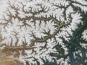
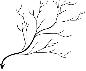
Dendritic drainage systems are the most common type. The word "dendritic" comes from a Greek word meaning "like a tree." These systems look like the branches of a tree. Many small streams (like twigs) join together to form larger streams (like branches), which then flow into a main river (like the tree trunk).
These patterns usually form in areas where the land slopes evenly. The rocks in these areas are often hard and don't let water soak through easily.
Parallel Drainage Pattern
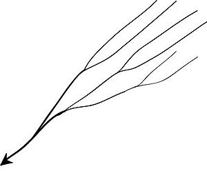
A parallel drainage system happens when rivers and streams flow side-by-side in the same direction. They are often found on long, uniform slopes or where there are long, resistant rock bands. The water flows quickly and straight, with very few smaller streams joining them.
You can see this pattern in rivers flowing from the Aberdare Mountains in Kenya or many rivers in Myanmar. Sometimes, this pattern can show where a major crack (fault) cuts across an area of steeply folded rock.
Trellis Drainage Pattern
A trellis drainage system looks like a garden trellis. In this pattern, smaller streams flow down steep mountain slopes and join a main river at almost right angles. This creates a grid-like appearance.
Trellis patterns form where there are alternating layers of hard and soft rocks on both sides of the main river. This pattern is common in folded mountains, like the Appalachian Mountains in North America.
Rectangular Drainage Pattern
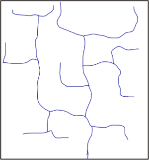
Rectangular drainage patterns develop in areas where rocks are equally resistant to erosion, but they have cracks (joints) that cross each other at about 90-degree angles. Water tends to flow along these cracks because they are weaker than the main rock.
This results in a system where streams mostly follow straight lines, with sharp, right-angle bends. Smaller streams also join larger ones at right angles. The Arun River in Nepal shows this pattern.
Radial Drainage Pattern
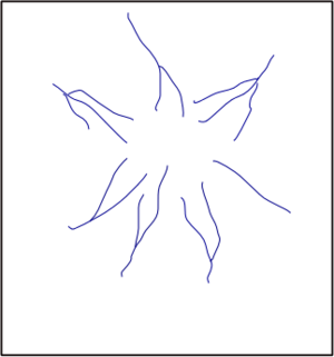
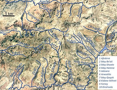
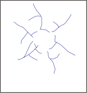
In a radial drainage system, streams flow outwards from a central high point, like the spokes of a wheel. This pattern often forms around volcanoes or dome-shaped hills. The streams spread out in many directions from the center.
Examples include the Amarkantak range in India and Dogu'a Tembien in Ethiopia.
Centripetal Drainage Pattern
A centripetal drainage pattern is the opposite of a radial pattern. Here, streams flow inwards and meet at a central low point, which is usually a basin or a depression. This creates an "inland drainage" system, meaning the water doesn't flow out to the ocean.
Deranged Drainage Pattern
A deranged drainage system has no clear or organized pattern to its rivers and lakes. It looks like a mess of streams and lakes without a main direction.
This can happen in areas with lots of limestone, where surface streams can disappear into underground caves. It also forms in places where the land has been greatly disturbed by geological events.
A good example is the Canadian Shield. During the last ice age, glaciers scraped away the topsoil, leaving mostly bare rock. When the glaciers melted, water collected in all the low spots, creating many lakes. The drainage systems here are still very new and are slowly trying to find a more stable pattern.
Annular Drainage Pattern
In an annular drainage pattern, streams follow a circular or ring-like path. This happens when streams flow along belts of weaker rock that form rings around a central dome or basin. As erosion wears away the land, layers of hard and soft rock are exposed, and the streams follow the softer layers.
This pattern can be seen in the Red Valley, which almost circles the Black Hills of South Dakota.
Angular Drainage Pattern
Angular drainage patterns form where cracks (joints) and faults in the bedrock meet at angles that are not exactly 90 degrees. These angles can be more or less than a right angle.
|
See also
 In Spanish: Red de drenaje para niños
- Distributary
- Integrated catchment management
- List of unusual drainage systems
- River bifurcation
- Stream capture
 | Lonnie Johnson |
 | Granville Woods |
 | Lewis Howard Latimer |
 | James West |


