Gooseberry River facts for kids
Quick facts for kids Gooseberry River |
|
|---|---|

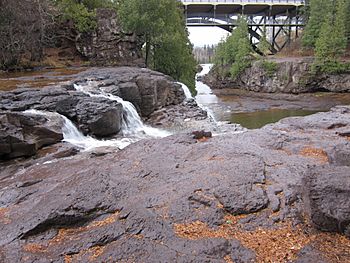
Gooseberry River at Upper Falls
|
|
|
Mouth of Gooseberry Rivere
|
|
| Country | United States |
| State | Minnesota |
| County | Lake County |
| Physical characteristics | |
| Main source | Legler Lake 1670 ft 47°17′47″N 91°37′17″W / 47.29639°N 91.62139°W |
| River mouth | Split Rock Point, Lake Superior 604 ft 47°08′34″N 91°27′25″W / 47.14278°N 91.45694°W |
| Length | 23 miles (37 km) |
| Basin features | |
| Basin size | 85 square miles (220 km2) |
The Gooseberry River is a 23-mile long stream. It flows through Lake County, Minnesota, in the United States. The river eventually empties into Lake Superior.
The Gooseberry River is famous for its beautiful waterfalls. These falls are located close to where the river meets Lake Superior. They are a main attraction in Gooseberry Falls State Park. Like many rivers nearby, the Gooseberry River's water level changes a lot. It depends on how much rain falls and how much snow melts. In the early 1900s, the area around the river was heavily forested. A lot of logging took place there. Today, the forest has grown back. The waterfalls and the river's mouth are now a very popular place for tourists to visit.
Contents
What's in a Name?
The name "Gooseberry River" first appeared on a map in 1823. This map was made by Major Stephen Harriman Long. He was exploring the border region between Canada and the U.S.
There are two main ideas about how the Gooseberry River got its name.
- One idea is that it comes from the Ojibwe language. The Ojibwe name for the river is shab-on-im-i-kan-i-sibi. This means "River Place of Gooseberries."
- Another idea is that the name is a translation of a French explorer's name. His name was Groseilliers. French maps from as early as 1670 showed the name Reviere de Groseilliers. Groseilliers visited the North Shore area in the 1660s.
No one knows for sure which story is true. The state park mentions both as possible explanations.
River Features and Flow
The Gooseberry River starts in a gully. It does not begin from a lake or a large water source. It starts at an elevation of about 1700 feet. From there, it drops about 1100 feet over its 23-mile journey. Finally, it flows into Lake Superior.
The main part of the Gooseberry River drains an area of 27.3 square miles. About a quarter of this area is wetlands, and three-quarters is forest. If you include all the smaller streams that flow into it, the river drains a total of 85 square miles. Some important smaller streams that join the Gooseberry River are the Little Gooseberry River, Skunk Creek, and Mink Creek.
Gooseberry Falls: A Natural Wonder
The most famous parts of the Gooseberry River are the Gooseberry Falls. These are three waterfalls located close together. You can find them near Highway 61 in Gooseberry Falls State Park.
- The first falls begin about 0.95 miles from the river's mouth. They are 120 feet above the level of Lake Superior.
- The falls end about 0.75 miles from the mouth, at 7 feet above lake level.
- Another waterfall is located between 1.8 and 1.85 miles from the mouth.
The riverbed near the falls is made of a hard rock called basalt. This basalt sits on top of a softer rock called amygdaloid. The amygdaloid wears away faster than the basalt. This causes large pieces of basalt to break off. This is how the high cliffs were formed, over which the river flows.
Below the falls, the river carves a large path through mostly clay. To the northeast, a tall basalt cliff rises 75 feet above the lake. To the southwest, there is a lower cliff, only 10 feet high. This lower cliff was probably once connected to the taller one. The river cut a channel between them.
At the mouth of the river, the river's flow meets the strong waves from Lake Superior. This creates a bar of red pebbles and pretty chalcedony agates.
River Flow Changes
Because the Gooseberry River doesn't start from a lake, its water level depends almost entirely on runoff. This means the river flows strongest during the spring. That's when snow melts and adds a lot of water. In the summer, the river can become very dry.
River Life: Plants and Animals
The Gooseberry River is home to different types of fish. You can find brook, brown, and rainbow trout in the parts of the river above the waterfalls. In April and May, steelhead fish also swim up the river.
The area around the river is a forest with a mix of evergreen trees, aspen, and birch trees. You can also find special Arctic–alpine plants here. These plants like the cooler climate near Lake Superior.
People and the River's History
French maps showed the Gooseberry River as the Reviere des Groseilliers as early as the 1670s. For a long time, the area remained mostly wild.
Logging and Railroads
In the 1870s, people started fishing in the North Shore region. Then, in the 1890s, loggers arrived. In 1899, two men, Colonel John H. Knight and former Senator William Freeman Vilas, bought land around the Gooseberry River. They paid $1,000,000 for it. They believed the land had a huge amount of pine trees. The logs cut from these forests were floated to their lumber mills in Ashland, Wisconsin.
A year later, in 1900, Thomas Nestor bought these lands and the mill. His company, the Nestor Logging Company, set up its main office at the mouth of the Gooseberry River. They built a railroad that went inland. This railroad helped them harvest the thick pine forests. The railway was removed by 1908. However, it was used again later to build a new track. This new track connected another logging project to the Duluth & Northern Minnesota Railway.
Small communities grew in the upper parts of the Gooseberry River's watershed. One town, London, was located where the Alger Line railroad crossed Dago Creek. A road for sleighs also ran alongside the railway. By the 1920s, most of the pine trees were gone due to logging and fires. The loggers moved away. The Alger Line stopped running in 1923, and London became a ghost town. Today, only foundations of buildings remain. The site is now part of local ghost stories.
Bridges and Parks
In 1922, a bridge was built over the Gooseberry River near the falls. This bridge was for Minnesota State Highway 61. This highway is the only one connecting to Canada along the North Shore. The first bridge was called Bridge no. 3585. It was made by the Illinois Steel Bridge Company. In 1937, a third arch was added to make the road wider.
By 1990, the bridge was getting old. A decision was made to replace it with a new arch bridge. The new bridge, #38010, looks similar to the original. After a different bridge collapsed in 2007, this new Gooseberry River bridge was checked. No major problems were found. The original bridge had an arch of 150 feet, and the modern bridge has an arch of 154 feet.
The area around the waterfalls was protected by law in 1933. In 1934, the Civilian Conservation Corps (CCC) started developing this land. They turned it into what is now Gooseberry Falls State Park. The park officially opened in 1937. CCC camps operated in the area from 1934 to 1941. They built more than 80 structures in the park. Today, the park welcomes over 600,000 visitors every year.
 | Anna J. Cooper |
 | Mary McLeod Bethune |
 | Lillie Mae Bradford |


