Temperance River facts for kids
Quick facts for kids Temperance River |
|
|---|---|

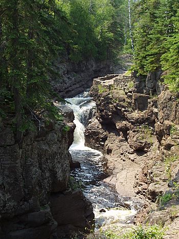
Temperance River at Temperance River State Park
|
|
|
Mouth of the Temperance River
|
|
| Country | United States |
| State | Minnesota |
| County | Cook County |
| Physical characteristics | |
| Main source | Brule Lake 47°55′42″N 90°46′54″W / 47.9282453°N 90.7817286°W |
| River mouth | Lake Superior 47°33′12″N 90°52′25″W / 47.5532°N 90.8735°W |
| Length | 39 miles (63 km) |
| Basin features | |
| Basin size | 198 square miles (510 km2) |
The Temperance River is a cool river in northern Minnesota, United States. It's about 39 miles (63 km) long. This river flows into Lake Superior on its north shore. You can find its mouth near Tofte. The river starts at Brule Lake in Cook County. It then flows south through Temperance River State Park. Its unique name might be a joke about how it doesn't have a sand bar at its mouth.
Contents
How the Temperance River Got Its Name
The Ojibwe people had a name for this river long ago. They called it Kawimbash. This name means "deep hollow river." It's a great description of parts of the river!
Later, in 1864, a person named Thomas Clark reported its current name. He said it was a funny play on words. The joke was that the river has no sand bar where it meets Lake Superior. A sand bar is a shallow area of sand. Many rivers have them at their mouths.
However, the Temperance River isn't the only river on Lake Superior without a sand bar. This makes some people wonder if that story is really true.
Exploring the River's Path
The Temperance River travels about 39 miles (63 km) from where it starts to where it ends. Its journey begins at Brule Lake. This lake is special because it has two places where water flows out.
Brule Lake's Unique Outlets
The Temperance River flows from the western outlet of Brule Lake. It carries about half of the water leaving the lake. The other half flows out of the eastern outlet, forming the South Brule River.
River's Journey and Features
For the first half of its length, the Temperance River flows through a series of smaller lakes. This is similar to nearby rivers like the Cross, Poplar, and Cascade rivers. Because of these lakes, the Temperance River's water is warmer. It also has a more steady flow than rivers further south.
After the lakes, the river flows directly over solid rock. This rock is igneous rock, which formed from cooled lava. It was created during a huge geological event called the Keweenawan Rift.
Deep Potholes and Waterfalls
Near Lake Superior, the river has carved deep holes into the bedrock. These holes are called potholes. Some of these potholes have connected over time. This created a narrow gorge and a series of beautiful waterfalls.
The water where the river enters Lake Superior is very deep. This depth is why the river doesn't form a sand bar at its mouth.
River Basin Size
The Temperance River has a drainage basin of about 198 square miles (513 square kilometers). A drainage basin is the area of land where all the water drains into a specific river. This makes it the fourth largest basin for a Minnesota river flowing into Lake Superior. Only the Saint Louis River, Pigeon River, and Brule River have larger basins.
 | Kyle Baker |
 | Joseph Yoakum |
 | Laura Wheeler Waring |
 | Henry Ossawa Tanner |


