Brule River (Minnesota) facts for kids
Quick facts for kids Brule River (Minnesota) |
|
|---|---|

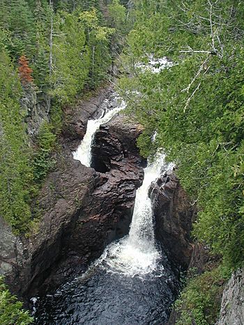
The Devil's Kettle
|
|
|
Mouth of the Brule River
|
|
| Country | United States |
| State | Minnesota |
| County | Cook County |
| Physical characteristics | |
| Main source | Hungry Jack Lake 48°00′25″N 90°28′20″W / 48.0068342°N 90.4723229°W |
| River mouth | Marr Island, Lake Superior 47°49′00″N 90°03′00″W / 47.8165587°N 90.0500980°W |
| Length | 40.4 miles (65.0 km) |
| Basin features | |
| Tributaries |
|
The Brule River is a cool river in the U.S. state of Minnesota. It starts in a wild area called the Boundary Waters Canoe Area Wilderness. This river flows for about 40 miles (65 km) before it reaches Lake Superior. It ends near a town called Grand Marais, Minnesota. The river runs through Judge C. R. Magney State Park.
Contents
What Does "Brule" Mean?
The name "Brule River" comes from the French language. It means "burnt." This name might have been given because of old forest fires in the area.
The Amazing Devil's Kettle
One of the most famous parts of the Brule River is a mysterious spot called "the Devil's Kettle." This is found inside Judge C. R. Magney State Park. At this spot, the river splits into two waterfalls.
One part of the waterfall goes over a cliff and continues flowing into Lake Superior. But the other part of the waterfall disappears into a giant hole in the rock. This hole is called a pothole.
Scientists have tried to figure out where the water goes. They have poured dyes into the hole. They have even dropped ping-pong balls and other items. But the water and items have never been seen again! It's a real puzzle.
Where Does the Brule River Start?
The Brule River begins at Vista Lake. This lake is in the Boundary Waters Canoe Area Wilderness. This is a very wild and beautiful part of Minnesota. The river then flows east and southeast.
A smaller river, called the South Brule River, also joins the main Brule River. The South Brule River starts at Brule Lake. This lake is also in the Boundary Waters area.
The Brule River and Lake Superior
After its long journey, the Brule River finally empties into Lake Superior. Lake Superior is the largest of the Great Lakes. The river's mouth is near Marr Island. This area is a beautiful place to visit.
 | Kyle Baker |
 | Joseph Yoakum |
 | Laura Wheeler Waring |
 | Henry Ossawa Tanner |


