
Judge C. R. Magney State Park facts for kids
Quick facts for kids Judge C. R. Magney State Park |
|
|---|---|

Devil's Kettle at Judge C. R. Magney State Park
|
|

Judge C. R. Magney State Park
Location in Minnesota

Judge C. R. Magney State Park
Location in the United States
|
|
| Location | Cook, Minnesota, United States |
| Area | 4,643 acres (18.79 km2) |
| Elevation | 1,073 ft (327 m) |
| Established | 1957 |
| Named for | Clarence R. Magney |
| Governing body | Minnesota Department of Natural Resources |
Judge C. R. Magney State Park is a special park in Minnesota, a state in the United States. It's located on the North Shore of Lake Superior. The park is named after Clarence R. Magney. He was a former mayor of Duluth and a judge on the Minnesota Supreme Court. He helped create many state parks along the North Shore.
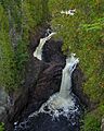
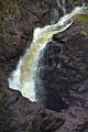
This park is famous for something called the Devil's Kettle. It's a very unusual waterfall and rock formation. At the Devil's Kettle, half of the Brule River seems to vanish into a deep hole in the rocks.
Contents
Park Location and Features
Judge C. R. Magney State Park is found along scenic Minnesota State Highway 61. It's about 25 miles (40 km) from the border with Canada. The last 8 miles (13 km) of the Brule River flows through the park. Along this path, the river drops 800 feet (240 m), creating many waterfalls.
The Brule River in the park has three named waterfalls. About 1 mile (1.6 km) from Lake Superior, you'll find Lower Falls. It drops 7 feet (2.1 m) over two steps. A bit further upstream are Upper Falls, which drop 25 feet (7.6 m). Then there's the famous Devil's Kettle Falls. The river flows through a rocky canyon in this area.
The park's northern part is wild and hard to reach. The land rises about 1,000 feet (300 m) from the river valley. This park is part of the Grand Portage State Forest. The weather here changes a lot with the seasons. Lake Superior makes the shore areas a bit warmer in winter and cooler in summer. This means winters are usually mild and snowy.
Nature in the Park
How the Land Was Formed
The park sits on layers of rock called basalt and rhyolite. These rocks formed about 1.1 billion years ago. This happened when the middle of the North American Plate started to crack. This crack created a huge basin that later filled with sedimentary rock.
About 2 million to 10,000 years ago, giant sheets of ice called glaciers covered this area many times. As the glaciers melted, they left behind rock and dirt. The meltwater filled the basin, forming a huge ancient lake called Glacial Lake Duluth. As the glaciers moved away, the lake levels changed. This left behind old beach ridges and terraces at different heights. You can see these landforms all along Minnesota's North Shore. Judge C. R. Magney State Park is special because it has all these different levels, from the highest ancient lake to the current Lake Superior level.
The Mystery of the Devil's Kettle

The park is most famous for the "Devil's Kettle." This unusual waterfall is on the Brule River. The river splits around a large rock. One part of the river flows over a 50-foot (15 m) waterfall and continues downstream. The other part rushes into a deep hole, falling at least 10 feet (3.0 m). For a long time, people thought this water just "disappeared underground."
Visitors would drop things like sticks, ping pong balls, and even GPS trackers into the Devil's Kettle. They never saw them come out downstream. There was even a wild story about a car being pushed into the hole! These stories made people wonder if the water went to a secret outlet into Lake Superior. Some even thought it went deep underground or to another river system entirely.
For many years, no one could explain the Devil's Kettle. It was a popular mystery in the region. Geologists knew the rocks here were not right for huge underground tunnels. Tunnels usually form in soft rocks like limestone. Also, there are no major faults (cracks in the Earth) in the area that could drain half a river.
However, in late 2016, scientists from the Minnesota Department of Natural Resources (DNR) found the answer. They measured the water flow above the falls and then several hundred feet below them. The measurements were almost exactly the same! This showed that no water was actually being lost to another outlet. The powerful currents inside the kettle's plunge pool are strong enough to hold down most objects until they break apart. So, the water simply flows back into the Brule River a short distance below the falls.
Plants and Animals
Judge C. R. Magney State Park has a wide variety of plants and animals. This is because the elevation changes a lot, about 1,000 feet (300 m). The park has a mixed forest with both conifer (like pine trees) and broadleaf trees. Long ago, the Brule River Valley was mostly covered in white pine trees. But logging and forest fires changed the park's plant life.
Today, the forest has many aspen and birch trees. You can also find white spruce, sugar maple, and basswood. Some old white pine trees still grow on hilltops and in ravines. Large northern white cedars are common along the river. Around the waterfalls, the constant mist creates a special small climate. This allows some unique plants to grow there.
Large animals in the park include white-tailed deer, moose, black bears, red foxes, and timber wolves. Smaller animals like groundhogs, red squirrels, and snowshoe hares also live here. Many raptors, like Broad-winged hawks and barred owls, live in the park or pass through during their migration. Several types of warblers also nest here. The Brule River is home to rainbow trout in spring and salmon in the fall.
White-tailed deer were not always common in northern Minnesota. They moved into the area when logging created new plant growth. Today, deer can sometimes eat too many young trees. To help new white pine trees grow, the park has put up fences to keep deer away from them.
Park History
The Ojibwe people called the river Wiskode-zibi, meaning "Half-burned Wood River." This name likely came from an early forest fire. Fires played a big part in the park's early history. In the late 1800s and early 1900s, many fires and droughts affected the North Shore.
In the 1920s, a group from Duluth planned to build a fancy resort called the Naniboujou Club. They wanted a huge lodge, cabins, and even a hydroelectric dam on the Brule River. The Naniboujou Club Lodge was finished in 1929. But then the Wall Street Crash of 1929 happened, starting the Great Depression. The rest of the resort was never built.
Instead of a resort, the future park became a place for men who had lost their homes during the Depression. In 1934, the state bought land and opened a "transient camp" on the Brule River. This camp gave work and housing to homeless men. It was first called the Grover Conzet Camp. Later, the federal Works Progress Administration took over.
About 800 men worked at the camp. They planted trees and built fire roads. They also created a small public park and built the trail and stairs that lead to the Devil's Kettle. The men received wages, medical care, and food. The concrete foundations of some of these camp buildings can still be seen in the park's campground today.
In 1957, the Minnesota Legislature created Brule River State Park. In 1963, the park was renamed Judge C. R. Magney State Park to honor Clarence Magney. The park was also made larger in 1965. Today, the park has a campground, a picnic area, and trails to the waterfalls.
Fun Things to Do
.jpg)
Most of the park's facilities are in the southern part. The campground is open in summer and has 27 sites with flush toilets and showers. The historic Naniboujou Club Lodge is privately owned and offers hotel rooms right across from the park entrance.
There are about nine miles (14 km) of hiking trails. The most popular hike is a challenging 1.1-mile (1.8 km) walk to the Devil's Kettle, Upper Falls, and Lower Falls. This trail has nearly 200 stairs. This route is part of the Superior Hiking Trail, which goes through the park.
The Brule River is a great place for fishing. The Minnesota Department of Natural Resources has been adding rainbow trout to the river since 1930. You can also find brook trout, chinook salmon, and pink salmon during their spawning seasons. Sometimes, anglers catch smallmouth bass and northern pike that have come from lakes upstream.
For experienced paddlers, the Brule River also offers exciting whitewater kayaking. Kayakers start upstream of the park and must carry their kayaks around certain parts of the river.
In Books and Movies
The Devil's Kettle has appeared in several stories. It's featured in the 1998 novel The Big Law by Chuck Logan. The 2009 movie Jennifer's Body shows a made-up version of the falls and a fictional town named after them. The Naniboujou Club Lodge and Devil's Kettle Falls are also in the 2009 book Sew Far, So Good by Monica Ferris.
In two novels by Minnesota author Peter Geye, The Lighthouse Road and Wintering, this waterfall is called The Devil's Maw. It plays an important role in the stories.
Images for kids
-
Devil's Kettle at Judge C. R. Magney State Park
-
The Devil's Kettle
-
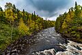
The Brule River in Judge C. R. Magney State Park
