Roseau County, Minnesota facts for kids
Quick facts for kids
Roseau County
|
|
|---|---|

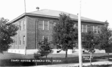
Postcard of the Roseau County Courthouse
|
|

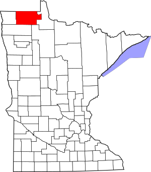
Location within the U.S. state of Minnesota
|
|
 Minnesota's location within the U.S. |
|
| Country | |
| State | |
| Founded | December 31, 1894 |
| Named for | Roseau River |
| Seat | Roseau |
| Largest city | Roseau |
| Area | |
| • Total | 1,678 sq mi (4,350 km2) |
| • Land | 1,672 sq mi (4,330 km2) |
| • Water | 6.5 sq mi (17 km2) 0.4%% |
| Population
(2020)
|
|
| • Total | 15,331 |
| • Estimate
(2023)
|
15,252 |
| • Density | 9.2/sq mi (3.6/km2) |
| Time zone | UTC−6 (Central) |
| • Summer (DST) | UTC−5 (CDT) |
| Congressional district | 7th |
Roseau County is a county in the northwestern part of Minnesota, a state in the United States. It is located right along the border with Canada.
In 2020, about 15,331 people lived here. The main town, where the county government is located, is called Roseau. Roseau County shares its northern border with the Canadian province of Manitoba. A part of the Red Lake Indian Reservation is also found within Roseau County.
Contents
History of Roseau County
Long, long ago, Roseau County was home to Native American tribes like the Ojibwe, Sioux, and Mandan. Archeologists have found old tools and items from these tribes that are up to 7,200 years old!
Later, explorers from Europe and fur trappers came to the area. By 1822, a place for trading furs was set up. In 1885, only four settlers lived in the area that would become Roseau City. But by 1895, about 600 people lived there, and it officially became Roseau City.
How Roseau County Was Formed
In the mid-1880s, people living in eastern Kittson County felt they were too far from their county seat. They asked the government for their own county.
So, on December 31, 1894, Governor Knute Nelson announced that the eastern part of Kittson County would become a new county named Roseau. A bit later, on February 11, 1896, Governor David Marston Clough added a piece of Beltrami County to Roseau County. Roseau City was chosen as the county seat, which is the main town for the county's government.
Geography of Roseau County
Roseau County is located in the very northern part of Minnesota. Its northern edge touches the country of Canada. The Roseau River flows through the upper part of the county. It then goes west into Kittson County and eventually reaches the Hudson Bay.
The land in Roseau County has gentle, rolling hills. Much of it is used for farming. You'll also find many lakes and small streams. There are also large wooded areas, especially in the southeastern part of the county. The county covers about 1,678 square miles. Most of this (1,672 square miles) is land, and a small part (6.5 square miles, or 0.4%) is water. Roseau is one of 17 counties in Minnesota that has more savanna soils than prairie or forest soils.
Transportation
Getting around Roseau County is possible by air and by road.
Airports
- Warroad International Memorial Airport (KRRT) - This airport is near the town of Warroad.
- Piney Pinecreek Border Airport - This airport actually stretches into Canada! It's a special airport where people can enter or leave the country.
Major Highways
These are the main roads that go through Roseau County:
 Minnesota State Highway 11
 Minnesota State Highway 32
 Minnesota State Highway 89
 Minnesota State Highway 308
 Minnesota State Highway 310
 Minnesota State Highway 313
Neighboring Areas
Roseau County is surrounded by other counties and areas:
- To the northwest: Rural Municipality of Stuartburn, Manitoba, Canada
- To the north: Rural Municipality of Piney, Manitoba, Canada
- To the northeast: Buffalo Point First Nation, Manitoba, Canada
- To the east: Lake of the Woods County
- To the southeast: Beltrami County
- To the south: Marshall County
- To the west: Kittson County
Protected Natural Areas
Roseau County has several protected areas where nature is preserved:
- Beltrami Island State Forest
- Hayes Lake State Park
- Lost River State Forest
- Luxemburg Peatland Scientific and Natural Area
- Roseau River State Wildlife Management Area
- Sprague Creek Peatland Scientific and Natural Area
- Two Rivers Aspen Park Scientific and Natural Area
Population of Roseau County
| Historical population | |||
|---|---|---|---|
| Census | Pop. | %± | |
| 1900 | 6,994 | — | |
| 1910 | 11,338 | 62.1% | |
| 1920 | 13,305 | 17.3% | |
| 1930 | 12,621 | −5.1% | |
| 1940 | 15,103 | 19.7% | |
| 1950 | 14,505 | −4.0% | |
| 1960 | 12,154 | −16.2% | |
| 1970 | 11,569 | −4.8% | |
| 1980 | 12,574 | 8.7% | |
| 1990 | 15,026 | 19.5% | |
| 2000 | 16,338 | 8.7% | |
| 2010 | 15,629 | −4.3% | |
| 2020 | 15,331 | −1.9% | |
| 2023 (est.) | 15,252 | −2.4% | |
| U.S. Decennial Census 1790-1960 1900-1990 1990-2000 2010-2020 |
|||
According to the 2020 census, the total population of Roseau County was 15,331 people. Most of the people living in Roseau County are White (89.4%). There are also smaller percentages of people who identify as Native American, Asian, Black or African American, or other races. About 1.6% of the population is Hispanic or Latino.
Communities in Roseau County
Roseau County has several towns and smaller communities.
Cities
- Badger
- Greenbush
- Roosevelt (part of this city is in Roseau County)
- Roseau (This is the county seat)
- Strathcona
- Warroad
Unincorporated Communities
These are smaller communities that are not officially organized as cities:
Ghost Towns
These are places where towns once existed but are now abandoned:
- Haug
- Winner
Townships
Townships are smaller local government areas within the county:
- Barnett Township
- Barto Township
- Beaver Township
- Cedarbend Township
- Deer Township
- Dewey Township
- Dieter Township
- Enstrom Township
- Falun Township
- Golden Valley Township
- Grimstad Township
- Hereim Township
- Huss Township
- Jadis Township
- Lake Township
- Laona Township
- Lind Township
- Malung Township
- Mickinock Township
- Moose Township
- Moranville Township
- Nereson Township
- Palmville Township
- Pohlitz Township
- Polonia Township
- Poplar Grove Township
- Reine Township
- Ross Township
- Skagen Township
- Soler Township
- Spruce Township
- Stafford Township
- Stokes Township
Unorganized Territories
These are areas within the county that do not have their own local government:
See also
 In Spanish: Condado de Roseau para niños
 | Kyle Baker |
 | Joseph Yoakum |
 | Laura Wheeler Waring |
 | Henry Ossawa Tanner |

