Elm Point, Minnesota facts for kids
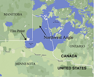
Elm Point, Minnesota, is a small piece of land in the United States that's almost completely surrounded by another country. It's like a small island of U.S. land, but it's connected to the mainland by a tiny strip. This makes it a "practical exclave" of the U.S. It's located in Roseau County, Minnesota.

Elm Point is surrounded by Lake of the Woods on its west, south, and east sides. To the north, it borders a Canadian First Nation community called Buffalo Point First Nation in Manitoba.
Part of Elm Point is owned by private citizens. The other part is state land. The Minnesota Department of Natural Resources manages this state land. It is part of the Border Wildlife Management Area. Elm Point is southwest of a much larger U.S. exclave called the Northwest Angle.
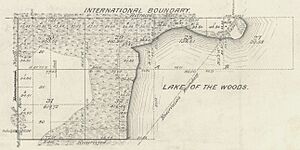
You can see a line of cut trees that marks the international border. This border usually follows the 49th parallel (a line of latitude). However, in this area, it runs a little bit south of the 49th parallel. This is because of some mistakes made during the original land surveying in the 1800s.
Besides Elm Point, there are a few other small areas of U.S. land nearby. These are west of Elm Point but east of the main part of Minnesota. They extend up to 300 feet (about 91 meters) south of the border. One of these small areas is called Buffalo Bay Point.
Why is Elm Point's Location Confusing?
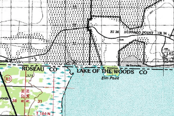
There has been some confusion about which county Elm Point belongs to. Some maps, like those from the United States Census Bureau, show it in Lake of the Woods County. The Minnesota Department of Transportation also publishes maps that place it there.
However, people who own land in Elm Point pay their property taxes to Roseau County. Also, the mapping system for Lake of the Woods County doesn't show any property details for Elm Point. An old state map from 1916 shows Elm Point as part of Roseau County.
The confusion likely started with a special announcement from Governor David Marston Clough. On February 10, 1896, he announced that the area would be added to Roseau County. The description of the new border was a bit tricky. It said the border would go east along the Canadian border "to the Lake of the Woods; thence easterly, following the south meandered shore of said Lake of the Woods."
From where the Canadian border meets Lake of the Woods, the shoreline actually goes west around Elm Point first. Then it turns south before going east. This made the description in the announcement a bit unclear.
But the announcement also said that the area being added included "Township 164 North, Range 36 West." It also stated that its borders followed the official U.S. survey lines for townships. This was required by law at the time. Elm Point is definitely located within Township 164 North, Range 36 West. This helps confirm it belongs to Roseau County.
See also
 In Spanish: Elm Point para niños
 | William M. Jackson |
 | Juan E. Gilbert |
 | Neil deGrasse Tyson |


