
Brainerd, Minnesota facts for kids
Quick facts for kids
Brainerd
|
||
|---|---|---|

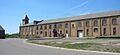
Northern Pacific Railroad Shops Historic District
|
||
|
||

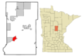
Location within Crow Wing County
|
||

Brainerd, Minnesota
Location in Minnesota

Brainerd, Minnesota
Location in the United States
|
||
| Country | United States | |
| State | Minnesota | |
| County | Crow Wing | |
| Founded | 1870 | |
| Incorporated | March 6, 1873 | |
| Area | ||
| • Total | 12.82 sq mi (33.21 km2) | |
| • Land | 12.13 sq mi (31.42 km2) | |
| • Water | 0.69 sq mi (1.79 km2) 5.78% | |
| Elevation | 1,217 ft (371 m) | |
| Population
(2020)
|
||
| • Total | 14,395 | |
| • Estimate
(2022)
|
14,580 | |
| • Density | 1,186.73/sq mi (458.20/km2) | |
| Time zone | UTC-6 (Central) | |
| • Summer (DST) | UTC-5 (CDT) | |
| ZIP code |
56401
|
|
| Area code(s) | 218 | |
| FIPS code | 27-07300 | |
| GNIS feature ID | 2394238 | |

Brainerd is a city in Minnesota, United States. It is the main city of Crow Wing County. In 2020, about 14,395 people lived there. Brainerd is located along the Mississippi River. It is known for being part of the 1996 movie Fargo.
Contents
History of Brainerd
Early Days and Founding
The land where Brainerd now stands was first home to the Ojibwe people. The first European visitor was Zebulon Pike in 1805. He was looking for the start of the Mississippi River. Later, a community called Crow Wing Village grew nearby. It was a place for fur trading and logging.
Brainerd was started in 1870 by John Gregory Smith. He was the president of the Northern Pacific railroad. He named the town after his wife, Anne Eliza Brainerd Smith. The railroad built a bridge over the Mississippi River. This made many people move from Crow Wing Village to Brainerd. Brainerd officially became a city on March 6, 1873.
The Blueberry War
In 1872, there was a misunderstanding called the "Blueberry War." Two Ojibwe men were accused of a crime. When a group of Ojibwe approached the town, people thought there might be trouble. Soldiers from a nearby fort were called. But it turned out the Ojibwe only wanted to sell blueberries. Everyone avoided a conflict. The guilt of the two Ojibwe men was never proven.

Railroad and Industry
The railroad helped Brainerd grow a lot in 1881. For many years, Brainerd was a "railroad town." About 90% of its people worked for the railroad in the 1920s.
In 1933, a famous bank robber named Baby Face Nelson held up the First National Bank of Brainerd.
Over time, the railroad's importance in Brainerd lessened. But the BNSF Railway still has about 70 workers in Brainerd. They fix and maintain railroad equipment.
The Northwest Paper Company built Brainerd's first paper mill in 1903. Today, paper making and tourism are the main jobs in Brainerd. Many new buildings are now built in the nearby city of Baxter.
Geography of Brainerd
Brainerd is in the middle of Minnesota. It is built on both sides of the Mississippi River. The older parts of the city are mostly on the east side.
Lakes Area
Brainerd itself does not have many lakes. But there are over 460 lakes within 25 miles (40 km) of the city. Most of these lakes are to the north. Because of this, the area around Brainerd is often called the Brainerd Lakes Area.
The city covers about 12.64 square miles (32.74 square kilometers). About 11.91 square miles (30.85 square kilometers) is land, and 0.73 square miles (1.89 square kilometers) is water.
Main Roads
Several important roads pass through the Brainerd area:
 Minnesota State Highway 18
 Minnesota State Highway 25
 Minnesota State Highway 210
 Minnesota State Highway 371
People of Brainerd
Population Changes
| Historical population | |||
|---|---|---|---|
| Census | Pop. | %± | |
| 1880 | 1,865 | — | |
| 1890 | 5,703 | 205.8% | |
| 1900 | 7,524 | 31.9% | |
| 1910 | 8,526 | 13.3% | |
| 1920 | 9,591 | 12.5% | |
| 1930 | 10,221 | 6.6% | |
| 1940 | 12,071 | 18.1% | |
| 1950 | 12,087 | 0.1% | |
| 1960 | 12,898 | 6.7% | |
| 1970 | 11,667 | −9.5% | |
| 1980 | 11,489 | −1.5% | |
| 1990 | 12,353 | 7.5% | |
| 2000 | 13,178 | 6.7% | |
| 2010 | 13,590 | 3.1% | |
| 2020 | 14,395 | 5.9% | |
| 2022 (est.) | 14,580 | 7.3% | |
| U.S. Decennial Census 2020 Census |
|||
In 2020, Brainerd had a population of 14,395 people. Most residents were White (88.6%). Other groups included Native American (2.2%), Black (1.6%), and Asian (0.7%). About 2.5% of the population was Hispanic or Latino.
In 2010, there were 13,590 people living in Brainerd. The average age was about 32 years old. About 24.5% of the people were under 18.
Arts and Culture in Brainerd
The Brainerd Lakes Area hosts a classical music festival in the summer. It is called the Lakes Area Music Festival. This festival brings talented musicians from all over the world. They perform concerts that are free for everyone to enjoy. The festival also has special programs for children. They help bring classical music to places like libraries and retirement homes.
Education in Brainerd
Brainerd has its own school district called Brainerd Public Schools. The main high school is Brainerd High School. There are also other schools, including a charter school and a Catholic school.
For older students, Central Lakes College is a local college. It offers associate degrees and technical certificates.
Media in Brainerd
Brainerd has many radio stations. You can listen to different types of music like country, classical, and adult contemporary. There are also news and talk radio stations.
The area also has television channels. These include stations that show programs from ABC, FOX, and PBS.
Travel and Transportation
Major Highways
The main roads that go through Brainerd are:
- Minnesota State Highway 18
- Minnesota State Highway 25
- Minnesota State Highway 210
- Minnesota State Highway 371
Airport
The Brainerd Lakes Regional Airport serves the area. It has flights for people and also for cargo (goods).
Famous People from Brainerd
Many interesting people have come from Brainerd, including:
- Solomon Flagg Alderman (1861–1928), a state senator and lawyer.
- John Carlton Atherton (1900–1952), an artist.
- Roger Awsumb (1928–2002), a TV and radio show host.
- Bullet Joe Bush (1892–1974), a baseball player who won the World Series with the New York Yankees.
- Joe Haeg (born 1993), a professional football player.
- Rick Nolan (1943-2024), a U.S. Representative.
Images for kids
-
Northern Pacific Railroad Shops Historic District
-
Location within Crow Wing County
-
Brainerd City Seal
See also
 In Spanish: Brainerd (Minnesota) para niños
