
Motley, Minnesota facts for kids
Quick facts for kids
Motley, Minnesota
|
|
|---|---|

Water tower
|
|

Location in Morrison County and the state of Minnesota
|
|
| Country | United States |
| State | Minnesota |
| Counties | Morrison, Cass |
| Area | |
| • Total | 1.45 sq mi (3.75 km2) |
| • Land | 1.39 sq mi (3.60 km2) |
| • Water | 0.06 sq mi (0.16 km2) |
| Elevation | 1,227 ft (374 m) |
| Population
(2020)
|
|
| • Total | 680 |
| • Density | 489.91/sq mi (189.10/km2) |
| Time zone | UTC-6 (Central (CST)) |
| • Summer (DST) | UTC-5 (CDT) |
| ZIP code |
56466
|
| Area code(s) | 218 |
| FIPS code | 27-44422 |
| GNIS feature ID | 2395418 |
Motley is a small city in the state of Minnesota, USA. It is located in two different counties: Morrison County and Cass County. Most of Motley is in Morrison County.
In 2020, about 680 people lived in Motley. The part of Motley that is in Cass County is also close to the larger area around Brainerd.
Contents
History of Motley
Motley was first planned out in 1874. Before that, a post office had already opened in Motley in 1873.
In 1881, the Northern Pacific Railway built a train station here. It was 20 feet by 40 feet and used for passengers. They also built a larger 24-foot by 60-foot building for freight. A special train track, called a spur line, went from the main railway south to a wood mill. This mill was located near the Long Prairie River. The spur line was removed by 1920.
Geography and Location
Motley is in the northwest part of Morrison County. A small piece of the city also reaches into Cass County. The city is surrounded by different townships. To the south is Motley Township. To the east and north is May Township. To the west is Villard Township in Todd County.
Main Roads and Rivers
Several important roads pass through Motley. These include U.S. Highway 10, Highway 64, and Highway 210.
- US 10 goes southeast about 30 miles to Little Falls. This is the main town for Morrison County. US 10 also goes west-northwest about 25 miles to Wadena.
- Highway 210 goes east about 22 miles to Brainerd. It also goes west from Motley with US 10 for a bit, then splits off to go west about 22 miles to Hewitt.
- Highway 64 goes north from Motley about 49 miles to Akeley.
Motley covers about 1.45 square miles in total. Most of this area is land (1.39 square miles), and a small part is water (0.06 square miles). The Crow Wing River flows through Motley, north and east of the city center. This river forms the border between Morrison and Cass counties. It flows east to join the Mississippi River near Brainerd. The Long Prairie River also flows into the Crow Wing River. It forms part of Motley's southwest border.
Population of Motley
| Historical population | |||
|---|---|---|---|
| Census | Pop. | %± | |
| 1880 | 199 | — | |
| 1890 | 525 | 163.8% | |
| 1900 | 404 | −23.0% | |
| 1910 | 428 | 5.9% | |
| 1920 | 396 | −7.5% | |
| 1930 | 397 | 0.3% | |
| 1940 | 368 | −7.3% | |
| 1950 | 435 | 18.2% | |
| 1960 | 430 | −1.1% | |
| 1970 | 351 | −18.4% | |
| 1980 | 444 | 26.5% | |
| 1990 | 441 | −0.7% | |
| 2000 | 585 | 32.7% | |
| 2010 | 671 | 14.7% | |
| 2020 | 680 | 1.3% | |
| U.S. Decennial Census | |||
In 2010, there were 671 people living in Motley. There were 305 households, which are groups of people living in one home. The city had about 504 people per square mile. There were 338 housing units, like houses or apartments.
The average age of people in Motley in 2010 was 41.1 years old. About 23.5% of the people were under 18 years old. About 21.6% were 65 years old or older. The city had slightly more females (51.4%) than males (48.6%).
Gallery
-
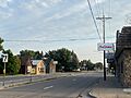
Hwy 10 at Beaulieu Street, looking south
-
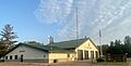
Fire Department
-
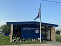
Post Office


See also
 In Spanish: Motley (Minnesota) para niños
