Bois de Sioux River facts for kids
Quick facts for kids Bois de Sioux River |
|
|---|---|

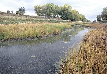
The Bois de Sioux River below the dam of Lake Traverse. Roberts County, South Dakota is at left, and Traverse County, Minnesota is at right.
|
|

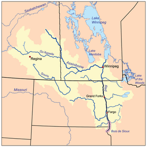
Red River drainage basin, with Bois de Sioux River highlighted
|
|
| Physical characteristics | |
| Main source | Dam at the foot of Lake Traverse, South Dakota 45°51′42″N 96°34′23″W / 45.8616667°N 96.5730556°W |
| River mouth | Confluence with the Otter Tail River to form the Red River 951 ft (290 m) 46°15′52″N 96°35′55″W / 46.2644444°N 96.5986111°W |
| Length | 41 mi (66 km) |
| Basin features | |
| Progression | Bois de Sioux River → Red River → Lake Winnipeg → Nelson River → Hudson Bay → Atlantic Ocean |
| GNIS ID | 640348 |
The Bois de Sioux River is a unique river in North America. It flows out of Lake Traverse, which is the southernmost body of water in the huge Hudson Bay watershed. A watershed is like a giant funnel where all the rain and snow eventually drain into one main river or lake. This river is a tributary of the Red River of the North, meaning it's a smaller river that flows into a bigger one.
The Bois de Sioux River also forms part of the western border of the U.S. state of Minnesota. It also makes up parts of the eastern borders of North Dakota and South Dakota. It is about 41 miles (66 km) long.
Contents
About the Bois de Sioux River
The Bois de Sioux River starts its journey from Lake Traverse. This lake is important because its waters eventually make their way to Hudson Bay in Canada. This long journey shows how connected our planet's water systems are.
Where Does It Flow?
As the Bois de Sioux River flows north, it creates a natural boundary. It separates Minnesota on its eastern side from North Dakota and South Dakota on its western side. Imagine the river as a line drawn on a map, marking where one state ends and another begins!
How the Red River is Formed
The Bois de Sioux River doesn't just flow on its own forever. It meets another river called the Otter Tail River. When these two rivers join together, they form the famous Red River of the North. This meeting point is called a confluence. It's like two paths coming together to make a bigger road.
Its Special Name
The Dakota people have a special name for this river: Caninkpa Wakpa. This name means "wood point river." It was given this name because the river marks the beginning of the woods that stretch all the way to Hudson Bay. This name tells us a lot about the land and its history.
 | Chris Smalls |
 | Fred Hampton |
 | Ralph Abernathy |

