Norman County, Minnesota facts for kids
Quick facts for kids
Norman County
|
|
|---|---|

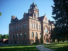
Norman County Courthouse in Ada, Minnesota
|
|

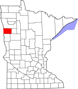
Location within the U.S. state of Minnesota
|
|
 Minnesota's location within the U.S. |
|
| Country | |
| State | |
| Founded | February 17, 1881 |
| Named for | Norwegian settlers |
| Seat | Ada |
| Largest city | Ada |
| Area | |
| • Total | 877 sq mi (2,270 km2) |
| • Land | 873 sq mi (2,260 km2) |
| • Water | 3.9 sq mi (10 km2) 0.4%% |
| Population
(2020)
|
|
| • Total | 6,441 |
| • Estimate
(2023)
|
6,329 |
| • Density | 7.4/sq mi (2.9/km2) |
| Time zone | UTC−6 (Central) |
| • Summer (DST) | UTC−5 (CDT) |
| Congressional district | 7th |
Norman County is a county located in the northwestern part of the U.S. state of Minnesota. It's known for its beautiful natural areas and friendly communities. In 2020, about 6,441 people lived here. The main town and county seat is Ada. This county is part of Minnesota's Red River Valley region.
Contents
History of Norman County
How Norman County Was Formed
People from Norway started settling in this area in the early 1870s. The Minnesota government officially created Norman County on March 17, 1881. The town of Ada, which was founded in 1874, was chosen as the county seat. This means Ada became the main town where the county government operates.
Why the Name "Norman"?
The county was named "Norman" to honor the many settlers who came from Scandinavian countries, especially Norway. Another idea is that it was named after Norman Kittson, an important person in the region's early history.
Geography and Nature
Where is Norman County?
Norman County is right on Minnesota's western border. It sits next to North Dakota, with the Red River flowing north along its western edge. This river actually forms part of the county's border!
Rivers and Land Features
The Wild Rice River flows west through the lower part of the county. The Marsh River starts in the middle of Norman County and flows northwest. The land here has gentle, rolling hills. You'll also find some small lakes and swampy areas. Most of the land is used for farming.
There's a special hill called Frenchman's Bluff in Flom Township. It rises about 150 feet (46 meters) above the land around it.
Main Roads in Norman County
If you're driving through Norman County, you'll find these important highways:
 U.S. Highway 75
 Minnesota State Highway 9
 Minnesota State Highway 32
 Minnesota State Highway 113
 Minnesota State Highway 200
Neighboring Counties
Norman County shares its borders with several other counties:
- Polk County - to the north
- Mahnomen County - to the east
- Becker County - to the southeast
- Clay County - to the south
- Cass County, North Dakota - to the southwest
- Traill County, North Dakota - to the west
Protected Natural Areas
Norman County has many special places that are protected to keep nature safe. These include:
- Agassiz Dunes Scientific and Natural Area (part)
- Agassiz No. 1 State Wildlife Management Area
- Agassiz No. 2 State Wildlife Management Area
- Dalby State Wildlife Management Area
- Faith State Wildlife Management Area
- Home Lake State Wildlife Management Area
- Moccasin State Wildlife Management Area
- Neal State Wildlife Management Area
- Prairie Smoke Dunes Scientific and Natural Area
- Sandpiper Scientific and Natural Area
- Santee Prairie Scientific and Natural Area
- Syre State Wildlife Management Area
- Twin Valley Prairie Scientific and Natural Area
- Twin Valley State Wildlife Management Area
- Vangsness State Wildlife Management Area
Lakes in the County
You can find these lakes in Norman County:
- Home Lake
- Lockhart Swamp
Population and People
How Many People Live Here?
Every ten years, the United States counts its population in what's called a census. This helps us understand how many people live in different areas. Here's how Norman County's population has changed over the years:
| Historical population | |||
|---|---|---|---|
| Census | Pop. | %± | |
| 1890 | 10,618 | — | |
| 1900 | 15,045 | 41.7% | |
| 1910 | 13,446 | −10.6% | |
| 1920 | 14,880 | 10.7% | |
| 1930 | 14,061 | −5.5% | |
| 1940 | 14,746 | 4.9% | |
| 1950 | 12,909 | −12.5% | |
| 1960 | 11,253 | −12.8% | |
| 1970 | 10,008 | −11.1% | |
| 1980 | 9,379 | −6.3% | |
| 1990 | 7,975 | −15.0% | |
| 2000 | 7,442 | −6.7% | |
| 2010 | 6,852 | −7.9% | |
| 2020 | 6,441 | −6.0% | |
| 2023 (est.) | 6,329 | −7.6% | |
| U.S. Decennial Census 1790-1960 1900-1990 1990-2000 2010-2020 |
|||
As of 2020, the population was 6,441 people. The county's population has slowly decreased over the last few decades.
Communities in Norman County
Cities You Can Visit
Norman County has several cities, each with its own unique charm:
Smaller Communities (Unincorporated)
These are smaller places that aren't officially cities:
Townships in the County
A township is a small area of land, often with its own local government. Norman County has many townships:
- Anthony Township
- Bear Park Township
- Flom Township
- Fossum Township
- Good Hope Township
- Green Meadow Township
- Halstad Township
- Hegne Township
- Hendrum Township
- Home Lake Township
- Lake Ida Township
- Lee Township
- Lockhart Township
- Mary Township
- McDonaldsville Township
- Pleasant View Township
- Rockwell Township
- Shelly Township
- Spring Creek Township
- Strand Township
- Sundal Township
- Waukon Township
- Wild Rice Township
- Winchester Township
See also
 In Spanish: Condado de Norman para niños
 | Dorothy Vaughan |
 | Charles Henry Turner |
 | Hildrus Poindexter |
 | Henry Cecil McBay |

