Mahnomen County, Minnesota facts for kids
Quick facts for kids
Mahnomen County
|
|
|---|---|

|
|

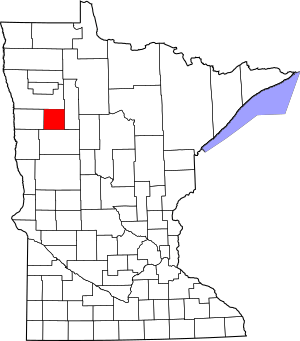
Location within the U.S. state of Minnesota
|
|
 Minnesota's location within the U.S. |
|
| Country | |
| State | |
| Founded | December 27, 1906 |
| Named for | Ojibway word for wild rice |
| Seat | Mahnomen |
| Largest city | Mahnomen |
| Area | |
| • Total | 583 sq mi (1,510 km2) |
| • Land | 558 sq mi (1,450 km2) |
| • Water | 25 sq mi (60 km2) 4.3%% |
| Population
(2020)
|
|
| • Total | 5,411 |
| • Estimate
(2023)
|
5,280 |
| • Density | 9.7/sq mi (3.7/km2) |
| Time zone | UTC−6 (Central) |
| • Summer (DST) | UTC−5 (CDT) |
| Congressional district | 7th |
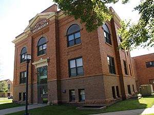
Mahnomen County is a county in the U.S. state of Minnesota. In 2020, about 5,411 people lived there. The main town and county seat is Mahnomen.
This county is special because it is entirely inside the White Earth Indian Reservation. It is the only county in Minnesota that is completely within an Indian reservation. Mahnomen County, along with parts of East Polk and Becker counties, is a big area for raising cattle in northwestern Minnesota.
Contents
The Story of Mahnomen County
Mahnomen County was created on December 27, 1906. It was formed from the eastern part of Norman County. The town of Mahnomen, which used to be a railway stop, became the county seat.
The county got its name from the town. The word "Mahnomen" is one way to spell an Ojibwe word that means "wild rice." A long time ago, from 1857 to 1858, there was another county in Minnesota called Manomin County. It later joined with Anoka County.
Where is Mahnomen County?
The Wild Rice River flows into Mahnomen County from Clearwater County. It then travels west through the middle of the county. The White Earth River starts at White Earth Lake, which is on the county's southern border. It flows northwest and meets the Wild Rice River near Mahnomen.
The land in the county has gentle rolling hills and valleys carved by rivers. The eastern part of the county has many lakes and ponds and is mostly covered in woods. Any areas that are not wooded are used for farming. The county slopes down towards the west and north. Its highest point is in the middle of the eastern border, about 1,825 feet (556 meters) above sea level.
Mahnomen County covers about 583 square miles (1,510 square kilometers). Of this, 558 square miles (1,445 square kilometers) is land, and 25 square miles (65 square kilometers) is water. This means about 4.3% of the county is water. Mahnomen is one of 17 counties in Minnesota that has more savanna soils than prairie or forest soils.
Main Roads in Mahnomen County
 U.S. Highway 59
 Minnesota State Highway 113
 Minnesota State Highway 200
Local Airports
- Mahnomen County Airport (3N8) is located south of Mahnomen.
Neighboring Counties
- Polk County - to the north
- Clearwater County - to the east
- Becker County - to the south
- Norman County - to the west
Protected Natural Areas
There are several protected areas in Mahnomen County where wildlife can thrive:
- Beaulife State Wildlife Management Area
- Bejou State Wildlife Management Area
- Budde Meadow State Wildlife Management Area
- Dittmer State Wildlife Management Area
- Foot State Wildlife Management Area
- Hasselton State Wildlife Management Area (part)
- Loncrace State Wildlife Management Area
- Mahgre State Wildlife Management Area
- Rush Lake State Wildlife Management Area
- Santee Prairie Scientific and Natural Area
- Wambach State Wildlife Management Area
- Warren Lake State Wildlife Management Area
Who Lives in Mahnomen County?
| Historical population | |||
|---|---|---|---|
| Census | Pop. | %± | |
| 1910 | 3,249 | — | |
| 1920 | 6,197 | 90.7% | |
| 1930 | 6,153 | −0.7% | |
| 1940 | 8,054 | 30.9% | |
| 1950 | 7,059 | −12.4% | |
| 1960 | 6,341 | −10.2% | |
| 1970 | 5,638 | −11.1% | |
| 1980 | 5,535 | −1.8% | |
| 1990 | 5,044 | −8.9% | |
| 2000 | 5,190 | 2.9% | |
| 2010 | 5,413 | 4.3% | |
| 2020 | 5,411 | 0.0% | |
| 2023 (est.) | 5,280 | −2.5% | |
| U.S. Decennial Census 1790-1960 1900-1990 1990-2000 2010-2020 |
|||
The population of Mahnomen County has changed over the years. In 2020, the census counted 5,411 people living there.
2020 Census Information
The 2020 census showed the different groups of people living in Mahnomen County:
| Race | Number of People | Percentage |
|---|---|---|
| White (not Hispanic) | 2,278 | 42.1% |
| Black or African American (not Hispanic) | 8 | 0.1% |
| Native American (not Hispanic) | 2,256 | 41.7% |
| Asian (not Hispanic) | 7 | 0.13% |
| Pacific Islander (not Hispanic) | 0 | 0.% |
| Other/Mixed (not Hispanic) | 708 | 13.1% |
| Hispanic or Latino | 154 | 2.84% |
Towns and Communities
Mahnomen County has several towns and communities where people live.
Cities
Census-Designated Places (CDPs)
These are areas that are like towns but are not officially incorporated as cities.
- Beaulieu
- Midway
- Naytahwaush
- Pine Bend
- Riverland
- Roy Lake
- The Ranch
- Twin Lakes
- West Roy Lake
Unincorporated Community
Townships
Townships are smaller local government areas within the county.
- Beaulieu Township
- Bejou Township
- Chief Township
- Clover Township
- Gregory Township
- Heier Township
- Island Lake Township
- La Garde Township
- Lake Grove Township
- Little Elbow Township
- Marsh Creek Township
- Oakland Township
- Pembina Township
- Popple Grove Township
- Rosedale Township
- Twin Lakes Township
See also
 In Spanish: Condado de Mahnomen para niños
 | Leon Lynch |
 | Milton P. Webster |
 | Ferdinand Smith |

