Anoka County, Minnesota facts for kids
Quick facts for kids
Anoka County
|
|
|---|---|

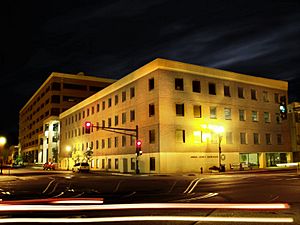
The Anoka County Courthouse and Government Center in downtown Anoka, July 2009
|
|

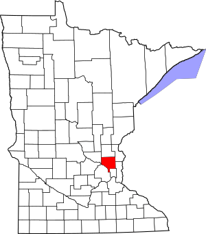
Location within the U.S. state of Minnesota
|
|
 Minnesota's location within the U.S. |
|
| Country | |
| State | |
| Founded | May 23, 1857 |
| Named for | City of Anoka |
| Seat | Anoka |
| Largest city | Blaine |
| Area | |
| • Total | 446 sq mi (1,160 km2) |
| • Land | 423 sq mi (1,100 km2) |
| • Water | 23 sq mi (60 km2) 5.2%% |
| Population
(2020)
|
|
| • Total | 363,887 |
| • Estimate
(2023)
|
372,441 |
| • Density | 862/sq mi (333/km2) |
| Time zone | UTC−6 (Central) |
| • Summer (DST) | UTC−5 (CDT) |
| Congressional districts | 3rd, 5th, 6th |
Anoka County (/əˈnoʊkə/ ə-NOH-kə) is a county in the state of Minnesota. It is the fourth-most populated county in Minnesota. As of the 2020 census, about 363,887 people lived there.
The main city and namesake of the county is Anoka. The name "Anoka" comes from a Dakota word. It means "on (or from) both sides." This refers to the city's location on both banks of the Rum River. The biggest city in the county is Blaine. It is the tenth-largest city in Minnesota. It is also the sixth-largest suburb in the Twin Cities area.
Anoka County is in the northern part of the Minneapolis–Saint Paul area. This is the largest group of cities and towns in Minnesota. About 3.64 million people live in this large area. The county is next to several other counties. These include Isanti to the north and Hennepin to the southwest. The Rum River flows through the county. It was an important route for early European settlers. It was also a common path to Mille Lacs Lake. This lake is a special place for the Ojibwe people.
The area became a center for fur trading and logging. French and French Canadian communities grew in cities like Anoka and Centerville. Anoka County was officially started in 1857. Over time, it became a mostly suburban area. This happened after Interstate 35W was built. Today, the county has fun places to visit. These include the Heights Theater in Columbia Heights. There is also Northtown Mall and the National Sports Center in Blaine.
Contents
History
Anoka County was officially started on May 23, 1857. This was one year before Minnesota became a state. It was formed from parts of Ramsey County and Benton County. The Rum River used to be the border between these two counties.
The county's borders are mostly the same today. However, a small part in the southeast changed. This area was once called Manomin County. It was a very small county. It joined Anoka County in 1869. This area later became known as Fridley in 1879.
The first Europeans to explore this area were Louis Hennepin and his group. Soon after, fur traders began to settle near the Rum River. More people came to the area that is now Anoka.
Geography
Anoka County covers about 446 square miles. About 23 square miles of this area is water. The Mississippi River flows along the county's southwestern edge. The Rum River flows south through the western part of the county. It joins the Mississippi River at the county's southwest border.
The land in Anoka County has low, rolling, wooded hills. The land generally slopes towards the south and east. The highest point is about 1,100 feet above sea level. This spot is east of the county's northwest corner.
Lakes
Anoka County has many lakes. Here are some of them:
- Baldwin Lake
- Bunker Lake
- Cedar Lake
- Centerville Lake
- Coon Lake
- Crooked Lake
- George Watch Lake
- Golden Lake
- Ham Lake
- Laddie Lake
- Lake George
- Marshan Lake
- McKay Lake
- Moore Lake
- Peltier Lake
- Reshanau Lake
- Rice Lake
- Round Lake
- Sherman Lake
- Spring Lake
- Smith Lake
- Wards Lake
Waterways
Besides the major rivers, many smaller streams flow through the county:
- Cedar Creek
- Coon Creek
- Crooked Brook
- Ford Brook
- Hardwood Creek
- Mahoney Brook
- Mississippi River
- Rice Creek
- Rum River
- Sand Creek
- Seelye Brook
- Trott Brook
- Pheasant creek
Major Highways
Several important highways pass through Anoka County:
 Interstate 35
 Interstate 35E
 Interstate 35W
 Interstate 694
 US Highway 10
 US Highway 169
 Minnesota State Highway 47
 Minnesota State Highway 65
 Minnesota State Highway 97
 Minnesota State Highway 610
- List of county roads
Neighboring Counties
Anoka County shares borders with these counties:
- Isanti County - north
- Chisago County - northeast
- Washington County - east
- Ramsey County - southeast
- Hennepin County - southwest
- Sherburne County - northwest
Protected Areas
Anoka County has several parks and natural areas. These places help protect wildlife and nature:
- Bethel Wildlife Management Area
- Boot Lake Scientific and Natural Area
- Bunker Hills Regional Park
- Carl E Bonnell Wildlife Management Area
- Carlos Avery State Wildlife Management Area
- Cedar Creek Conservation Area
- Coon Rapids Dam Regional Park
- East Bethel Booster Park
- Gordie Mikkelson Wildlife Management Area
- Helen Allison Savanna Scientific and Natural Area
- Lake George Regional Park
- Martin Island-Linwood Lakes Regional Park
- Mississippi National River and Recreation Area (part)
- Rice Creek Chain of Lakes Park Preserve
- Robert and Marilyn Burman Wildlife Management Area
Climate and Weather
| Weather chart for Anoka, Minnesota | |||||||||||||||||||||||||||||||||||||||||||||||
|---|---|---|---|---|---|---|---|---|---|---|---|---|---|---|---|---|---|---|---|---|---|---|---|---|---|---|---|---|---|---|---|---|---|---|---|---|---|---|---|---|---|---|---|---|---|---|---|
| J | F | M | A | M | J | J | A | S | O | N | D | ||||||||||||||||||||||||||||||||||||
|
1
23
5
|
0.9
29
10
|
1.8
41
22
|
3
58
35
|
3.7
70
46
|
4.4
77
56
|
4.5
81
61
|
4.4
78
59
|
3.9
70
50
|
2.8
57
38
|
2
40
25
|
1.2
26
10
|
||||||||||||||||||||||||||||||||||||
| temperatures in °F precipitation totals in inches source: The Weather Channel |
|||||||||||||||||||||||||||||||||||||||||||||||
|
Metric conversion
|
|||||||||||||||||||||||||||||||||||||||||||||||
Anoka County has a "humid continental climate." This means it has warm, often humid summers and cold winters. This type of climate is common in the northern central United States.
The average temperatures change a lot between summer and winter. For example, in Anoka, the average low in January is about 5°F. The average high in July is about 81°F. The coldest temperature ever recorded was -50°F in January 2019. The hottest was 103°F in July 1988.
The amount of rain and snow also changes throughout the year. February usually has the least precipitation, about 0.87 inches. July usually has the most, about 4.45 inches.
Population Changes
| Historical population | |||
|---|---|---|---|
| Census | Pop. | %± | |
| 1860 | 2,106 | — | |
| 1870 | 3,940 | 87.1% | |
| 1880 | 7,108 | 80.4% | |
| 1890 | 9,884 | 39.1% | |
| 1900 | 11,313 | 14.5% | |
| 1910 | 12,493 | 10.4% | |
| 1920 | 15,626 | 25.1% | |
| 1930 | 18,415 | 17.8% | |
| 1940 | 22,443 | 21.9% | |
| 1950 | 35,579 | 58.5% | |
| 1960 | 85,916 | 141.5% | |
| 1970 | 154,712 | 80.1% | |
| 1980 | 195,998 | 26.7% | |
| 1990 | 243,641 | 24.3% | |
| 2000 | 298,084 | 22.3% | |
| 2010 | 330,844 | 11.0% | |
| 2020 | 363,887 | 10.0% | |
| 2023 (est.) | 372,441 | 12.6% | |
| U.S. Decennial Census 1790-1960 1900-1990 1990-2000 2010-2020 |
|||
Every ten years, the United States takes a census. This counts how many people live in different areas. It helps us understand how communities are growing and changing.
In 2010, Anoka County had 330,844 people. By 2020, the population grew to 363,887 people. This shows that more and more people are choosing to live in Anoka County.
Communities
Anoka County is made up of several cities and one township.
Cities
- Andover
- Anoka
- Bethel
- Blaine (partially in Ramsey County)
- Centerville
- Circle Pines
- Columbia Heights
- Columbus
- Coon Rapids
- East Bethel
- Fridley
- Ham Lake
- Hilltop
- Lexington
- Lino Lakes
- Nowthen
- Oak Grove
- Ramsey
- Saint Francis (partially in Isanti County)
- Spring Lake Park (partially in Ramsey County)
Township
- Linwood Township
Census-designated place
- Martin Lake
Unincorporated community
Education
Anoka County is served by several school districts. These districts provide education for students in the area:
- Anoka-Hennepin School District
- Centennial Public School District
- Columbia Heights Public School District
- Elk River School District
- Forest Lake Public School District
- Fridley Public School District
- Spring Lake Park Public Schools
- St. Francis Area Schools
- White Bear Lake School District
See also
 In Spanish: Condado de Anoka para niños
 | Toni Morrison |
 | Barack Obama |
 | Martin Luther King Jr. |
 | Ralph Bunche |


