
Sherburne County, Minnesota facts for kids
Quick facts for kids
Sherburne County
|
||
|---|---|---|
.jpg)
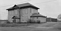
Historic Sherburne County Courthouse, built 1877
|
||
|
||

Location within the U.S. state of Minnesota
|
||
 Minnesota's location within the U.S. |
||
| Country | ||
| State | ||
| Founded | February 25, 1856 | |
| Named for | Moses Sherburne | |
| Seat | Elk River | |
| Largest city | Elk River | |
| Area | ||
| • Total | 451 sq mi (1,170 km2) | |
| • Land | 433 sq mi (1,120 km2) | |
| • Water | 18 sq mi (50 km2) 4.0%% | |
| Population
(2020)
|
||
| • Total | 97,183 | |
| • Estimate
(2023)
|
102,206 |
|
| • Density | 225/sq mi (87/km2) | |
| Time zone | UTC−6 (Central) | |
| • Summer (DST) | UTC−5 (CDT) | |
| Congressional district | 6th | |
Sherburne County is a county located in Central Minnesota. A county is like a smaller region within a state, often with its own local government. In 2020, about 97,183 people lived here. The main town, or county seat, where the county government is located, is Elk River.
Recently, in late 2024, Baldwin Township became a city called the City of Baldwin. This change helps the area get more money from the state and federal governments. Sherburne County is also part of the larger Minneapolis-St. Paul-Bloomington area, which is a big group of cities and towns.
Contents
History of Sherburne County
To understand Sherburne County, let's look back in time. The area was first part of the Wisconsin Territory starting in 1836. Later, in 1849, the Minnesota Territory was created.
How Sherburne County Was Formed
In 1856, a part of Benton County was separated to create a new county. This new county was named Sherburne. It was named after Moses Sherburne, an important lawyer and judge from that time. He was a judge for the Minnesota Territory's highest court.
Early Settlements and County Seat Changes
The area that is now Big Lake Township was first settled in 1848. A small village there was called Humboldt. When Sherburne County was formed in 1856, Humboldt was chosen as the county seat.
Another area, now known as Elk River, was also settled in 1848. Two villages, Orono and Elk River Village, grew close together. By 1867, these villages had grown so much that people voted to move the county seat from Humboldt to Elk River. The two villages then joined together in 1881 and became one town called Elk River. Also in 1867, the village of Humboldt changed its name to Big Lake. The borders of Sherburne County have stayed the same since 1856.
Geography of Sherburne County
Sherburne County is a beautiful area with many natural features.
Rivers and Lakes
The mighty Mississippi River flows along the southern edge of the county. The Rum River flows through the upper eastern part. The Elk River starts in nearby Benton County and flows through the western and southern parts of Sherburne County, joining the Mississippi River at Elk River. The Saint Francis River also flows south through the middle of the county.

Land and Terrain
The land in Sherburne County has gentle, rolling hills. Some areas have trees, and there are many lakes, ponds, and low spots. The soil here has a lot of sand and gravel. This is because of glaciers that moved through the area a long, long time ago. Because of this, the soil is not as good for farming as in other parts of Minnesota. The land generally slopes down towards the south and east. The highest point in the county is about 1,110 feet above sea level. The county covers a total area of 451 square miles, with 433 square miles of land and 18 square miles of water.
Major Roads and Transportation
 U.S. Highway 10
 U.S. Highway 169
 Minnesota State Highway 24
 Minnesota State Highway 25
 Minnesota State Highway 101
 Minnesota State Highway 301
Airports in the Area
- Leaders Clear Lake Airport
- Princeton Municipal Airport
- St. Cloud Regional Airport
Neighboring Counties
- Mille Lacs County (north)
- Isanti County (northeast)
- Anoka County (east)
- Hennepin County (southeast)
- Wright County (southwest)
- Stearns County (west)
- Benton County (northwest)
Parks and Natural Areas
Sherburne County has many protected areas where nature can thrive. These places are great for enjoying the outdoors.
- Bridgeview Park Reserve
- Clear Lake Scientific and Natural Area
- Fremont Wildlife Management Area
- Grams Regional Park
- Harry W. Cater Homestead Prairie Scientific and Natural Area
- Island View Regional Park
- Oak Savanna Park
- Rice Lake Savanna Scientific and Natural Area
- Sand Dunes State Forest
- Sand Prairie Wildlife Management Area
- Sherburne National Wildlife Refuge
- Uncas Dunes Scientific and Natural Area
- William H. Houlton Conservation Area
Population and People
The number of people living in Sherburne County has grown a lot over the years.
| Historical population | |||
|---|---|---|---|
| Census | Pop. | %± | |
| 1860 | 723 | — | |
| 1870 | 2,050 | 183.5% | |
| 1880 | 3,855 | 88.0% | |
| 1890 | 5,908 | 53.3% | |
| 1900 | 7,281 | 23.2% | |
| 1910 | 8,136 | 11.7% | |
| 1920 | 9,651 | 18.6% | |
| 1930 | 9,709 | 0.6% | |
| 1940 | 10,456 | 7.7% | |
| 1950 | 10,661 | 2.0% | |
| 1960 | 12,861 | 20.6% | |
| 1970 | 18,344 | 42.6% | |
| 1980 | 29,908 | 63.0% | |
| 1990 | 41,945 | 40.2% | |
| 2000 | 64,417 | 53.6% | |
| 2010 | 88,499 | 37.4% | |
| 2020 | 97,183 | 9.8% | |
| 2023 (est.) | 102,206 | 15.5% | |
| U.S. Decennial Census 1790-1960 1900-1990 1990-2000 2010-2020 |
|||
Who Lives in Sherburne County?
The United States Census helps us understand the different groups of people living in an area. Here's a look at the population of Sherburne County in 2010 and 2020:
| Race / Ethnicity | Pop 2010 | Pop 2020 | % 2010 | % 2020 |
|---|---|---|---|---|
| White alone (NH) | 81,983 | 84,761 | 92.64% | 87.22% |
| Black or African American alone (NH) | 1,644 | 3,648 | 1.86% | 3.75% |
| Native American or Alaska Native alone (NH) | 389 | 390 | 0.43% | 0.40% |
| Asian alone (NH) | 1,126 | 1,277 | 1.27% | 1.31% |
| Pacific Islander alone (NH) | 18 | 22 | 0.02% | 0.02% |
| Some Other Race alone (NH) | 62 | 313 | 0.07% | 0.32% |
| Mixed Race/Multi-Racial (NH) | 1,336 | 3,952 | 1.51% | 4.07% |
| Hispanic or Latino (any race) | 1,941 | 2,820 | 2.19% | 2.90% |
| Total | 88,499 | 97,183 | 100.00% | 100.00% |
Note: The US Census counts Hispanic/Latino people as an ethnic group. This means they can be of any race.
Cities and Towns
Sherburne County has several cities and smaller communities.
Cities in Sherburne County
Smaller Communities (Unincorporated)
These are smaller places that are not officially cities.
Townships
Townships are local government areas, usually covering rural parts of the county.
- Becker Township
- Big Lake Township
- Blue Hill Township
- Clear Lake Township
- Haven Township
- Livonia Township
- Orrock Township
- Palmer Township
- Santiago Township
Images for kids
-
Historic Sherburne County Courthouse, built 1877
See also
 In Spanish: Condado de Sherburne para niños
