
Mille Lacs County, Minnesota facts for kids
Quick facts for kids
Mille Lacs County
|
|
|---|---|

|
|

Location within the U.S. state of Minnesota
|
|
 Minnesota's location within the U.S. |
|
| Country | |
| State | |
| Founded | May 23, 1857 |
| Named for | Mille Lacs Lake |
| Seat | Milaca |
| Largest city | Princeton |
| Area | |
| • Total | 682 sq mi (1,770 km2) |
| • Land | 572 sq mi (1,480 km2) |
| • Water | 109 sq mi (280 km2) 16%% |
| Population
(2020)
|
|
| • Total | 26,459 |
| • Estimate
(2023)
|
27,427 |
| • Density | 46.3/sq mi (17.9/km2) |
| Time zone | UTC−6 (Central) |
| • Summer (DST) | UTC−5 (CDT) |
| Congressional district | 8th |
Mille Lacs County (/məˈlæks/ MƏ-laks) is a county in the east-central part of Minnesota, a state in the United States. In 2020, about 26,459 people lived here. The main town, or county seat, is Milaca. The county was started in 1857. Its borders were made bigger in 1860.
Mille Lacs County is part of the larger Minneapolis-St. Paul area. This area is known as the Metropolitan Statistical Area. A part of the Mille Lacs Indian Reservation is also located within the county.
Contents
Understanding the Name: Mille Lacs
The name Mille Lacs comes from the French words meaning "thousand lakes." This name is linked to Mille Lacs Lake, a very large lake in the area. French explorers and traders called this region the "Region of the Thousand Lakes."
A Brief History of Mille Lacs County
The land that is now Mille Lacs County has a long history. It was first part of the Wisconsin Territory in 1836. Then, in 1849, it became part of the new Minnesota Territory.
How the County Was Formed
On May 23, 1857, Mille Lacs County was officially created. It was formed from the eastern part of Benton County. At first, it included some land that is now in Isanti County.
Changes to the County Borders
In 1858, a new county called Monroe County was formed. It included some areas that are now part of Mille Lacs County. But in 1860, Monroe County and Mille Lacs County joined together. Soon after, two townships were moved to Isanti County. This created the borders that Mille Lacs County has today.
Exploring the Geography of Mille Lacs County
Mille Lacs County has beautiful natural features. The Rum River flows south through the county. It starts from Mille Lacs Lake. Another river, the West Branch of the Rum River, joins it near Princeton.
Land and Water Features
The county has rolling hills covered with trees. There are also open areas used for farming. The land slopes down towards the south and east. The highest point is near the southwest shore of Mille Lacs Lake. This spot is about 1,371 feet (418 meters) above sea level.
The county covers about 682 square miles (1,766 square kilometers). About 572 square miles (1,481 square kilometers) is land, and 109 square miles (282 square kilometers) is water. This means about 16% of the county is water.
Major Roads and Travel
 U.S. Highway 169
 Minnesota State Highway 18
 Minnesota State Highway 23
 Minnesota State Highway 27
 Minnesota State Highway 47
 Minnesota State Highway 95
Local Airports
- Milaca Municipal Airport (18Y) is located northeast of Milaca.
- Princeton Municipal Airport (PNM) is located southwest of Princeton.
Neighboring Counties
- Aitkin County - to the north
- Kanabec County - to the northeast
- Isanti County - to the southeast
- Sherburne County - to the south
- Benton County - to the southwest
- Morrison County - to the west
- Crow Wing County - to the northwest
Parks and Protected Areas
- Father Hennepin State Park
- Four Brooks State Wildlife Management Area (part)
- Kunkel State Wildlife Management Area
- Mille Lacs Kathio State Park
- Mille Lacs National Wildlife Refuge
- Mille Lacs State Wildlife Management Area
- Rum River State Forest
- Solana State Forest (part)
Population and People of Mille Lacs County
Every ten years, the United States counts its population in a census. This helps us understand how many people live in an area.
| Historical population | |||
|---|---|---|---|
| Census | Pop. | %± | |
| 1860 | 73 | — | |
| 1870 | 1,109 | 1,419.2% | |
| 1880 | 1,501 | 35.3% | |
| 1890 | 2,845 | 89.5% | |
| 1900 | 8,066 | 183.5% | |
| 1910 | 10,705 | 32.7% | |
| 1920 | 14,180 | 32.5% | |
| 1930 | 14,076 | −0.7% | |
| 1940 | 15,558 | 10.5% | |
| 1950 | 15,165 | −2.5% | |
| 1960 | 14,560 | −4.0% | |
| 1970 | 15,703 | 7.9% | |
| 1980 | 18,430 | 17.4% | |
| 1990 | 18,670 | 1.3% | |
| 2000 | 22,330 | 19.6% | |
| 2010 | 26,097 | 16.9% | |
| 2020 | 26,459 | 1.4% | |
| 2023 (est.) | 27,421 | 5.1% | |
| U.S. Decennial Census 1790-1960 1900-1990 1990-2000 2010-2020 |
|||
In 2020, the census showed that 26,459 people lived in Mille Lacs County. Most people living in the county are White. There is also a notable population of Native American people. Other groups include Black or African American, Asian, and Hispanic or Latino people.
Towns and Villages in Mille Lacs County
Mille Lacs County has several cities and smaller communities.
Cities in the County
Special Communities
- Vineland (also known as Neyaashiing) is a census-designated place. This means it's a community that is counted in the census but isn't an official city.
Smaller Unincorporated Communities
These are small places that don't have their own local government.
- Bayview
- Cove
- Estes Brook
- Long Siding
- Opstead
- Page
- Woodward Brook
Townships in Mille Lacs County
Townships are smaller local government areas, often covering rural parts of a county.
- Bogus Brook Township
- Borgholm Township
- Bradbury Township
- Dailey Township
- East Side Township
- Greenbush Township
- Hayland Township
- Isle Harbor Township
- Kathio Township
- Lewis Township
- Milaca Township
- Milo Township
- Mudgett Township
- Onamia Township
- Page Township
- Princeton Township
- South Harbor Township
Ghost Towns
These are places that used to be towns but are now abandoned.
- Brickton
- Burnhelm Siding
- Esteville
- Freer
- Johnsdale
- Soule's Crossing
- Stirling
Images for kids
-
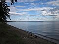
Mille Lacs Lake is located in the north of Mille Lacs County.

See also
 In Spanish: Condado de Mille Lacs para niños
