Foreston, Minnesota facts for kids
Quick facts for kids
Foreston, Minnesota
|
|
|---|---|

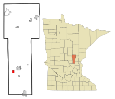
Location in Mille Lacs County and the state of Minnesota
|
|
| Country | United States |
| State | Minnesota |
| County | Mille Lacs |
| Area | |
| • Total | 1.44 sq mi (3.73 km2) |
| • Land | 1.43 sq mi (3.71 km2) |
| • Water | 0.004 sq mi (0.01 km2) |
| Elevation | 1,093 ft (333 m) |
| Population
(2020)
|
|
| • Total | 559 |
| • Density | 390.36/sq mi (150.67/km2) |
| Time zone | UTC-6 (Central (CST)) |
| • Summer (DST) | UTC-5 (CDT) |
| ZIP code |
56330
|
| Area code(s) | 320 |
| FIPS code | 27-21824 |
| GNIS feature ID | 0643815 |
Foreston is a small city in Mille Lacs County, Minnesota, in the United States. In 2020, a special count of people called a census showed that 559 people lived there.
Contents
History of Foreston
Foreston got its name because of the many forests nearby. A post office opened in the area way back in 1889. This helped the community grow and connect with other places.
Geography and Location
Foreston is located in the southwestern part of Mille Lacs County. It is about 3 miles (5 km) southwest of Milaca. Milaca is the main town and government center for the county, also known as the county seat.
The city covers a total area of about 1.44 square miles (3.73 square kilometers). Most of this area is land, with only a tiny bit (0.01 square miles or 0.02 square kilometers) being water. The West Branch of the Rum River flows through the northern part of Foreston. This river is a tributary, which means it's a smaller river that flows into a larger one, in this case, the Mississippi River.
Main Roads in Foreston
Minnesota Highway 23 is the most important road in Foreston. It connects the city to Milaca in the northeast. If you travel southwest on Highway 23, you can reach St. Cloud, which is about 26 miles (42 km) away. Other important roads include:
Population of Foreston
The number of people living in Foreston has changed over the years. Here's how the population has grown or shrunk according to the U.S. Census:
| Historical population | |||
|---|---|---|---|
| Census | Pop. | %± | |
| 1890 | 287 | — | |
| 1900 | 263 | −8.4% | |
| 1910 | 204 | −22.4% | |
| 1920 | 328 | 60.8% | |
| 1930 | 280 | −14.6% | |
| 1940 | 300 | 7.1% | |
| 1950 | 301 | 0.3% | |
| 1960 | 266 | −11.6% | |
| 1970 | 273 | 2.6% | |
| 1980 | 283 | 3.7% | |
| 1990 | 354 | 25.1% | |
| 2000 | 389 | 9.9% | |
| 2010 | 533 | 37.0% | |
| 2020 | 559 | 4.9% | |
| U.S. Decennial Census | |||
Foreston in 2010
During the census in 2010, there were 533 people living in Foreston. This means the population density was about 375 people for every square mile (145 people per square kilometer). Population density tells us how crowded an area is.
The average age of people in Foreston in 2010 was 31.3 years old.
- About 28% of the residents were under 18 years old.
- Around 8.8% were between 18 and 24 years old.
- The largest group, about 33%, was between 25 and 44 years old.
- About 22% were between 45 and 64 years old.
- And about 8% were 65 years old or older.
The population was almost evenly split between males and females, with about 52% male and 48% female.
See also
 In Spanish: Foreston (Minnesota) para niños
 | Janet Taylor Pickett |
 | Synthia Saint James |
 | Howardena Pindell |
 | Faith Ringgold |

