
Milaca, Minnesota facts for kids
Quick facts for kids
Milaca, Minnesota
|
|
|---|---|

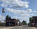
1st Street W. and Central Avenue
|
|

Location in Mille Lacs County and the state of Minnesota
|
|
| Country | United States |
| State | Minnesota |
| County | Mille Lacs |
| Area | |
| • Total | 3.55 sq mi (9.20 km2) |
| • Land | 3.35 sq mi (8.67 km2) |
| • Water | 0.20 sq mi (0.53 km2) |
| Elevation | 1,079 ft (329 m) |
| Population
(2020)
|
|
| • Total | 3,021 |
| • Density | 902.87/sq mi (348.63/km2) |
| Time zone | UTC-6 (Central (CST)) |
| • Summer (DST) | UTC-5 (CDT) |
| ZIP code |
56353
|
| Area code(s) | 320 |
| FIPS code | 27-42110 |
| GNIS feature ID | 0647836 |
Milaca (pronounced mih-LAK-uh) is a city in the state of Minnesota. It is the main town, or "county seat," of Mille Lacs County. In 2020, about 3,021 people lived there. The city is located right by the Rum River.
Contents
History of Milaca
Milaca got its start a long time ago. A post office opened here in 1883. The city's name, Milaca, comes from a shorter version of Mille Lacs Lake.
Geography and Location

Milaca is located in the southern part of Mille Lacs County. A major road, U.S. Highway 169, goes through the east side of the city. This highway can take you north about 25 miles to Mille Lacs Lake or south about 14 miles to Princeton. The big city of Minneapolis is about 64 miles south of Milaca. Another important road, Minnesota State Highway 23, also runs through Milaca. It goes northeast about 21 miles to Mora and southwest about 29 miles to St. Cloud.
The city of Milaca covers a total area of about 3.55 square miles. Most of this area, about 3.35 square miles, is land. The rest, about 0.20 square miles, is water. The Rum River flows along the west side of the city. It continues south until it joins the Mississippi River in Anoka.
Milaca's Climate and Weather
Milaca experiences a wide range of weather throughout the year. Summers are generally warm, while winters are very cold. The city gets a good amount of rain and snow.
| Climate data for Milaca, Minnesota, 1991–2020 normals, extremes 1897–present | |||||||||||||
|---|---|---|---|---|---|---|---|---|---|---|---|---|---|
| Month | Jan | Feb | Mar | Apr | May | Jun | Jul | Aug | Sep | Oct | Nov | Dec | Year |
| Record high °F (°C) | 60 (16) |
58 (14) |
81 (27) |
94 (34) |
107 (42) |
103 (39) |
108 (42) |
103 (39) |
104 (40) |
90 (32) |
74 (23) |
63 (17) |
108 (42) |
| Mean maximum °F (°C) | 40.4 (4.7) |
45.3 (7.4) |
59.7 (15.4) |
75.6 (24.2) |
86.1 (30.1) |
89.7 (32.1) |
90.5 (32.5) |
89.2 (31.8) |
85.8 (29.9) |
77.1 (25.1) |
59.0 (15.0) |
43.3 (6.3) |
93.0 (33.9) |
| Mean daily maximum °F (°C) | 20.4 (−6.4) |
26.0 (−3.3) |
38.4 (3.6) |
53.2 (11.8) |
66.4 (19.1) |
75.6 (24.2) |
80.1 (26.7) |
78.0 (25.6) |
70.4 (21.3) |
55.9 (13.3) |
39.1 (3.9) |
26.0 (−3.3) |
52.5 (11.4) |
| Daily mean °F (°C) | 10.5 (−11.9) |
14.8 (−9.6) |
27.6 (−2.4) |
41.8 (5.4) |
54.6 (12.6) |
64.7 (18.2) |
69.4 (20.8) |
66.9 (19.4) |
58.4 (14.7) |
45.0 (7.2) |
30.1 (−1.1) |
17.5 (−8.1) |
41.8 (5.4) |
| Mean daily minimum °F (°C) | 0.5 (−17.5) |
3.7 (−15.7) |
16.7 (−8.5) |
30.3 (−0.9) |
42.9 (6.1) |
53.8 (12.1) |
58.6 (14.8) |
55.8 (13.2) |
46.4 (8.0) |
34.0 (1.1) |
21.0 (−6.1) |
9.0 (−12.8) |
31.1 (−0.5) |
| Mean minimum °F (°C) | −23.8 (−31.0) |
−17.1 (−27.3) |
−6.7 (−21.5) |
17.1 (−8.3) |
30.6 (−0.8) |
40.6 (4.8) |
48.7 (9.3) |
46.2 (7.9) |
32.5 (0.3) |
21.7 (−5.7) |
3.8 (−15.7) |
−14.6 (−25.9) |
−25.6 (−32.0) |
| Record low °F (°C) | −48 (−44) |
−48 (−44) |
−32 (−36) |
−2 (−19) |
15 (−9) |
24 (−4) |
36 (2) |
32 (0) |
20 (−7) |
5 (−15) |
−22 (−30) |
−39 (−39) |
−48 (−44) |
| Average precipitation inches (mm) | 0.77 (20) |
0.85 (22) |
1.43 (36) |
2.74 (70) |
3.82 (97) |
4.31 (109) |
4.39 (112) |
3.97 (101) |
3.19 (81) |
2.82 (72) |
1.41 (36) |
1.11 (28) |
30.81 (784) |
| Average snowfall inches (cm) | 7.4 (19) |
11.1 (28) |
8.4 (21) |
4.4 (11) |
0.1 (0.25) |
0.0 (0.0) |
0.0 (0.0) |
0.0 (0.0) |
0.0 (0.0) |
0.8 (2.0) |
6.5 (17) |
10.2 (26) |
48.9 (124.25) |
| Average precipitation days (≥ 0.01 in) | 6.0 | 5.0 | 6.5 | 8.6 | 11.2 | 12.0 | 11.8 | 10.7 | 10.3 | 9.7 | 6.1 | 6.9 | 104.8 |
| Average snowy days (≥ 0.1 in) | 6.2 | 4.4 | 3.1 | 1.3 | 0.1 | 0.0 | 0.0 | 0.0 | 0.0 | 0.5 | 2.4 | 5.7 | 23.7 |
| Source 1: NOAA | |||||||||||||
| Source 2: National Weather Service | |||||||||||||
People of Milaca: Demographics

Milaca has grown steadily over the years. In 1890, only 404 people lived here. By 2020, the population had grown to 3,021.
| Historical population | |||
|---|---|---|---|
| Census | Pop. | %± | |
| 1890 | 404 | — | |
| 1900 | 1,204 | 198.0% | |
| 1910 | 1,102 | −8.5% | |
| 1920 | 1,347 | 22.2% | |
| 1930 | 1,318 | −2.2% | |
| 1940 | 1,627 | 23.4% | |
| 1950 | 1,917 | 17.8% | |
| 1960 | 1,821 | −5.0% | |
| 1970 | 1,940 | 6.5% | |
| 1980 | 2,104 | 8.5% | |
| 1990 | 2,182 | 3.7% | |
| 2000 | 2,580 | 18.2% | |
| 2010 | 2,946 | 14.2% | |
| 2020 | 3,021 | 2.5% | |
| U.S. Decennial Census | |||
Milaca's Population in 2010
In 2010, there were 2,946 people living in Milaca. These people lived in 1,308 homes. About 691 of these homes were families. The city had about 918 people per square mile.
Most of the people in Milaca were White (96.1%). There were also small numbers of African American, Native American, and Asian residents. About 0.6% of the population was Hispanic or Latino.
About 27% of homes had children under 18 living there. About 37% of homes were married couples. The average age of people in Milaca was 39.7 years old.
Education in Milaca
Milaca Public Schools include Milaca Elementary and Milaca High School. Both schools are connected and located on the west side of the city, near Highway 23 and the Rum River.
About 1,900 students attend Milaca schools from Pre-Kindergarten to 12th grade. There are around 130 teachers. The high school has a special science and research forest for learning.
Milaca High School offers 11 different varsity sports teams. They also have highly respected music and arts programs. The Star Tribune newspaper even said their music program was the best in the state! The marching band often gets high scores for their performances in the summer. The school teams are known as the Milaca Wolves.
The school district also provides special education, community education, and programs for gifted students. There is also an Area Learning Center (ALC).
Milaca Area Learning Center (ALC)
The Milaca School District has a special high school called the Milaca ALC. It is separate from the main high school. The ALC helps students who might need to retake classes. It also supports students who have other life challenges. This center offers a different way of learning that might suit them better.
The ALC has about 40 to 50 students, usually between 16 and 19 years old. Four fully licensed high school teachers work there. Students can earn credits faster at the ALC. They can get 0.5 credits per class in one quarter, compared to one semester at the main high school. Classes are longer, lasting 1.5 hours for day classes and 2 hours for after-school classes.
Some required courses can be done as independent study. This means students work on their own with guidance from a teacher. The ALC does not have its own sports or clubs. However, ALC students can join extra classes and activities at the main high school. While most ALC students live in the Milaca School District, students from other areas can also enroll. For many students, the ALC is their last chance to earn a high school diploma.
Milaca's Infrastructure and Roads
Milaca has its own airport, called the Milaca Municipal Airport.
Major Highways in Milaca
Two important highways pass through Milaca:
 U.S. Highway 169
 Minnesota State Highway 23
Images for kids
-
1st Street W. and Central Avenue
See also
 In Spanish: Milaca (Minnesota) para niños
