Kanabec County, Minnesota facts for kids
Quick facts for kids
Kanabec County
|
|
|---|---|

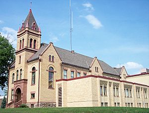
Kanabec County Courthouse in Mora (2007)
|
|

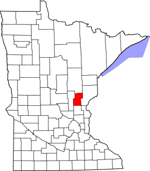
Location within the U.S. state of Minnesota
|
|
 Minnesota's location within the U.S. |
|
| Country | |
| State | |
| Founded | March 13, 1858 (created) 1882 (fully organized) |
| Named for | Snake River |
| Seat | Mora |
| Largest city | Mora |
| Area | |
| • Total | 534 sq mi (1,380 km2) |
| • Land | 522 sq mi (1,350 km2) |
| • Water | 12 sq mi (30 km2) 2.3%% |
| Population
(2020)
|
|
| • Total | 16,032 |
| • Estimate
(2023)
|
16,602 |
| • Density | 30.7/sq mi (11.9/km2) |
| Time zone | UTC−6 (Central) |
| • Summer (DST) | UTC−5 (CDT) |
| Congressional district | 8th |
Kanabec County is a county located in the east-central part of Minnesota. In 2020, about 16,032 people lived here. The main town and county seat is Mora.
The county gets its name from the Ojibwe word ginebig, which means "snake." This name comes from the Snake River, which flows through the county.
Contents
History of Kanabec County
How the County Started
Kanabec County was officially created by the Minnesota government on March 13, 1858. Its land was taken from Pine County. At first, the county didn't have a main town, and its government wasn't fully set up.
For many years, Kanabec County was managed by other nearby counties. First, it was connected to Chisago County. Later, it was connected to Pine County until 1881.
Early Settlers and Buildings
In 1870, only 53 people lived in the Kanabec County area. But in the early 1870s, many new settlers moved into the southern parts of the county. By 1876, a small, one-room wooden building was built at Millet Rapids to serve as the county office.
In 1881, Kanabec County finally became fully organized with its own government. The first county seat was set in a place called Brunswick. However, after only one court meeting there, people voted in 1882 to move the county seat to Mora. The old wooden courthouse in Mora burned down in 1894 and was replaced with a stronger, more fire-resistant building.
Geography of Kanabec County
Kanabec County has rolling hills, some covered with trees. Most of the land is used for farming. The Snake River flows through the middle of the county. Other smaller rivers and creeks, like the Groundhouse River, also flow into it. The highest point in the county is about 1,309 feet (399 meters) above sea level, located near the northwest corner.
The county covers a total area of 534 square miles. About 522 square miles is land, and 12 square miles (2.3%) is water.
Lakes in the County
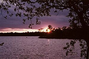
Kanabec County is home to several lakes, including:
- Ann Lake
- Bachman Dam
- Bass Lake (part)
- Beauty Lake
- Featherbed Lake
- Fish Lake
- Kent Lake
- Knife Lake
- Lake Eleven
- Lake Five
- Lake Full of Fish
- Lewis Lake
- Long Lake
- Pennington Lake
- Pomroy Lake
- Rice Lake
- Spring Lake
- Thirteen Lake
- White Lily Lake
Neighboring Counties
Kanabec County shares borders with these counties:
- Aitkin County - to the north
- Pine County - to the east
- Chisago County - to the southeast
- Isanti County - to the south
- Mille Lacs County - to the west
Protected Natural Areas
The county has several protected areas for wildlife and nature:
- Ann Lake State Wildlife Management Area
- Bean Dam State Wildlife Management Area
- Hay-Snake State Wildlife Management Area
- Rice Creek State Wildlife Management Area
- Rum River State Forest (part)
- Tosher Creek State Wildlife Management Area
- Whited State Wildlife Management Area
Historic Places to Visit
Some important historic locations in Kanabec County include:
- Ann River Logging Company Farm
- Kanabec County Courthouse
- Knife Lake prehistoric district
- Ogilvie Watertower
- C. E. Williams House
- Zetterberg Company
Transportation and Roads
Airports
- Mora Municipal Airport
Major Highways
Several state highways pass through Kanabec County:
 Minnesota State Highway 23
 Minnesota State Highway 27
 Minnesota State Highway 47
 Minnesota State Highway 65
 Minnesota State Highway 70
 Minnesota State Highway 107
County Roads
- County Road 1 - County Road 30
People of Kanabec County
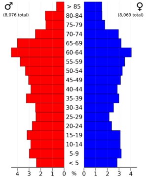
In 2020, the population of Kanabec County was 16,032 people. Most of the people living here are White (93.3%). Other groups include Black or African American (0.4%), Native American (0.7%), and Asian (0.5%). About 1.5% of the population is Hispanic or Latino.
In 2000, about 34% of households had children under 18 living with them. The average household had about 2.58 people. The median income for a household was $47,068. About 14.2% of the population lived below the poverty line.
Towns and Communities
Cities in Kanabec County
Unincorporated Communities
These are smaller communities that are not officially cities:
Townships
Kanabec County is divided into several townships:
- Ann Lake Township
- Arthur Township
- Brunswick Township
- Comfort Township
- Ford Township
- Grass Lake Township
- Hay Brook Township
- Hillman Township
- Kanabec Township
- Knife Lake Township
- Kroschel Township
- Peace Township
- Pomroy Township
- South Fork Township
- Whited Township
See also
 In Spanish: Condado de Kanabec para niños
 | May Edward Chinn |
 | Rebecca Cole |
 | Alexa Canady |
 | Dorothy Lavinia Brown |


