
Chisago County, Minnesota facts for kids
Quick facts for kids
Chisago County
|
||
|---|---|---|

Old Chisago County Courthouse originally in Center City, Minnesota, moved in 1990 to Almelund, Minnesota.
|
||
|
||

Location within the U.S. state of Minnesota
|
||
 Minnesota's location within the U.S. |
||
| Country | ||
| State | ||
| Founded | September 1, 1851 | |
| Named for | Chisago Lake | |
| Seat | Center City | |
| Largest city | North Branch | |
| Area | ||
| • Total | 442 sq mi (1,140 km2) | |
| • Land | 415 sq mi (1,070 km2) | |
| • Water | 28 sq mi (70 km2) 6.2%% | |
| Population
(2020)
|
||
| • Total | 56,621 | |
| • Estimate
(2023)
|
58,535 |
|
| • Density | 128.10/sq mi (49.46/km2) | |
| Time zone | UTC−6 (Central) | |
| • Summer (DST) | UTC−5 (CDT) | |
| Congressional district | 8th | |

Chisago County (pronounced shi-SAH-goh) is a county in the east-central part of Minnesota, a state in the United States. It covers about 442 square miles (1,145 square kilometers). In 2020, about 56,621 people lived there. Chisago County is part of the larger Minneapolis-St. Paul area.
The biggest city in the county is North Branch. The Chisago Lakes area is also found here. This area includes towns like Shafer, Chisago City, Lindström, and Center City. Center City is the county seat, which means it's where the main county government offices are. Chisago County has a mix of businesses, including factories, farms, and tourism.
Contents
History of Chisago County
Early Times
Before European settlers arrived, the land that is now Chisago County was home to Native American tribes. The Dakota lived in the southern part. The Ojibwe tribe lived in the northern part.
The first European to explore this area was Sieur duLuth in 1679. Later, in the 1700s, French and English traders set up posts. These posts were in places like Taylors Falls and Sunrise. They traded furs along the St. Croix River.
In 1837, a special agreement was made between the United States and the Ojibwe (also called Chippewa) Nation. This agreement opened up the land between the St. Croix and Mississippi Rivers for European settlers.
European Settlers Arrive
The first European settlers came to Chisago County in the early 1800s. Many of them were from Sweden. They came looking for new land and chances to start a new life. They built small farms and communities.
At first, the county's economy was based on farming, cutting down trees (logging), and mining. The forests and mines brought many people here. Many Swedes came seeking religious freedom. However, most still identified as Lutherans. Early Swedish churches, like the Chisago Lake Evangelical Lutheran Church, were often led by regular people because there weren't enough trained priests.
Chisago County officially became a county in 1851. It was part of the Minnesota Territory back then. The county got its name from Chisago Lake. The name "Chisago" comes from the Ojibwe words "Ki-chi-saga." This means "large" and "fair or lovely."
The county seat moved a few times. It started in Taylors Falls. Then it moved to Chisago City in 1865. Finally, in 1875, it moved to Center City, where it is today.
Transportation improved over time. The first bridge across the St. Croix River was built in Taylors Falls in 1856. Before that, people used ferryboats to cross. A military road was built through the county in 1868. Then, in 1870, the St. Paul and Duluth Railroad was completed. This made travel and trade much easier.
Changes in the Early 1900s
By the early 1900s, many of Chisago County's forests had been cut down. This meant sawmills closed, and lumberjacks moved away. New farm machines also meant fewer workers were needed on farms. So, the county's economy started to focus more on factories and industries. There were factories and mills that made things like flour and paper.
During this time, called the Progressive Era, there were many reform movements. Chisago County had its own way of handling education. Local school boards had a lot of control. They could choose teachers who fit in with the community.
In the 1912 presidential election, nearly 70% of Chisago County voters supported Theodore Roosevelt. He was a candidate for the Progressive Party.
Recent Times
From 1970 to 2000, Chisago County's population grew a lot, by 135%. Better roads, like Interstate Highway 35 and U.S. Highway 8, made it easier to get around. This helped businesses and industries grow.
Today, Chisago County has a mix of different businesses. It has manufacturing companies, like Anderson Corporation, which makes windows and doors. Farming is also important, with crops like corn and soybeans. Tourism is also growing. People visit the Chisago Lakes area for fun activities. The county still celebrates its strong Swedish heritage.
Geography of Chisago County
Chisago County is on Minnesota's eastern border. It is right next to Wisconsin, across the Saint Croix River. The Saint Croix River flows along the county's eastern edge. The Sunrise River flows north through the middle of the county. It joins the St. Croix River.
The county has rolling hills, which are used for farming. The land slopes down to the south and east. The highest point is about 1,017 feet (310 meters) above sea level. The county is 442 square miles (1,145 square kilometers) in total. About 415 square miles (1,075 square kilometers) is land, and 28 square miles (73 square kilometers) is water.
Main Roads
 Interstate 35
 US Highway 8
 US Highway 61
 Minnesota State Highway 95
 Minnesota State Highway 243
Neighboring Counties
- Pine County - north
- Burnett County, Wisconsin - northeast
- Polk County, Wisconsin - east
- Washington County - south
- Anoka County - southwest
- Isanti County - west
- Kanabec County - northwest
Parks and Protected Areas
- Fish Lake County Park
- Franconia Bluffs Scientific and Natural Area
- Interstate State Park
- Ojiketa Regional Park
- Saint Croix National Scenic Riverway (part)
- Wild River State Park
Climate and Weather
| Weather chart for Center City, Minnesota | |||||||||||||||||||||||||||||||||||||||||||||||
|---|---|---|---|---|---|---|---|---|---|---|---|---|---|---|---|---|---|---|---|---|---|---|---|---|---|---|---|---|---|---|---|---|---|---|---|---|---|---|---|---|---|---|---|---|---|---|---|
| J | F | M | A | M | J | J | A | S | O | N | D | ||||||||||||||||||||||||||||||||||||
|
0.9
24
2
|
0.9
31
7
|
1.6
43
19
|
2.8
59
33
|
3.7
70
45
|
4.5
79
56
|
4.4
84
60
|
3.9
81
58
|
3.6
72
49
|
2.8
60
37
|
1.9
42
22
|
1.1
27
8
|
||||||||||||||||||||||||||||||||||||
| temperatures in °F precipitation totals in inches source: The Weather Channel |
|||||||||||||||||||||||||||||||||||||||||||||||
|
Metric conversion
|
|||||||||||||||||||||||||||||||||||||||||||||||
Chisago County has a humid continental climate. This means it has long, cold winters and warm summers. In summer, the average high temperature is around 80°F (27°C). In winter, the average low temperature is around 5°F (-15°C).
The coldest temperature ever recorded was -38°F (-39°C) in January 1977. The hottest was 104°F (40°C) in July 1988.
The county gets moderate rain and snow throughout the year. It averages about 30 inches (76 cm) of rain and 47 inches (119 cm) of snow each year. Spring is when severe weather, like thunderstorms and tornadoes, is most common. Heavy snow and blizzards happen in winter.
Chisago County has many lakes and wetlands. These affect the local weather. There are over 100 lakes. The biggest ones are North and South Center Lakes, Green Lake, and Chisago Lake. These lakes help keep temperatures more steady. They absorb heat in summer and release it in winter.
People of Chisago County (Demographics)
| Historical population | |||
|---|---|---|---|
| Census | Pop. | %± | |
| 1860 | 1,743 | — | |
| 1870 | 4,358 | 150.0% | |
| 1880 | 7,982 | 83.2% | |
| 1890 | 10,359 | 29.8% | |
| 1900 | 13,248 | 27.9% | |
| 1910 | 13,537 | 2.2% | |
| 1920 | 14,445 | 6.7% | |
| 1930 | 13,189 | −8.7% | |
| 1940 | 13,124 | −0.5% | |
| 1950 | 12,669 | −3.5% | |
| 1960 | 13,419 | 5.9% | |
| 1970 | 17,492 | 30.4% | |
| 1980 | 25,717 | 47.0% | |
| 1990 | 30,521 | 18.7% | |
| 2000 | 41,101 | 34.7% | |
| 2010 | 53,887 | 31.1% | |
| 2020 | 56,621 | 5.1% | |
| 2023 (est.) | 58,535 | 8.6% | |
| U.S. Decennial Census 1790-1960 1900-1990 1990-2000 2010-2020 |
|||

In 2020, Chisago County had 56,621 people. This makes it the 18th most populated county in Minnesota. Slightly more than half (52.1%) of residents are male. The average family size is about 3 people. Most households (62.2%) are married-couple families.
Chisago County has grown very fast. From 1960 to 2010, it was one of the fastest-growing counties in Minnesota. Between 2000 and 2014, the population grew by over 12,900 people.
Most residents (95.4%) have at least a high school education. About 22.2% have a college degree or higher. About 4.9% of the people are veterans.
Ancestry and Background
Historically, most people in Chisago County have been White. Since 2000, there has been a small but growing number of Black, Asian, and Hispanic people.
The most common backgrounds in Chisago County are German, English, Swedish, Irish, and Norwegian. This shows the history of immigration to the area.
In 2021, most residents (97.9%) were born in the United States. About 78.5% were born in Minnesota. Of those born outside the U.S., more than half (56.5%) had become U.S. citizens. Most people (97.1%) speak only English at home.
In the past, most foreign-born people in the county were from Sweden. Today, the foreign-born population is more diverse. In 2022, about 1,174 people were born outside the U.S. About 40% were from Asia, 30% from Latin America, 15% from Canada, 10% from Europe, and 5% from Africa.
Religion

A study in 2020 found that many Chisago County residents are religious. The largest groups were the Catholic Church, the Evangelical Lutheran Church in America, and the Assemblies of God.
The Chisago Lake Lutheran Church is an important religious building. It was founded in 1890 and has been in Center City since 1906. It is part of the Evangelical Lutheran Church in America.
Another well-known church is the First United Methodist Church of Lindström. It has served the community for over 130 years. The Church of St. Joseph in Taylors Falls is a Catholic church. It was founded in 1854, and the current building was built in 1896.
Transportation and Economy
Most workers (80.3%) in Chisago County drive to work alone. About 9.0% carpool. A small number use public transit (1.6%), walk, or bike (2.2%). About 7.0% work from home.
The average household income in the county is $86,900. This is a bit higher than the state average. About 6.4% of residents live below the poverty line. About 2.5% are unemployed. Most homes (86.4%) are owned by the people who live in them.
Education
Chisago County has several high schools:
- Chisago Lakes High School
- North Branch Area High School
- Rush City High School
Communities
Cities
- Center City (county seat)
- Chisago City
- Harris
- Lindström
- North Branch
- Rush City
- Shafer
- Stacy
- Taylors Falls
- Wyoming
Unincorporated Communities
These are smaller communities that are not officially cities:
Townships
Townships are local government areas:
- Amador Township
- Chisago Lake Township
- Fish Lake Township
- Franconia Township
- Nessel Township
- Rushseba Township
- Shafer Township
- Sunrise Township
Culture

Chisago County's culture is greatly shaped by the German, Swedish, and Norwegian immigrants. These groups settled here in the mid-1800s.
The county was the setting for many novels by Swedish author Vilhelm Moberg. His book series, The Emigrants, tells the story of Swedish immigrants. Moberg did a lot of research to make his books accurate.
Moberg's characters, Karl-Oskar and Kristina Nilsson, settled near Lake Ki-Chi-Saga. This name comes from the Ojibwe words for "big lake with an outlet." It was later shortened to Lake Chisago.
Today, the annual Karl Oskar Days in Lindström celebrate the heritage of these early settlers.
Images for kids
-
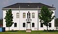
Old Chisago County Courthouse originally in Center City, Minnesota, moved in 1990 to Almelund, Minnesota.
-

Chisago County word mark.
-
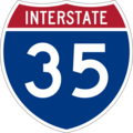
Interstate 35.
-
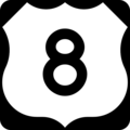
US Highway 8.
-
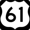
US Highway 61.
-
Minnesota State Highway 95.
-
Minnesota State Highway 243.
-
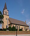
Chisago Lake Evangelical Lutheran Church.
-
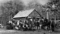
Swedish immigrants in Rush City, Minnesota, in 1887.


See also
 In Spanish: Condado de Chisago para niños
