
Polk County, Wisconsin facts for kids
Quick facts for kids
Polk County
|
|
|---|---|

|
|

Location within the U.S. state of Wisconsin
|
|
 Wisconsin's location within the U.S. |
|
| Country | |
| State | |
| Founded | 1853 |
| Named for | James K. Polk |
| Seat | Balsam Lake |
| Largest city | Amery |
| Area | |
| • Total | 956 sq mi (2,480 km2) |
| • Land | 914 sq mi (2,370 km2) |
| • Water | 42 sq mi (110 km2) 4.4%% |
| Population
(2020)
|
|
| • Total | 44,977 |
| • Estimate
(2023)
|
45,762 |
| • Density | 49.2/sq mi (19.0/km2) |
| Time zone | UTC−6 (Central) |
| • Summer (DST) | UTC−5 (CDT) |
| Congressional district | 7th |
Polk County is a county located in the state of Wisconsin in the United States. In 2020, about 44,977 people lived here. The main town, or county seat, where the county government is located, is Balsam Lake. Polk County was created in 1853 and was named after James K. Polk, who was a President of the United States.
Contents
History of Polk County
After the Wisconsin Territory was formed in 1836, a lot of land that belonged to American Indian tribes was given to the United States. This happened through a special agreement called the White Pine Treaty. Much of this land was covered in huge pine forests. Because of these many trees, people started logging (cutting down trees for wood) very soon after the treaty.
Geography of Polk County
Polk County covers a total area of about 956 square miles. Most of this area, about 914 square miles, is land. The remaining 42 square miles (which is about 4.4% of the county) is covered by water, like lakes and rivers.
Neighboring Counties
Polk County shares its borders with several other counties:
- Burnett County to the north
- Barron County to the east
- Dunn County to the southeast
- St. Croix County to the south
- Washington County, Minnesota to the southwest
- Chisago County, Minnesota to the west
Main Roads and Highways
Many important roads run through Polk County, helping people travel around. These include:
 U.S. Highway 8
 U.S. Highway 63
 Highway 35 (Wisconsin)
 Highway 46 (Wisconsin)
 Highway 48 (Wisconsin)
 Highway 65 (Wisconsin)
 Highway 87 (Wisconsin)
 Highway 243 (Wisconsin)
Railroads and Airports
Trains and planes also help connect Polk County.
- Canadian National (a railway company)
- Minnesota Transportation Museum (a museum that sometimes operates trains)
For air travel, the county has:
- Amery Municipal Airport (KAHH)
- L.O. Simenstad Municipal Airport (KOEO)
Protected Natural Areas
Part of the Saint Croix National Scenic Riverway is located in Polk County. This is a special area protected for its natural beauty and history.
Interstate Park
Interstate Park was created in 1900. It is a very important park because it is part of the Saint Croix National Scenic Riverway and the Ice Age National Scientific Reserve. It is also the westernmost point of the Ice Age National Scenic Trail, which is a long trail that shows features left behind by glaciers.
Population Information
| Historical population | |||
|---|---|---|---|
| Census | Pop. | %± | |
| 1860 | 1,400 | — | |
| 1870 | 3,422 | 144.4% | |
| 1880 | 10,018 | 192.8% | |
| 1890 | 12,968 | 29.4% | |
| 1900 | 17,801 | 37.3% | |
| 1910 | 21,367 | 20.0% | |
| 1920 | 26,870 | 25.8% | |
| 1930 | 26,567 | −1.1% | |
| 1940 | 26,197 | −1.4% | |
| 1950 | 24,944 | −4.8% | |
| 1960 | 24,968 | 0.1% | |
| 1970 | 26,666 | 6.8% | |
| 1980 | 32,351 | 21.3% | |
| 1990 | 34,773 | 7.5% | |
| 2000 | 41,319 | 18.8% | |
| 2010 | 44,205 | 7.0% | |
| 2020 | 44,977 | 1.7% | |
| U.S. Decennial Census 1790–1960 1900–1990 1990–2000 2010 2020 |
|||
2020 Census Details
In 2020, the population of Polk County was 44,977 people. This means there were about 49.2 people living in each square mile. There were also 24,129 homes in the county.
Most of the people in Polk County, about 93.5%, identified as White. Other groups included 0.9% Native American, 0.5% Asian, and 0.4% Black or African American. About 3.9% of the population identified as being from two or more races. About 2.1% of the people were Hispanic or Latino.
Education in Polk County
Polk County has several school districts that serve its communities:
- Amery School District
- Clayton School District
- Clear Lake School District
- Frederic School District
- Luck School District
- Osceola School District
- St. Croix Falls School District
- Unity School District
Communities in Polk County

Polk County is made up of different types of communities, from larger cities to smaller villages and towns.
Cities
Villages
- Balsam Lake (This is the county seat!)
- Centuria
- Clayton
- Clear Lake
- Dresser
- Frederic
- Luck
- Milltown
- Osceola
- Turtle Lake (mostly in Barron County)
Towns
- Alden
- Apple River
- Balsam Lake
- Beaver
- Black Brook
- Bone Lake
- Clam Falls
- Clayton
- Clear Lake
- Eureka
- Farmington
- Garfield
- Georgetown
- Johnstown
- Laketown
- Lincoln
- Lorain
- Luck
- McKinley
- Milltown
- Osceola
- St. Croix Falls
- Sterling
- West Sweden
Census-Designated Place
Unincorporated Communities
These are smaller communities that are not officially cities or villages.
- Atlas
- Bunyan
- Clam Falls
- Cushing
- Deronda
- East Farmington
- Eureka Center
- Fox Creek
- Horse Creek
- Indian Creek
- Joel
- Lamar
- Little Falls
- Lykens
- McKinley
- Nye
- Pole Cat Crossing (partially)
- Range
- Richardson
- Sand Lake
- Ubet
- Wanderoos
- West Denmark
- West Sweden
- Wolf Creek
Famous People from Polk County
- Arnold Franz Brasz (1888–1966) was a well-known painter, sculptor, and printmaker. He was born in Polk County.
- George A. Nelson (1873–1962) was a dairy farmer from rural Polk County. He was also a politician and ran for Vice President of the United States in 1936 for the Socialist Party of America.
Images for kids
-
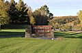
A sign for Interstate Park in Wisconsin.
-
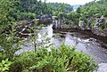
Beautiful rock formations along the St. Croix River at Interstate Park.
-
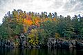
Vibrant fall colors at Interstate State Park.


.jpg)
See also
 In Spanish: Condado de Polk (Wisconsin) para niños
