St. Croix County, Wisconsin facts for kids
Quick facts for kids
Saint Croix County
|
|
|---|---|
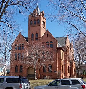
Old St. Croix County Courthouse
|
|
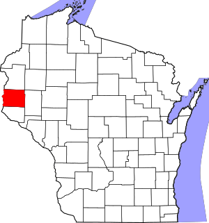
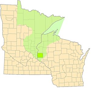
Location within the U.S. state of Wisconsin
|
|
 Wisconsin's location within the U.S. |
|
| Country | |
| State | |
| Founded | 1849 |
| Named for | St. Croix River |
| Seat | Hudson |
| Largest city | Hudson |
| Area | |
| • Total | 736 sq mi (1,910 km2) |
| • Land | 722 sq mi (1,870 km2) |
| • Water | 13 sq mi (30 km2) 1.8%% |
| Population
(2020)
|
|
| • Total | 93,536 |
| • Estimate
(2023)
|
96,763 |
| • Density | 129.5/sq mi (50.0/km2) |
| Time zone | UTC−6 (Central) |
| • Summer (DST) | UTC−5 (CDT) |
| Congressional district | 7th |
St. Croix County is a county located in the state of Wisconsin in the United States. In 2020, about 93,536 people lived here. The main city and government center is Hudson.
The county was first created in 1840, when this area was known as the Wisconsin Territory. It was officially set up in 1849. St. Croix County is part of a larger area that includes Minneapolis and St. Paul in Minnesota. Between 2000 and 2010, it was the fastest-growing county in Wisconsin, meaning many people moved here.
Contents
History of St. Croix County
St. Croix County was formed on August 3, 1840, by the government of the Wisconsin Territory. It got its name from the river that forms its western border.
There are different stories about how the river got its name. One idea is that it was named after Monsieur St. Croix, an explorer who sadly drowned in the river in the late 1600s. Another story says that Father Hennepin gave the region the French name Ste Croix (Holy Cross). He might have done this because of burial markers he saw at the river's mouth.
Over time, St. Croix County became smaller as new counties were created. For example, La Pointe County was formed from its northern parts in 1845. When Wisconsin became a state in 1848, St. Croix County was divided even more. Parts of it became new counties in the Minnesota Territory, which was created in 1849.
The part of St. Croix County that stayed in Wisconsin helped form other counties. These include Pierce, Polk, Dunn, Barron, Washburn, and Burnett Counties.
The New Richmond Tornado of 1899
On June 12, 1899, a very powerful tornado hit New Richmond. This tornado was rated as an F5, which is the strongest type. It was about 400 yards wide and traveled for 46 miles.
The tornado started near the St. Croix River, south of Hudson. It moved northeast through St. Croix County, passing through small towns like Burkhardt and Boardman. When it reached New Richmond, it destroyed the entire business area and half of the homes. The storm continued into Polk County and then Barron County.
This tornado tragically killed 117 people, mostly in New Richmond. Many more were injured. Thanks to help from the state and donations, most of New Richmond was rebuilt by the next winter. Today, this tornado is still the deadliest ever recorded in Wisconsin. It is also the 9th deadliest tornado in U.S. history.
Geography of St. Croix County
St. Croix County covers a total area of 736 square miles. Most of this (722 square miles) is land, and about 13 square miles (1.8%) is water.
Main Roads
 Interstate 94
 US Highway 12
 US Highway 63
 Wisconsin Highway 29
 Wisconsin Highway 35
 Wisconsin Highway 46
 Wisconsin Highway 64
 Wisconsin Highway 65
 Wisconsin Highway 128
 Wisconsin Highway 170
- List of county roads
Railroads
Airport
The New Richmond Regional Airport (KRNH) serves the county and nearby areas.
Protected Natural Areas
- Saint Croix National Scenic Riverway (part of it is in the county)
Neighboring Counties
- Polk County - to the north
- Barron County - to the northeast
- Dunn County - to the east
- Pierce County - to the south
- Washington County, Minnesota - to the west
Population of St. Croix County
| Historical population | |||
|---|---|---|---|
| Census | Pop. | %± | |
| 1840 | 809 | — | |
| 1850 | 624 | −22.9% | |
| 1860 | 5,392 | 764.1% | |
| 1870 | 11,035 | 104.7% | |
| 1880 | 18,956 | 71.8% | |
| 1890 | 23,139 | 22.1% | |
| 1900 | 26,830 | 16.0% | |
| 1910 | 25,910 | −3.4% | |
| 1920 | 26,106 | 0.8% | |
| 1930 | 25,455 | −2.5% | |
| 1940 | 24,842 | −2.4% | |
| 1950 | 25,905 | 4.3% | |
| 1960 | 29,164 | 12.6% | |
| 1970 | 34,354 | 17.8% | |
| 1980 | 43,262 | 25.9% | |
| 1990 | 50,251 | 16.2% | |
| 2000 | 63,155 | 25.7% | |
| 2010 | 84,345 | 33.6% | |
| 2020 | 93,536 | 10.9% | |
| U.S. Decennial Census 1790–1960 1900–1990 1990–2000 2010–2020 |
|||
2020 Census Information
According to the 2020 census, St. Croix County had 93,536 people. This means there were about 129.5 people living per square mile. There were also 37,369 homes.
Most of the people in the county (92.2%) were White. Other groups included 1.1% Asian, 0.7% Black or African American, and 0.3% Native American. About 4.5% of people were from two or more races. About 2.9% of the population was Hispanic or Latino.
Communities in St. Croix County
Cities
- Glenwood City
- Hudson (This is the county seat, where the main government offices are.)
- New Richmond
- River Falls (Most of this city is in Pierce County.)
Villages
- Baldwin
- Deer Park
- Hammond
- North Hudson
- Roberts
- Somerset
- Spring Valley (Most of this village is in Pierce County.)
- Star Prairie
- Wilson
- Woodville
Towns
Census-Designated Places
These are areas that are like towns but are not officially incorporated.
Unincorporated Communities
These are smaller communities that are not officially part of a city or village.
- Boardman
- Burkhardt
- Burkhardt Station
- Centerville
- Cylon
- Dahl
- Erin Corner
- Forest
- Glover
- Hatchville (partial)
- Hersey
- Huntington
- Jewett
- Johannesburg
- Northline
- Palmer
- Sono Junction
- Stanton
- Viking (partial)
- Wildwood
See also
 In Spanish: Condado de St. Croix para niños
 | Jackie Robinson |
 | Jack Johnson |
 | Althea Gibson |
 | Arthur Ashe |
 | Muhammad Ali |


