
St. Croix River (Wisconsin-Minnesota) facts for kids
Quick facts for kids St. Croix River |
|
| River | |
 The St. Croix River, looking downstream toward Stillwater, Minnesota
|
|
| Country | United States |
|---|---|
| States | Wisconsin, Minnesota |
| Tributaries | |
| - left | Sunrise River, Snake River, Kettle River |
| - right | Apple River, Yellow River, Namekagon River, Eau Claire River (St. Croix River), Kinnickinnic River |
| Cities | St. Croix Falls, WI, Taylors Falls, MN, Osceola, WI, Somerset, WI, Stillwater, MN, Hudson, WI, River Falls, WI, Prescott, WI |
| Source | Upper St. Croix Lake |
| - location | near Solon Springs, Wisconsin, Douglas County, WI |
| - coordinates | 46°23′19″N 91°45′34″W / 46.38861°N 91.75944°W |
| Mouth | Mississippi River |
| - location | Prescott, WI, Pierce County, Washington, Dakota, MN, WI |
| - coordinates | 44°44′45″N 92°48′10″W / 44.74583°N 92.80278°W |
| Length | 169 mi (272 km) |
The St. Croix River (which means "Holy Cross" in French) is a long river in the United States. It flows into the Mississippi River. The St. Croix River is about 169 miles (272 km) long.
This river flows through the states of Wisconsin and Minnesota. For about 125 miles (201 km), the lower part of the river forms the natural border between these two states. The river is a special place called the Saint Croix National Scenic Riverway. This means it is protected by the National Park Service because of its natural beauty. A hydroelectric power plant at St. Croix Falls, Wisconsin uses the river's water to make electricity. This power helps light up homes and businesses in the Minneapolis–St. Paul area.
Contents
How the River Got its Name
In 1683, a man named Father Louis Hennepin wrote about the river. He said it was called "The River of the Grave" because Native Americans had buried one of their men there. This person had been bitten by a rattlesnake. Father Hennepin called it Rivière du Tombeaux in French.
There are a few ideas about how the river got its current name.
- An old map from 1688 shows a "Fort St. Croix" along the upper part of the river.
- Near the river's mouth, there was a grave of a French traveler (Voyageur) marked with a cross.
- The most likely reason is that it was named after a French trader called Sainte-Croix.
The name "Rivière de Sainte-Croix" was first used for the river around 1688 or 1689. Later, on a map from 1830, it was called the "Chippewa River." But by 1843, another map helped bring back the name St. Croix.
River History
The area around the St. Croix River was once home to many American Indian tribes. The Ojibwe and Dakota were two of the main tribes. They lived by gathering wild rice, catching fish, and hunting game. Around 1745, the Dakota moved out of the St. Croix Valley after a battle.
Fur Trade Along the River
The first Europeans to visit the area were Sieur du Lhut and his team. They arrived in the fall and winter of 1679-1680. For the next 80 years, France had a lot of influence in the area. The fur trade grew a lot during this time. Beaver pelts (furs) were very important.
The Ojibwe helped with French trade in the upper part of the valley. They traded with people from Lake Superior. In the lower valley, the Dakota traded with merchants from St. Louis. After the French and Indian War ended in 1763, British traders came to the area. They became more important with the help of the powerful North West Company.
Logging and Lumber
In 1837, a special agreement called the Treaty of St. Peters was made with the Ojibwe. This agreement gave the United States government a large piece of land. This land is now in north-central Wisconsin and east-central Minnesota. This treaty opened the area for logging.
The river became very important for floating logs downstream to sawmills. Sawmills cut the logs into lumber. In the 1840s, important sawmills were in St. Croix Falls, Wisconsin and Marine on St. Croix, Minnesota. By the 1850s, Stillwater, Minnesota became the main place for lumber. Stillwater grew very quickly. New sawmills opened, and money came in, mostly from lumber companies in St. Louis.
In 1856, workers started building a special place called a boom site. This boom was two miles north of Stillwater. It was used to hold and sort the logs floating down the river. The boom worked for over 50 years. Today, the St. Croix Boom Site is a rest stop and a National Historic Landmark.
There were huge white pine forests in the upper St. Croix River valley. The wood from these forests helped build towns along Lake St. Croix. It also helped build Minneapolis and St. Paul. The St. Croix River, along with other rivers, provided wood for many cities. These included Winona, Minnesota, Davenport, Iowa, Rock Island, Illinois, and St. Louis.
The lumber business kept growing in the late 1800s. Large groups of logs floating down the river in spring could make it hard for boats to travel. Logs often got stuck in log jams where the river was narrow near St. Croix Falls. In 1883, one log jam was so big it took almost two months to clear.
At its busiest in 1890, logging in the St. Croix River valley produced a huge amount of lumber. The lumber business continued until 1912. That year, the last big log drive happened, marking the end of the rich white pine forests. It was also along the St. Croix River, in Stillwater, that the idea for the state of Minnesota was first suggested in 1848.
River Geography
The St. Croix River begins in the northwest part of Wisconsin. It flows out of Upper St. Croix Lake in Douglas County, Wisconsin. This lake is near Solon Springs, Wisconsin, about 20 miles (32 km) south of Lake Superior.
The St. Croix flows south to Gordon, then southwest. The Namekagon River joins it in northern Burnett County, Wisconsin. A few miles downstream, the St. Croix becomes the border between Minnesota and Wisconsin. It stays the border for another 130 miles (209 km) until it meets the Mississippi River.
Protecting the River
The St. Croix River was one of the first eight rivers to be protected by a law called the National Wild and Scenic Rivers Act of 1968. The upper part of the river and the Namekagon River are protected as the "St. Croix National Scenic Riverway." The only break in this protection is a hydroelectric dam at St. Croix Falls, Wisconsin. This dam is run by the Northern States Power Company.
The lower 27 miles (43 km) of the river are also protected. This includes both sides of the river along the Minnesota-Wisconsin border. This part is called the "Lower St. Croix National Scenic Riverway."
Images for kids
-
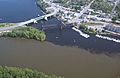
Aerial photo near Prescott, Wisconsin, where the clearer waters of the St. Croix meet the muddier Mississippi River.
-
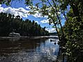
St Croix River, MN
-
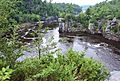
St. Croix River Dalles at Interstate State Park, Wisconsin.
-
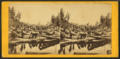
Stereoscopic photograph of logging along the St. Croix


,_1818_or_1824-after_1901.png)

See also
 In Spanish: Río St. Croix (Wisconsin-Minnesota) para niños
