
Namekagon River facts for kids
Quick facts for kids Namekagon River |
|
|---|---|

View of the Namekagon River and County E Bridge.
|
|
| Physical characteristics | |
| Length | 101 mi (163 km) |
| Part of: | Saint Croix National Scenic Riverway |

The Namekagon River (pronounced NAM-uh-KAH-gun) is a tributary of the St. Croix River. A tributary is a smaller river or stream that flows into a larger one. This river is about 101 miles (163 km) (163 km) long. You can find it in northwestern Wisconsin in the United States.
The Namekagon River is a special place. Its path is protected as part of the St. Croix National Scenic Riverway. This means it's kept safe for nature and people to enjoy. The name "Namekagon" comes from the Ojibwe language. It means "river at the place abundant with sturgeons," which are a type of large fish.
Contents
Where the River Flows
The Namekagon River starts at Lake Namakagon in southeastern Bayfield County. From there, it flows towards the southwest. It travels through Sawyer and Washburn counties. The river passes by the town of Hayward.
Then, it turns northwest and enters Burnett County. Finally, it joins the St. Croix River. This meeting point is about 45 miles (72 km) (72 km) south of the city of Superior. Near its end, another river called the Totagatic River flows into the Namekagon.
A River Through Time
The Namekagon River has a long and interesting history. For hundreds of years, it was a main travel route.
Early Uses of the River
Before roads were common, the river was like a highway. Native American tribes, fur traders, explorers, and missionaries all used the Namekagon. They traveled by canoe, moving goods and exploring new lands.
In Trego, there's a sign that tells us about a special spot. It was a natural campsite for a group of Chippewa Indians. This place was also used by many famous travelers. For example, Jonathan Carver passed through in 1767. Henry Schoolcraft also traveled here in 1831.
Native American Life (Before 1831)
The Ojibwe tribe relied on the Namekagon River for food and travel. Every May, they would use a special fish dam. This dam helped them catch sturgeon, a type of fish that lived in the river. They would guide the fish into baskets and spear them.
The river was also a key way for the Ojibwe to move around. Explorers noted that there were well-used portages. These were places where people carried their canoes and goods between different bodies of water. The Ojibwe also drew pictures on trees, called pictographs. These drawings shared information about the animals in the area. An Ojibwe village was located near Lake Pacwawong. Here, the Native Americans grew wild rice, blueberries, pumpkins, corn, potatoes, and beans.
European-American Explorers (1831-1860)
Henry Schoolcraft, an explorer who lived with Native American tribes, explored the Namekagon River twice. He described the river near Cable, Wisconsin as being about 75 feet (23 meters) wide. Its deepest part was about 18 inches (46 cm). The river banks were full of large pine, hardwood, and spruce trees.
Brook Trout were very common in the river. They were an important food source for explorers. Later, the United States government sent geologists to study the riverbed. They found that the river bottom was mostly thin sandy silt. The banks were gravelly, and there were rocks of all sizes in the middle of the river.
Logging Era (1861-1901)
Before roads were built, the Namekagon River was essential for moving timber. Loggers would cut down trees near the river. Then, they would float the logs down the river to sawmills. This was how lumber was transported during the timber boom of the 1800s.
When railways arrived, lumber companies could send wood to bigger markets. In 1855, Anthony Hayward was allowed to build and use dams along the Namekagon. These dams helped control the water for floating logs down the river.
Fun on the River

The Namekagon River is a great place for many outdoor activities. People enjoy:
- Tubing
- Kayaking
- Canoeing
- Fishing
- Hiking
- Snowshoeing
River Wildlife
The Namekagon River is home to a variety of wildlife. The most well-known fish are Brook Trout. You can also find other fish like walleye, bass, muskellunge, northern pike, and panfish.
Images for kids
-
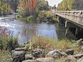
View of the Namekagon River and County E Bridge.
-
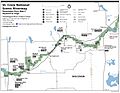
Namekagon River route from Hayward to Trego
-
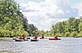
Kayaking Group near Big Bend Landing on Namekagon River
