St. Croix Boom Site facts for kids
|
St. Croix Boom Site
|
|

Former site of the St. Croix Log Boom
|
|
| Location | Off Minnesota State Highway 95, Stillwater Township, Minnesota |
|---|---|
| Area | 26.1 acres (10.6 ha) |
| Built | 1856 |
| MPS | Washington County MRA (AD) |
| NRHP reference No. | 66000407 |
Quick facts for kids Significant dates |
|
| Designated NHL | November 13, 1966 |
| Designated NRHP | November 13, 1966 |
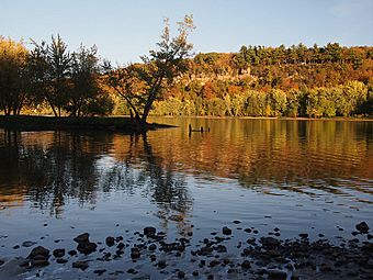
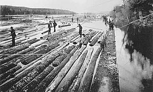
The St. Croix Boom Site is a special place along the St. Croix River in Stillwater Township, Minnesota. It's a historic park that remembers a very important time. From 1856 to 1914, this spot was a huge "log boom." This was where logs floating down the river were sorted and stored. Then, they were sent to sawmills further downstream.
This area became a park in the 1930s. In 1966, it was named a National Historic Landmark. This means it's super important to the history of industry in the United States. It was the first, most important, and longest-running place for handling logs in Minnesota's big logging industry. Today, you won't see many of the old buildings or structures.
Contents
Why the Boom Site Was Needed
The huge white pine forests in the St. Croix River Valley were a major source of timber in the mid-1800s. The St. Croix River and its smaller rivers made it easy to float logs downstream. The St. Croix River also flowed right into the Mississippi River. This was a great path to growing towns across the country.
Many logging companies sent their timber down the same river. To tell their logs apart, each company stamped a special "timber mark" on the end of their logs. In the 1830s and 40s, logs were sorted by an "honor system." But as more companies and logs came, a better system was needed.
The First Boom Company
In 1851, the Minnesota Legislature created the St. Croix Boom Company. This company had the right to collect all logs at a certain spot on the river. They would sort them by their marks and send them to the right owners. They charged 40 cents for every thousand board feet of wood.
The first boom was near Taylors Falls. But this location had two problems. First, it was above the Apple River, which was a big source of logs. Second, Stillwater was becoming the main lumber town. Mills there had to pay extra to have their logs floated 21 miles (34 km) further downstream.
Moving the Boom Site
In 1856, the Boom Company ran into money problems. A group of lumbermen from Stillwater, led by Isaac Staples, bought the company. Staples knew a lot about log booms from his home state of Maine. He chose a perfect new spot for the boom. It was 3 miles (4.8 km) north of Stillwater. This part of the river was narrow and had high banks. It also had small islands that naturally divided the river into different channels.
How the Log Boom Worked
The St. Croix Log Boom used many "booms." These were logs chained together across the river. They caught the timber as it floated downstream. Workers called "boom rats" walked on special paths among the booms. They checked the timber marks on the logs. Then, they sorted the logs into different holding areas.
When enough logs from one company were gathered, the workers would tie them together into a "timber raft." A "fitting-up crew" would then steer these rafts downstream to the correct sawmill. Some logs even traveled as far south as St. Louis!
The boom could handle both a lot of logs and just a few. In summer, logs could back up for 15 miles (24 km) above the boom. Hundreds of workers would work long hours. But when things were slow, only a small crew was needed. This saved a lot of money.
In 1890, the Boom Company built the Nevers Dam 11 miles (18 km) upstream from Taylors Falls. This dam helped control the flow of logs. It also helped prevent big log jams, like the one in 1886 that caused a lot of problems.
The Boom Site's Big Impact
The huge number of logs on the river and the Boom Company's importance to the lumber industry had a big effect on the whole region.
Challenges and Complaints
When the river was full of logs, steamboats couldn't pass. This meant travelers couldn't move up or down the river. Farmers couldn't ship their goods to market. Towns like Taylors Falls struggled because of this. Piles of logs could also block water flow, causing floods in riverside farms and homes.
The Boom Company tried to help. They provided teams and wagons to carry people and goods around the blocked areas. Then, people could get on small steamboats upstream to continue their journeys. In the 1860s and 70s, the company even worked on a shipping canal to go around the boom site.
Sawmill owners depended on the Boom Company to get their logs. They often complained about delays and the cost of the service. When logs didn't arrive, there was less work, and money was tight in the lumber towns. The Boom Company had so much power that people called it "The Octopus."
Positive Effects
Even with the problems, the Boom Company made it possible for 150 to 200 lumber companies to work on the St. Croix River. Feeding all the lumberjacks, log drivers, and sawmill workers helped the farms all over the river valley.
The St. Croix Boom closed on June 12, 1914. By then, it had processed over 15.5 billion feet of logs! Because of the huge amount of timber, the fair sorting fee set by law, and its efficient way of managing workers, the St. Croix Boom was the most profitable in the entire Midwestern United States.
The Boom Site as a Park
The St. Croix Boom Site was one of the first places in Minnesota to get a roadside historical marker. This happened around 1929. A few years later, the Minnesota Department of Highways started making scenic parks. The Boom Site became a historic and fun "Roadside Parking Area" in the 1930s.
Building the Park
The St. Croix Boom Site Roadside Parking Area was built between 1935 and 1939. This was during the Great Depression, when many people were out of work. Federal programs, like the New Deal, helped create jobs.
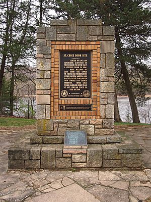
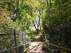
Landscape architect Arthur R. Nichols designed the park. Young men from the National Youth Administration (NYA) did most of the building. They built a permanent historical marker, a picnic area, fire rings, and toilets. They also built a stone wall, a guardrail, and stairs down to the river. They planted trees and improved a natural spring.
Changes Over Time
In 1966, the site was named a National Historic Landmark. Three years later, the Minnesota Department of Transportation (MnDOT) updated the park. They replaced the old restrooms, walls, and fences. They also redesigned the parking area and added paved paths, picnic tables, drinking fountains, and new stair railings.
Over the years, other parts built by the NYA were removed. These included the spring enclosure, another guard rail, and some fireplaces. Even though many New Deal-era parks are on the National Register of Historic Places, the Boom Site was not. This is because too many of its original features had been changed.
Reopening the Park
In 2008, during a tough economic time, MnDOT closed 86 parks. They said these parks were no longer needed for transportation safety. But two groups, the Friends of Washington County and the Friends of the St. Croix Boom Site, worked hard to reopen it.
In 2010, MnDOT gave control of the park to the Minnesota Department of Natural Resources. In 2014, the two Friends groups helped gather ideas for new improvements. People suggested things like an information kiosk, picnic shelters, and covers for the portable toilets. These new additions would look like the old logging-era buildings.
What You See Today
Today, the St. Croix Boom Site is a 26-acre (11 ha) park with five different areas. At the north end, there's a big parking and picnic area called the "wayside." A bit south, there's a smaller parking area with the historical marker and stairs down to the river.
About a quarter-mile (0.4 km) south, there's a scenic overlook. This spot gives you the best view of the river from your car. The overlook is next to a private marina. But a short distance downstream, there's a public boat launch.
You won't see many signs of the old log boom operation. Most of the structures were removed when the business closed in 1914. The historical marker is near where the old mess hall used to be. A small cave near the river stairs was used as a natural root cellar for food. The cook shanty was right above it. They even had a dumbwaiter (a small elevator) to send food down through a hole in the cave roof!
The scenic overlook is above the spot where the main log boom was chained across the river. Across the highway from the park is a private home. This was once the St. Croix Boom Company House and Barn, built around 1885. It was the home of the person in charge of the site. For a long time, people thought no other old buildings were left. But in 1975, a survey team found two buildings hidden by the forest. One was an office that also served as a warming hut in winter.
 | Stephanie Wilson |
 | Charles Bolden |
 | Ronald McNair |
 | Frederick D. Gregory |


