
Dunn County, Wisconsin facts for kids
Quick facts for kids
Dunn County
|
||
|---|---|---|

The Dunn County Government Center in Menomonie
|
||
|
||

Location within the U.S. state of Wisconsin
|
||
 Wisconsin's location within the U.S. |
||
| Country | ||
| State | ||
| Founded | 1857 | |
| Named for | Charles Dunn | |
| Seat | Menomonie | |
| Largest city | Menomonie | |
| Area | ||
| • Total | 864 sq mi (2,240 km2) | |
| • Land | 850 sq mi (2,200 km2) | |
| • Water | 14 sq mi (40 km2) 1.6% | |
| Population
(2020)
|
||
| • Total | 45,440 | |
| • Estimate
(2023)
|
45,794 |
|
| • Density | 53.4/sq mi (20.6/km2) | |
| Time zone | UTC−6 (Central) | |
| • Summer (DST) | UTC−5 (CDT) | |
| Congressional district | 3rd | |

Dunn County is a county located in the state of Wisconsin in the United States. A county is like a smaller area within a state, often with its own local government. In 2020, about 45,440 people lived here. The main city and where the county government is located is Menomonie. Dunn County is part of a larger area that includes Eau Claire, making it an important place for jobs and community life.
Contents
History of Dunn County
Dunn County was created in 1854 from a part of Chippewa County. It officially became an organized county in 1857. The county was named after Charles Dunn, who was the very first chief justice of the Wisconsin Territory. A chief justice is the head judge of a court system.
Geography of Dunn County
Dunn County covers a total area of about 864 square miles. Most of this area, about 850 square miles, is land. The remaining 14 square miles, which is about 1.6% of the county, is covered by water.
Counties Nearby
Dunn County shares its borders with several other counties. These are:
- Barron County to the north
- Chippewa County to the east
- Eau Claire County to the southeast
- Pepin County to the south
- Pierce County to the southwest
- Polk County to the northwest
- Saint Croix County to the west
Main Roads in Dunn County
Many important roads pass through Dunn County, helping people travel and transport goods. These include:
|
|
Transportation in Dunn County
Besides roads, Dunn County has other ways for people and goods to move around:
- Railroads: Trains run on tracks owned by Canadian National and Union Pacific.
- Buses: Dunn County Transit provides bus services for local travel.
- Airports: There are two airports in the county:
- Menomonie Municipal Airport (KLUM)
- Boyceville Municipal Airport (3T3)
People of Dunn County (Demographics)
| Historical population | |||
|---|---|---|---|
| Census | Pop. | %± | |
| 1860 | 2,704 | — | |
| 1870 | 9,488 | 250.9% | |
| 1880 | 16,817 | 77.2% | |
| 1890 | 22,664 | 34.8% | |
| 1900 | 25,043 | 10.5% | |
| 1910 | 25,260 | 0.9% | |
| 1920 | 26,970 | 6.8% | |
| 1930 | 27,037 | 0.2% | |
| 1940 | 27,375 | 1.3% | |
| 1950 | 27,341 | −0.1% | |
| 1960 | 26,156 | −4.3% | |
| 1970 | 29,154 | 11.5% | |
| 1980 | 34,314 | 17.7% | |
| 1990 | 35,909 | 4.6% | |
| 2000 | 39,858 | 11.0% | |
| 2010 | 43,857 | 10.0% | |
| 2020 | 45,440 | 3.6% | |
| U.S. Decennial Census 1790–1960 1900–1990 1990–2000 2010 2020 |
|||
2020 Census Information
In 2020, the total population of Dunn County was 45,440 people. This means there were about 53 people living in each square mile. There were also about 18,693 homes or housing units.
Most people in the county, about 90.7%, identified as White. Other groups included 3.2% Asian, 0.9% Black or African American, and 0.5% Native American. About 1.0% of people were from other races, and 3.8% identified with two or more races. About 2.3% of the population identified as Hispanic or Latino.
Communities in Dunn County
Dunn County has different types of communities, from a larger city to smaller villages and towns.
City
Villages
Towns
Census-Designated Places
These are areas identified by the U.S. Census Bureau for statistical purposes.
- Downsville
- Tainter Lake
Unincorporated Communities
These are smaller communities that are not officially part of a city or village.
Images for kids
-
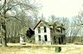
An old farmhouse in Dunn County.
-
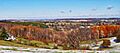
The countryside in Dunn County, west of Menomonie.


See also
 In Spanish: Condado de Dunn (Wisconsin) para niños
