
Eau Claire County, Wisconsin facts for kids
Quick facts for kids
Eau Claire County
|
|
|---|---|

Eau Claire County Courthouse, February 2015
|
|

Location within the U.S. state of Wisconsin
|
|
 Wisconsin's location within the U.S. |
|
| Country | |
| State | |
| Founded | 1856 |
| Named for | Eau Claire River |
| Seat | Eau Claire |
| Largest city | Eau Claire |
| Area | |
| • Total | 645 sq mi (1,670 km2) |
| • Land | 638 sq mi (1,650 km2) |
| • Water | 7.3 sq mi (19 km2) 1.1% |
| Population
(2020)
|
|
| • Total | 105,710 |
| • Estimate
(2023)
|
107,903 |
| • Density | 165.7/sq mi (64.0/km2) |
| Time zone | UTC−6 (Central) |
| • Summer (DST) | UTC−5 (CDT) |
| Congressional district | 3rd |

Eau Claire County is a county located in the U.S. state of Wisconsin. A county is like a large area of land with its own local government. In 2020, about 105,710 people lived here. The main city and government center, called the county seat, is Eau Claire. The county got its name from the Eau Claire River.
Eau Claire County is part of a bigger area called the Eau Claire, WI Metropolitan Statistical Area. This means it's connected to nearby cities and towns for things like jobs and services.
Contents
History of Eau Claire County
Eau Claire County has an interesting past. It was first created as the Town of Clearwater in Chippewa County in 1855.
The name was later changed to the Town of Eau Claire in March 1856. Just a few months later, in October 1856, the entire town became its own county. This happened by a special decision from the Wisconsin State Legislature.
Geography and Neighboring Areas
According to the U.S. Census Bureau, Eau Claire County covers about 645 square miles. Most of this area, about 638 square miles, is land. The rest, about 7.3 square miles, is water. This means about 1.1% of the county is covered by water.
Counties Next Door
Eau Claire County shares its borders with several other counties. These are its neighbors:
- Chippewa County to the north
- Clark County to the east
- Jackson County to the southeast
- Trempealeau County to the south
- Buffalo County to the southwest
- Pepin County to the west
- Dunn County to the west
Population Changes Over Time
The number of people living in Eau Claire County has grown a lot over the years. A census is a count of all the people in an area. Here's how the population has changed:
| Historical population | |||
|---|---|---|---|
| Census | Pop. | %± | |
| 1860 | 3,162 | — | |
| 1870 | 10,769 | 240.6% | |
| 1880 | 19,993 | 85.7% | |
| 1890 | 30,673 | 53.4% | |
| 1900 | 31,692 | 3.3% | |
| 1910 | 32,721 | 3.2% | |
| 1920 | 35,771 | 9.3% | |
| 1930 | 41,087 | 14.9% | |
| 1940 | 46,999 | 14.4% | |
| 1950 | 54,187 | 15.3% | |
| 1960 | 58,300 | 7.6% | |
| 1970 | 67,219 | 15.3% | |
| 1980 | 78,805 | 17.2% | |
| 1990 | 85,183 | 8.1% | |
| 2000 | 93,142 | 9.3% | |
| 2010 | 98,736 | 6.0% | |
| 2020 | 105,710 | 7.1% | |
| U.S. Decennial Census 1790–1960 1900–1990 1990–2000 2010 2020 |
|||
What the 2020 Census Showed
In 2020, the population of Eau Claire County was 105,710 people. This means there were about 165.7 people living in each square mile. There were also about 44,966 homes or housing units.
Most people in the county, about 88.2%, identified as White. Other groups included 4.2% Asian, 1.2% Black or African American, and 0.5% Native American. About 4.7% of people identified as being from two or more races. About 2.9% of the population was Hispanic or Latino.
Getting Around: Transportation
Eau Claire County has many ways to travel.
Main Roads
Many important highways pass through the county:
 Interstate 94
 U.S. Highway 10
 U.S. Highway 12
 U.S. Highway 53
 Highway 27 (Wisconsin)
 Highway 37 (Wisconsin)
 Highway 85 (Wisconsin)
 Highway 93 (Wisconsin)
 Highway 312 (Wisconsin)
Trains and Buses
- Railroads: The Union Pacific railroad operates in the county.
- Buses: You can use Eau Claire Transit for bus services.
Airport
The Chippewa Valley Regional Airport (KEAU) serves Eau Claire County. This is where people can fly in and out of the area.
Fun Things to Do and See
There are several interesting places to visit in Eau Claire County:
- The Chippewa Valley Museum in Eau Claire
- Dells Mill Museum in Augusta
- Dells Mill Water Powered Museum, also in Augusta
- The Paul Bunyan Logging Camp in Eau Claire
- The Sarge Boyd Bandshell in Eau Claire, which is a place for outdoor concerts.
Communities in Eau Claire County

Eau Claire County is made up of different types of communities. These include cities, villages, and towns.
Cities
- Altoona
- Augusta
- Eau Claire (This is the county seat, and a small part of it is in Chippewa County)
Villages
Towns
Census-Designated Places
These are areas that are like towns but are not officially incorporated as cities or villages:
Unincorporated Communities
These are smaller communities that are not part of an official city or village government:
Ghost Towns/Neighborhoods
These are places that used to be communities but are no longer active or populated:
- Hadleyville
- Nelsonville
- Oak Grove
- Porter's Mills
- Shawtown
Images for kids
-
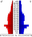
This chart shows the age groups of people in Eau Claire County from the 2000 Census.

See also
 In Spanish: Condado de Eau Claire para niños
