
Clark County, Wisconsin facts for kids
Quick facts for kids
Clark County
|
|
|---|---|

Clark County Courthouse
|
|

Location within the U.S. state of Wisconsin
|
|
 Wisconsin's location within the U.S. |
|
| Country | |
| State | |
| Founded | 1854 |
| Named for | George Rogers Clark |
| Seat | Neillsville |
| Largest city | Neillsville |
| Area | |
| • Total | 1,219 sq mi (3,160 km2) |
| • Land | 1,210 sq mi (3,100 km2) |
| • Water | 9.0 sq mi (23 km2) 0.7% |
| Population
(2020)
|
|
| • Total | 34,659 |
| • Estimate
(2023)
|
34,744 |
| • Density | 28.7/sq mi (11.1/km2) |
| Time zone | UTC−6 (Central) |
| • Summer (DST) | UTC−5 (CDT) |
| Congressional district | 7th |
Clark County is a county located in the state of Wisconsin, USA. In 2020, about 34,659 people lived there. The main town, or county seat, is Neillsville.
Contents
History of Clark County
By the early 1800s, the land that is now Clark County was used for hunting by several Native American groups. These included the Chippewa, Dakota, Ho-Chunk, and possibly Menominee peoples. In 1836, French-Canadian fur traders set up a temporary trading post there.
The first White settlers were likely Mormon loggers in 1844. They came to cut pine trees along the Black River. They floated the logs down to a sawmill and then used the wood to build a temple in Nauvoo, Illinois. This project probably ended by 1846.
In June 1845, James and Henry O'Neill arrived. They built a cabin and a sawmill. The wood they cut was sent down the river. In 1847, a big storm flooded the Black River and destroyed the mills. But the pioneers rebuilt them.

Clark County was officially created in 1853. It was named for A. W. Clark, an early settler, or for General George Rogers Clark.
Around 1900, some towns and villages started getting electricity from private power plants. But farms in the countryside had to wait longer. Electric lines were finally set up around 1937. This was done by the new Clark Electric Cooperative.
In 1920, construction began on the Clark County Asylum. This was a place for people needing long-term care. It was the last of 35 similar places built in Wisconsin. Some patients helped with the building work. They also farmed the land, growing crops like corn and potatoes. Over time, the center changed from a "custodial asylum" to a "treatment hospital." Today, it is a skilled nursing facility.
Geography of Clark County

Clark County covers a total area of about 1,219 square miles. Most of this, 1,210 square miles, is land. Only about 9 square miles (0.7%) is water.
Neighboring Counties
- Taylor County – north
- Marathon County – east
- Wood County – southeast
- Jackson County – south
- Eau Claire County – west
- Chippewa County – northwest
Main Roads
|
|
Railroads
Airport
- KVIQ – Neillsville Municipal Airport
Climate
|
||||||||||||||||||||||||||||||||||||||||||||||||||||||||||||||||||||||||||||||||||||||||||||||||
Population and Religions
| Historical population | |||
|---|---|---|---|
| Census | Pop. | %± | |
| 1860 | 789 | — | |
| 1870 | 3,450 | 337.3% | |
| 1880 | 10,715 | 210.6% | |
| 1890 | 17,708 | 65.3% | |
| 1900 | 25,848 | 46.0% | |
| 1910 | 30,074 | 16.3% | |
| 1920 | 35,120 | 16.8% | |
| 1930 | 34,165 | −2.7% | |
| 1940 | 33,972 | −0.6% | |
| 1950 | 32,459 | −4.5% | |
| 1960 | 31,527 | −2.9% | |
| 1970 | 30,361 | −3.7% | |
| 1980 | 32,910 | 8.4% | |
| 1990 | 31,647 | −3.8% | |
| 2000 | 33,557 | 6.0% | |
| 2010 | 34,690 | 3.4% | |
| 2020 | 34,659 | −0.1% | |
| 2023 (est.) | 34,774 | 0.2% | |
| U.S. Decennial Census 1790–1960 1900–1990 1990–2000 2010 2020 |
|||
2020 Census Information
In 2020, the population of Clark County was 34,659 people. There were about 28.7 people per square mile. Most of the people (92.2%) were White. Other groups included Native American, Black, and Asian people. About 6.1% of the population was Hispanic or Latino.
Religious Groups
Religion in Clark County, according to ARDA (2020) Catholic Church (22.9%) Anabaptist Churches (Amish and Mennonite) (12.5%) Evangelical Churches (11.9%) Mainline Protestant Churches (9.2%) Others (1.4%) None (42.1%)
In 2010, the largest religious groups in Clark County were:
- Catholic Church
- Missouri Synod Lutheranism
- ELCA Lutheranism
- Amish
- United Church of Christ
- Wisconsin Synod Lutheran
- United Methodist
Communities in Clark County

Cities
- Abbotsford (partly in Marathon County)
- Colby (partly in Marathon County)
- Greenwood
- Loyal
- Neillsville (county seat)
- Owen
- Thorp
- Stanley (mostly in Chippewa County)
Villages
- Curtiss
- Dorchester (partly in Marathon County)
- Granton
- Unity (mostly in Marathon County)
- Withee
Towns
Census-designated places
Unincorporated communities

Ghost towns/neighborhoods
- Kurth
- Maple Works
- Romeo
- Trow
- Worden
Education
Here are some of the school districts in Clark County:
- Abbotsford School District
- Alma Center School District
- Colby School District
- Granton Area School District
- Greenwood School District
- Loyal School District
- Marshfield School District
- Neillsville School District
- Osseo-Fairchild School District
- Owen-Withee School District
- Pittsville School District
- Spencer School District
- Stanley-Boyd Area School District
- Thorp School District
Images for kids
-
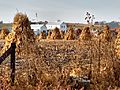
Along with modern farmers, the county has many Amish, who farm using old techniques.

See also
 In Spanish: Condado de Clark (Wisconsin) para niños
