
Neillsville, Wisconsin facts for kids
Quick facts for kids
Neillsville, Wisconsin
|
|
|---|---|

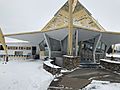
City hall
|
|

Location of Neillsville in Clark County, Wisconsin.
|
|
| Country | United States |
| State | Wisconsin |
| County | Clark |
| Area | |
| • Total | 2.85 sq mi (7.37 km2) |
| • Land | 2.75 sq mi (7.11 km2) |
| • Water | 0.10 sq mi (0.26 km2) |
| Elevation | 1,037 ft (316 m) |
| Population
(2020)
|
|
| • Total | 2,384 |
| • Density | 877.60/sq mi (338.89/km2) |
| Time zone | UTC-6 (Central (CST)) |
| • Summer (DST) | UTC-5 (CDT) |
| ZIP Code |
54456
|
| Area code(s) | 715 & 534 |
| FIPS code | 55-55800 |
| GNIS feature ID | 1570146 |
Neillsville is a city in Wisconsin, United States. It is the main city and county seat of Clark County. In 2020, about 2,384 people lived there.
Contents
History of Neillsville
The first people known to live in the Neillsville area were the Ojibwa tribe.
Early Settlers and Naming
Around 1845, James O'Neill and his group were the first European settlers to arrive. They were looking for a good spot to build a sawmill along the Black River. The city was named after James O'Neill. A nearby stream, O'Neill Creek, which flows into the Black River, also got its name from him.
Becoming the County Seat
In 1854, the area, which was first called O'Neill's Mill, was chosen as the county seat for Clark County. This means it became the main city where the county's government offices are located.
Neillsville was officially planned out on April 14, 1855. It became an incorporated city in April 1882.
Later Developments
From 1921 to 1957, a school for Winnebago Native American children was run by the Evangelical and Reformed Church on the west side of Neillsville.
A famous architect named William L. Steele lived his last years and died in Neillsville. He retired in 1946 due to poor health and moved to live with his daughter. He passed away in Neillsville on March 4, 1949.
Geography of Neillsville
Neillsville is located at 44°33′40″N 90°35′45″W / 44.56111°N 90.59583°W.
Land and Water
The city covers a total area of about 2.87 square miles (7.43 square kilometers). Most of this area, about 2.77 square miles (7.17 square kilometers), is land. The rest, about 0.10 square miles (0.26 square kilometers), is water.
Roads and Highways
Neillsville is connected by major roads. US Highway 10 and State Trunk Highway 73 both pass through the city.

Climate in Neillsville
Neillsville experiences a wide range of temperatures throughout the year. Summers are generally warm, while winters can be very cold with a lot of snow.
| Climate data for Neillsville 3ESE, Wisconsin (1991–2020 normals, extremes 1893–present) | |||||||||||||
|---|---|---|---|---|---|---|---|---|---|---|---|---|---|
| Month | Jan | Feb | Mar | Apr | May | Jun | Jul | Aug | Sep | Oct | Nov | Dec | Year |
| Record high °F (°C) | 57 (14) |
62 (17) |
83 (28) |
91 (33) |
105 (41) |
104 (40) |
106 (41) |
103 (39) |
98 (37) |
92 (33) |
81 (27) |
64 (18) |
106 (41) |
| Mean daily maximum °F (°C) | 23.5 (−4.7) |
28.7 (−1.8) |
41.0 (5.0) |
55.4 (13.0) |
67.8 (19.9) |
76.6 (24.8) |
80.4 (26.9) |
78.2 (25.7) |
70.8 (21.6) |
57.7 (14.3) |
41.9 (5.5) |
28.9 (−1.7) |
54.2 (12.3) |
| Daily mean °F (°C) | 14.4 (−9.8) |
18.4 (−7.6) |
30.4 (−0.9) |
43.6 (6.4) |
55.7 (13.2) |
65.2 (18.4) |
69.0 (20.6) |
66.9 (19.4) |
59.1 (15.1) |
46.8 (8.2) |
33.1 (0.6) |
20.8 (−6.2) |
43.6 (6.4) |
| Mean daily minimum °F (°C) | 5.4 (−14.8) |
8.2 (−13.2) |
19.8 (−6.8) |
31.9 (−0.1) |
43.7 (6.5) |
53.9 (12.2) |
57.6 (14.2) |
55.6 (13.1) |
47.3 (8.5) |
36.0 (2.2) |
24.4 (−4.2) |
12.7 (−10.7) |
33.0 (0.6) |
| Record low °F (°C) | −48 (−44) |
−46 (−43) |
−39 (−39) |
2 (−17) |
15 (−9) |
22 (−6) |
34 (1) |
31 (−1) |
14 (−10) |
4 (−16) |
−16 (−27) |
−36 (−38) |
−48 (−44) |
| Average precipitation inches (mm) | 1.11 (28) |
1.08 (27) |
1.74 (44) |
3.26 (83) |
4.45 (113) |
5.34 (136) |
3.85 (98) |
4.36 (111) |
4.01 (102) |
3.08 (78) |
1.80 (46) |
1.44 (37) |
35.52 (902) |
| Average snowfall inches (cm) | 9.1 (23) |
9.4 (24) |
7.7 (20) |
2.7 (6.9) |
0.0 (0.0) |
0.0 (0.0) |
0.0 (0.0) |
0.0 (0.0) |
0.0 (0.0) |
0.4 (1.0) |
3.4 (8.6) |
10.9 (28) |
43.6 (111) |
| Average precipitation days (≥ 0.01 in) | 7.4 | 6.3 | 7.8 | 10.6 | 12.3 | 12.5 | 10.0 | 10.4 | 10.1 | 9.3 | 6.9 | 7.9 | 111.5 |
| Average snowy days (≥ 0.1 in) | 5.8 | 5.0 | 3.3 | 1.5 | 0.0 | 0.0 | 0.0 | 0.0 | 0.0 | 0.3 | 2.0 | 5.6 | 23.5 |
| Source: NOAA | |||||||||||||
Population of Neillsville
| Historical population | |||
|---|---|---|---|
| Census | Pop. | %± | |
| 1880 | 1,050 | — | |
| 1890 | 1,936 | 84.4% | |
| 1900 | 2,104 | 8.7% | |
| 1910 | 1,957 | −7.0% | |
| 1920 | 2,160 | 10.4% | |
| 1930 | 2,118 | −1.9% | |
| 1940 | 2,562 | 21.0% | |
| 1950 | 2,663 | 3.9% | |
| 1960 | 2,728 | 2.4% | |
| 1970 | 2,750 | 0.8% | |
| 1980 | 2,780 | 1.1% | |
| 1990 | 2,680 | −3.6% | |
| 2000 | 2,731 | 1.9% | |
| 2010 | 2,463 | −9.8% | |
| 2020 | 2,384 | −3.2% | |
| U.S. Decennial Census | |||
How Many People Live Here?
In 2010, the city had 2,463 people living in 1,095 households. The population density was about 889 people per square mile. Most of the people living in Neillsville were White.
The average age of people in the city was 43.6 years old. About 21.8% of the residents were under 18 years old.
Transportation in Neillsville
Neillsville has its own airport, the Neillsville Municipal Airport (KVIQ). This airport helps people travel to and from the city.
Education in Neillsville
Neillsville has a public school system that teaches students from kindergarten all the way through 12th grade.
Schools in Neillsville
- Neillsville Elementary School
- Neillsville Middle School
- Neillsville High School (their sports teams are called the Neillsville Warriors)
There is also a private school called St. John's Lutheran School for grades K-8. It is part of the Wisconsin Evangelical Lutheran Synod. St. Mary's School, a Catholic school, used to be in Neillsville but closed in 1972.
Higher Education Opportunities
The Chippewa Valley Technical College has a center in Neillsville. Here, students can take classes to earn a GED, get an associate's degree, or take other classes for continuing education.
Fun Places to Visit in Neillsville
Neillsville has several interesting places to visit.
The High Ground Veterans Memorial
The High Ground is a special park located west of Neillsville. It is a memorial to honor military veterans. It started as a memorial for Vietnam War veterans but now includes memorials for veterans of World War I, World War II, and the Korean War.
Historic Buildings as Museums
- The old Clark County Jail, built in 1897, is now a museum where you can learn about the area's history.
- The Reed School is also a museum. Both of these buildings are listed on the National Register of Historic Places, meaning they are important historical sites.
Wisconsin Pavilion and Chatty-Belle
The Wisconsin Pavilion was a building from the 1964 New York World's Fair. After the fair, it was moved to Neillsville. Today, it is home to local radio stations WCCN and WCCN-FM, and it also has a gift shop.
On the grounds of the Wisconsin Pavilion, you can find Chatty-Belle. She is a very large cow statue and is known as the World's Largest Talking Cow!
Images for kids
-
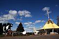
Wisconsin's 1964 World's Fair exhibit
-
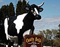
Chatty Belle, the world's largest talking cow, part of Wisconsin's contribution to the 1964 World's Fair.
-
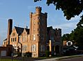
The old Clark County Jail, built in 1897, is now a historical museum.
-
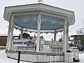
Gazebo in downtown
-
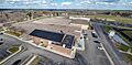
WCCN-FM and WCCN (AM) studio
-
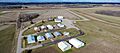
The Neillsville Municipal Airport
-
Neillsville High School


See also
 In Spanish: Neillsville (Wisconsin) para niños
