
Black River (Wisconsin) facts for kids
Quick facts for kids Black River |
|
|---|---|
.jpg)
Black River dam in Black River Falls
|
|
| Physical characteristics | |
| Main source | Central Wisconsin |
| River mouth | Mississippi River in La Crosse, Wisconsin 630 ft (190 m) |
| Length | 190 miles (310 km) |
| Basin features | |
| River system | Mississippi River |
The Black River is a cool river in west-central Wisconsin. It's a tributary of the mighty Mississippi River. This river is about 190 miles (306 km) long. A long time ago, in the 1800s, huge pine logs were floated down the Black River. They were headed for sawmills in places like La Crosse to be turned into lumber.
Contents
Where Does the Black River Flow?

The Black River starts in central Wisconsin, in a place called Taylor County. It flows generally south-southwest through several towns. These include Medford, Greenwood, Neillsville, and Black River Falls.
The Black River eventually joins the Mississippi River. It first mixes with the Mississippi in Lake Onalaska. This lake is part of the Upper Mississippi River National Wildlife and Fish Refuge. The last 10 miles (16 km) of the Black River are actually part of Lake Onalaska. This lake was formed by a dam on the Mississippi River called Lock and Dam No. 7. The Black River then leaves Lake Onalaska and fully joins the Mississippi River near La Crosse.
River Sections and Color
The Black River can be thought of in two main parts. A dam at Black River Falls divides it.
- The part of the river above the dam flows downhill quite a bit faster. Its riverbed is mostly rocky.
- The part below the dam flows much slower. This section has a sandy bottom.
The water in the Black River often has a dark, tea-like color. This color comes from natural plant materials called tannins that stain the water. This dark color is actually how the river got its name!
Smaller Rivers Joining the Black River
Several smaller rivers, called tributaries, flow into the Black River.
- The East Fork Black River starts southwest of Marshfield. It flows for about 57.5 miles (92.5 km) before joining the Black River.
- The Little Black River is another tributary. It's formed when two smaller branches, the East and West Branches, come together.
A Look Back: History of the Black River
The Black River has a long history. One of the earliest mentions of it was in 1661. A French priest reported that some Native American people, the Huron Indians, were living near the river's source.
Native American Lands and Logging
For a long time, different Native American groups lived along the Black River.
- The Ojibwe people lived along the upper part of the river.
- The Lakota lived to the west of the lower Black River.
- The Ho-Chunk people lived to the east.
In 1837, a treaty was signed that opened up northern Wisconsin for logging. At that time, the upper Black River area was full of valuable pine trees. It's thought that about 7% of all the pine forests in Wisconsin were drained by the Black River.

The Lumber Boom
The Black River became very important for the lumber industry.
- In 1839, a group of people built the first sawmill on the Black River. This was at the spot where Black River Falls is today.
- In 1841, a group of Mormons from Illinois came to the Black River. They started cutting down logs.
- In 1842, they floated a huge raft of logs all the way down the Black River and then the Mississippi River to Nauvoo, Illinois. This showed that it was possible to transport logs this way. The lumber was used to build important buildings there.
- By 1847, there were 13 sawmills on the Black River. They produced a lot of lumber!
- The sawmills on the Black River helped towns like Neillsville, Black River Falls, and La Crosse grow.
- By 1872, the Black River was helping to produce 300 million board feet of lumber every year. That's a lot of wood!
The river has also been used to transport other goods, like coal and petroleum products.
River Crossings
.jpg)
For a long time, people crossed the Black River using a ferry. This ferry started in 1861 near La Crosse. Later, a series of seven special bridges were built between 1891 and 1892. These bridges helped connect the city of La Crosse with the countryside on the other side of the river.
Images for kids
-
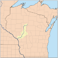
A map of the Black River watershed
-
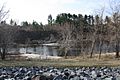
The Black River in Black River Falls


