
Great River Bluffs State Park facts for kids
Quick facts for kids Great River Bluffs State Park |
|
|---|---|

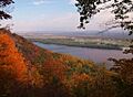
The Mississippi River from Great River Bluffs State Park
|
|

Great River Bluffs State Park
Location in Minnesota

Great River Bluffs State Park
Location in the United States
|
|
| Location | Winona, Minnesota, United States |
| Area | 3,067 acres (12.41 km2) |
| Elevation | 1,270 ft (390 m) |
| Established | 1971 |
| Governing body | Minnesota Department of Natural Resources |
Great River Bluffs State Park is a special nature area, or state park, in Minnesota, United States. It's located right next to the mighty Mississippi River, southeast of a town called Winona. This park used to be known as O. L. Kipp State Park, but its name was changed in the late 1990s. The new name, "Great River Bluffs," helps people understand what makes this park so amazing: its tall, steep cliffs, called bluffs, that rise about 500 feet (152 meters) above the river.
The park also protects the narrow valleys found between these bluffs. These areas are home to rare and delicate plant life. Two of the most important bluffs, King's and Queen's Bluff, are even more protected. They are part of the Minnesota Scientific and Natural Areas program, which helps preserve very special natural places.
Contents
How the Bluffs Were Formed: Geology of the Park
The land in this area was created over a very long time. About 500 million years ago, this region was covered by a shallow sea. Layers of sedimentary rock formed on the seafloor. The bottom layer was sandstone, and on top of that was a harder rock called dolomite.
Much later, a deep channel was carved into these rocks by the ancient Mississippi River. About 10,000 years ago, this river was much bigger and stronger. It was swollen with water from melting glaciers to the north. The softer sandstone was worn away more easily by the powerful river. This caused the harder dolomite rock above it to break off in large pieces, creating the steep rock faces you can see today.
Smaller streams flowing into the Mississippi also cut deep valleys into the river banks. This created a series of bluffs, each topped with erosion-resistant dolomite. This area is part of the Driftless Region of southeast Minnesota. This means it was not covered by the most recent ice age glaciers. Because of this, it has deep river valleys cutting through its high plains.
Creating Great River Bluffs State Park
In the 1960s, people started thinking about creating a state park along the Mississippi River bluffs. They wanted it near a highway bridge that many travelers used to enter Minnesota. In 1963, a law was passed to create a park about 1,350 acres (546 hectares) in size. The idea was for a long, narrow park along the tops of the bluffs. It would stretch between the towns of La Crescent and Dresbach. The park would be located between U.S. Route 61 at the bottom of the bluffs and a county road on top.
The state highway department was asked to suggest a name for this new roadside park. They suggested "O. L. Kipp State Park." This name honored Orin Lansing Kipp, who had worked for them for many years and helped create the Minnesota state highway system. However, when the state tried to buy the land from its private owners, the owners did not want to sell their beautiful river views. Because of this, none of the original land was ever bought for the park.
Luckily, an alternative piece of land to the north became available. This land was actually better shaped for a park and was already owned by the state! The Minnesota Department of Natural Resources' Division of Forestry had been buying land in the region since 1962. They were planning to create the Richard J. Dorer Memorial Hardwood State Forest. In 1971, a new law transferred 1,073 acres (434 hectares) from the forestry division to the parks division. This is how O. L. Kipp State Park finally came into being. It took a few more years to build the park's basic facilities. The park officially opened to the public in 1976.
Plants and Animals: Flora and Fauna

When European settlers first arrived, they cleared much of the land for farming. However, farming on these steep slopes led to a lot of soil washing away. To help stop this erosion and grow trees for timber, the state forestry division planted many trees, both native and non-native.
Later, when the land became a state park, the park's goal was to restore the natural habitat. This meant that planting non-native trees like red pine went against their new policy. As a compromise, these non-native trees are being harvested when they are fully grown. Then, more suitable native plants are put in their place.
High up on the sides of some bluffs are rare habitats called "goat prairies." Locals gave them this name because they are so steep that it looks like only goats could walk on them! These special patches of prairie grass grow only on slopes that are between 40 and 50 degrees steep and face south to southwest. This direction means they get a lot of sunlight. In winter, this sunlight causes the ground to thaw during the day and freeze again at night. This daily freezing and thawing makes it hard for woody plants like trees to grow there.
The park also has a special group of northern white cedar trees on Queen's Bluff. These trees are a "relict" stand. This means they are growing far south of where they normally would. They grew here during past ice ages and managed to survive even after the local climate became warmer.
Fun Things to Do: Recreation

Building things in the park was tricky because of the steep hills and delicate natural areas. So, the roads and trails in the park wind along the tops of the ridges. This makes them fairly flat, even though the land around them is very hilly.
The King's Bluff Nature Trail leads you out onto King's Bluff. (Just remember, the very tip of the bluff is still private property.) Other short trails take you to amazing viewpoints. Some offer stunning views of the Mississippi River and the Wisconsin shore. Others look out over the goat prairies and narrow valleys.
Queen's Bluff and some other parts of the park are off-limits to visitors, except for scientific research. This is because of the rare plants that grow there and the very dangerous, steep slopes. There is a nice picnic area where the tables are separated by trees, giving you some privacy. The park also has a campground with 31 sites and a restroom building with showers and flush toilets. There's a separate group camp that can host up to 80 tent campers. For bicyclists traveling the Great River Road, there's also a small campground with 5 sites at the bottom of the bluffs.
Images for kids
-
The Mississippi River from Great River Bluffs State Park
-
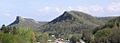
King's and Queen's Bluffs, showing their steep sides facing the Mississippi River and "goat prairies" facing the southwest
-
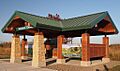
The park's unstaffed welcome center
