Winona County, Minnesota facts for kids
Quick facts for kids
Winona County
|
|
|---|---|
|
|
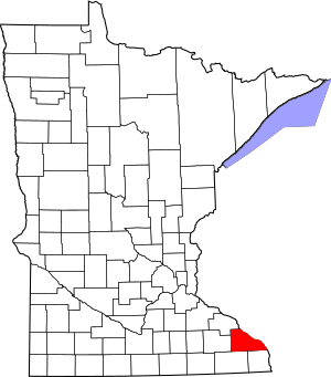
Location within the U.S. state of Minnesota
|
|
 Minnesota's location within the U.S. |
|
| Country | |
| State | |
| Founded | February 23, 1854 |
| Named for | Winona (Native American) |
| Seat | Winona |
| Largest city | Winona |
| Area | |
| • Total | 642 sq mi (1,660 km2) |
| • Land | 626 sq mi (1,620 km2) |
| • Water | 15 sq mi (40 km2) 2.4%% |
| Population
(2020)
|
|
| • Total | 49,671 |
| • Estimate
(2023)
|
49,721 |
| • Density | 79.3/sq mi (30.6/km2) |
| Time zone | UTC−6 (Central) |
| • Summer (DST) | UTC−5 (CDT) |
| Congressional district | 1st |
Winona County is a special area in the state of Minnesota, USA. It's like a big neighborhood with its own government. In 2020, about 49,671 people lived here. The main town, or county seat, is Winona. Winona County is also part of a larger area called the Winona, MN Micropolitan Statistical Area.
Contents
History of Winona County
The land where Winona County is today has a long history. First, it was part of the Wisconsin Territory starting in 1836. A "territory" is an area that isn't a state yet, but is governed by the US federal government.
Later, in 1849, the Minnesota Territory was created. The people in charge of this new territory decided to create nine counties. One of these was Wabasha County.
In 1853, a part of Wabasha County was used to create Fillmore County. Then, on February 23, 1854, a new county was made from parts of Fillmore and Wabasha counties. This new area was named Winona County.
The town of Winona became the county seat. This means it's the main town where the county government offices are. The county got its name from the town. The name "Winona" comes from a Dakota legend. It's a story about a woman named Winona who chose to jump from a rock rather than marry someone she didn't love. That rock is now called "Maiden's Rock" on Lake Pepin.
The borders of Winona County have stayed the same since 1854.
Geography of Winona County
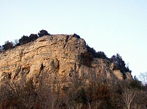
Winona County is located right on Minnesota's border with Wisconsin. It's part of a special area called the Driftless Area. This area has unique hills and valleys because glaciers didn't flatten it long ago.
The Mississippi River flows south and forms the county's eastern border. The US Army Corps of Engineers helps manage the river's locks and dams here.
Several rivers and creeks flow through the county. The Whitewater River flows north through the northwest part of the county. Other creeks like Rollingstone Creek and Garvin Brook flow east into the Mississippi.
The land in the county has low, rolling hills. The eastern part has many small valleys created by water. There are also a few lakes. Much of the land is used for farming. The highest point in the county is about 1,365 feet (416 meters) above sea level.
Winona County covers about 642 square miles (1,663 square kilometers). Most of this is land (626 sq mi or 1,621 sq km), and a small part is water (15 sq mi or 39 sq km).
Nearby Counties
Winona County shares borders with other counties in Minnesota:
- Wabasha County to the northwest
- Olmsted County to the west
- Fillmore County to the southwest
- Houston County to the south
It also borders counties in Wisconsin:
- Buffalo County, Wisconsin to the north
- Trempealeau County, Wisconsin to the northeast
- La Crosse County, Wisconsin to the east
How to Get Around
- Winona Transit Service: Local buses in Winona.
- Jefferson Lines: A bus service that connects cities.
- Amtrak (Empire Builder): A train service for longer trips.
Main Roads
- Interstate 90
- U.S. Highway 14
- U.S. Highway 61
- Minnesota State Highway 43
- Minnesota State Highway 74
- Minnesota State Highway 76
- Minnesota State Highway 248
Airports
- Winona Municipal Airport (ONA), also known as Max Conrad Field, is located northwest of Winona.
Protected Natural Areas
- Great River Bluffs State Park
- John A Latsch State Park
- Richard John Dorer Memorial Hardwood State Forest
- Upper Mississippi River National Wildlife and Fish Refuge (part)
- Whitewater State Park
- Whitewater State Wildlife Management Area (part)
- Callahan Unit
- McCarthy Ravine Unit
- South Branch Unit
- Upper South Branch Unit
Lakes in the County
- Airport Lake
- Bartlet Lake
- Bollers Lake
- Hunters Lake
- Lake Goodview
- Lake Winona
- Rileys Lake
People of Winona County (Demographics)
| Historical population | |||
|---|---|---|---|
| Census | Pop. | %± | |
| 1860 | 9,208 | — | |
| 1870 | 22,319 | 142.4% | |
| 1880 | 27,107 | 21.5% | |
| 1890 | 33,797 | 24.7% | |
| 1900 | 35,686 | 5.6% | |
| 1910 | 33,398 | −6.4% | |
| 1920 | 33,653 | 0.8% | |
| 1930 | 35,144 | 4.4% | |
| 1940 | 37,795 | 7.5% | |
| 1950 | 39,841 | 5.4% | |
| 1960 | 40,937 | 2.8% | |
| 1970 | 44,409 | 8.5% | |
| 1980 | 46,256 | 4.2% | |
| 1990 | 47,828 | 3.4% | |
| 2000 | 49,985 | 4.5% | |
| 2010 | 51,461 | 3.0% | |
| 2020 | 49,671 | −3.5% | |
| 2023 (est.) | 49,721 | −3.4% | |
| U.S. Decennial Census 1790-1960 1900-1990 1990-2000 2010-2020 |
|||
"Demographics" is about studying the people who live in an area. This includes their age, race, and how many people there are.
2020 Census Information
The 2020 census counted 49,671 people living in Winona County. Here's a look at the different groups of people:
| Race | Number of People | Percentage |
|---|---|---|
| White | 44,178 | 88.9% |
| Black or African American | 892 | 1.8% |
| Native American | 84 | 0.2% |
| Asian | 933 | 1.9% |
| Pacific Islander | 0 | 0% |
| Other/Mixed Race | 1,695 | 3.41% |
| Hispanic or Latino | 1,889 | 3.8% |
Winona Micropolitan Statistical Area
The US government has a way of grouping areas that are connected by jobs and daily life. Winona County is called the Winona, MN Micropolitan Statistical Area (μSA). A "micropolitan area" is a smaller city area with a population between 10,000 and 50,000 people. Winona is the main city in this area. In 2020, this area was ranked as the 591st largest "Core Based Statistical Area" in the United States.
Towns and Villages
Winona County has many different communities where people live.
Cities
- Altura
- Dakota
- Elba
- Goodview
- La Crescent (mostly in Houston County)
- Lewiston
- Minneiska (partly in Wabasha County)
- Minnesota City
- Rollingstone
- St. Charles
- Stockton
- Utica
- Winona (county seat)
Census-Designated Place
Unincorporated Communities
These are smaller communities that don't have their own city government.
Ghost Towns
These are places where towns once existed but are now abandoned.
Townships
Townships are smaller local government areas within a county.
- Dresbach
- Elba
- Fremont
- Hart
- Hillsdale
- Homer
- Mount Vernon
- New Hartford
- Norton
- Pleasant Hill
- Richmond
- Rollingstone
- Saint Charles
- Saratoga
- Utica
- Warren
- Whitewater
- Wilson
- Wiscoy
See also
 In Spanish: Condado de Winona para niños
 | May Edward Chinn |
 | Rebecca Cole |
 | Alexa Canady |
 | Dorothy Lavinia Brown |


