Stockton, Minnesota facts for kids
Quick facts for kids
Stockton
|
|
|---|---|

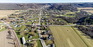
U.S. 14 goes through town
|
|

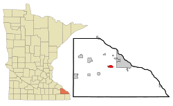
Location of Stockton, Minnesota
|
|
| Country | United States |
| State | Minnesota |
| County | Winona |
| Founded | 1856 |
| Government | |
| • Type | Mayor - Council |
| Area | |
| • Total | 1.70 sq mi (4.40 km2) |
| • Land | 1.70 sq mi (4.40 km2) |
| • Water | 0.00 sq mi (0.00 km2) |
| Elevation | 758 ft (231 m) |
| Population
(2020)
|
|
| • Total | 809 |
| • Estimate
(2021)
|
811 |
| • Density | 476.16/sq mi (183.86/km2) |
| Time zone | UTC-6 (CST) |
| • Summer (DST) | UTC-5 (CDT) |
| ZIP code |
55988
|
| Area code(s) | 507 |
| FIPS code | 27-62896 |
| GNIS feature ID | 2395971 |
Stockton is a small city located in Winona County, Minnesota, United States. It's a quiet place with a population of 809 people, according to the 2020 census.
Contents
History of Stockton
Stockton was officially planned and settled in 1856. The city was named after J. B. Stockton, who owned land there a long time ago. A post office opened in Stockton in 1855. It helped people send and receive mail until 1959.
Important Buildings and Railways
One important historical building in Stockton is the Trinity Episcopal Church. It was built in 1859. This church is so special that it's listed on the National Register of Historic Places. This means it's recognized for its important history.
The Winona and St. Peter Railroad was started in 1861 in Winona, Minnesota. By the end of 1862, the first 11 miles of track were finished. This connected Winona to Stockton. It was the second railroad ever to operate in Minnesota.
Geography of Stockton
Stockton is a city that covers about 1.70 square miles (4.40 square kilometers). All of this area is land, with no large bodies of water inside the city limits.
Population and People
| Historical population | |||
|---|---|---|---|
| Census | Pop. | %± | |
| 1880 | 214 | — | |
| 1950 | 235 | — | |
| 1960 | 242 | 3.0% | |
| 1970 | 346 | 43.0% | |
| 1980 | 517 | 49.4% | |
| 1990 | 529 | 2.3% | |
| 2000 | 682 | 28.9% | |
| 2010 | 697 | 2.2% | |
| 2020 | 809 | 16.1% | |
| 2021 (est.) | 811 | 16.4% | |
| U.S. Decennial Census 2020 Census |
|||
Population Details from 2010
In 2010, there were 697 people living in Stockton. These people lived in 260 households. A household is a group of people living together in one home. About 194 of these households were families.
The city had about 410 people per square mile. This is called the population density. There were also 282 housing units, which are places where people can live.
Most of the people in Stockton were White (95.8%). A small number were African American (0.7%) or Asian (2.4%). About 1.7% of the population was Hispanic or Latino.
Households and Age Groups
Out of the 260 households:
- 34.2% had children under 18 living with them.
- 60.8% were married couples living together.
- 7.3% had a female head of the household with no husband present.
- 6.5% had a male head of the household with no wife present.
- 25.4% were not families, meaning individuals or unrelated people living together.
The average household had 2.68 people. The average family had 3.02 people.
The average age of people in Stockton was 35.9 years old.
- 25.4% of residents were under 18.
- 7.8% were between 18 and 24.
- 27.3% were between 25 and 44.
- 30.6% were between 45 and 64.
- 9% were 65 years old or older.
There were slightly more males (51.2%) than females (48.8%) in the city.
Notable People from Stockton
- Dr. Helen Putnam
See also
 In Spanish: Stockton (Minnesota) para niños
 | DeHart Hubbard |
 | Wilma Rudolph |
 | Jesse Owens |
 | Jackie Joyner-Kersee |
 | Major Taylor |


