Witoka, Minnesota facts for kids
Quick facts for kids
Witoka
|
|
|---|---|

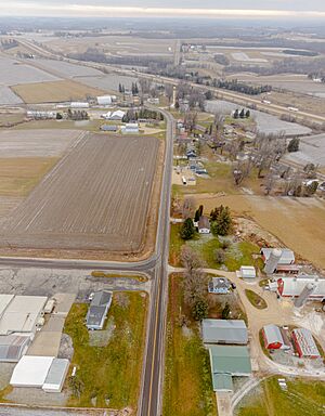
County Road 12 goes through town and County Road 17 goes under I-90
|
|
| Country | United States |
| State | Minnesota |
| County | Winona County |
| Township | Wilson Township and Wiscoy Township |
| Elevation | 1,335 ft (407 m) |
| Time zone | UTC-6 (Central (CST)) |
| • Summer (DST) | UTC-5 (CDT) |
| ZIP code |
55987
|
| Area code(s) | 507 |
| GNIS feature ID | 654296 |
Witoka is a small, unincorporated community located in Winona County, Minnesota, United States. An unincorporated community is a place that doesn't have its own local government. Instead, it's part of a larger county or township.
Contents
Exploring Witoka's Location
Witoka is found in southeastern Minnesota. It sits near where several county roads meet. These roads include County Roads 9, 12, 15, and 17.
Major Roads Nearby
You can find Interstate 90 and State Highway 76 close to Witoka. These are important roads for travel.
Townships and Neighbors
Witoka is located across two different townships. These are Wilson Township and Wiscoy Township. Nearby towns include Winona, Wilson, Centerville, and Ridgeway.
Local Waterways
Several creeks flow near Witoka. These include Cedar Creek, Money Creek, and Pleasant Valley Creek. They add to the natural beauty of the area.
Witoka's Past: A Brief History
Witoka has a history that dates back to the mid-1800s. It was officially planned and mapped out in 1855. This process is called "platting."
How Witoka Got Its Name
The community was named after the daughter of an Indian chief. This gives Witoka a unique and meaningful name.
The Old Post Office
A post office was opened in Witoka in 1857. This was an important place for people to send and receive mail. The post office served the community for many years. It finally closed its doors in 1918.
 | Selma Burke |
 | Pauline Powell Burns |
 | Frederick J. Brown |
 | Robert Blackburn |


