Wabasha County, Minnesota facts for kids
Quick facts for kids
Wabasha County
|
|
|---|---|
|
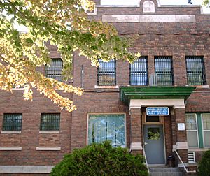
Wabasha County Courthouse
|
|

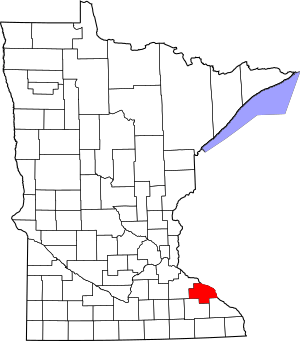
Location within the U.S. state of Minnesota
|
|
 Minnesota's location within the U.S. |
|
| Country | |
| State | |
| Founded | October 27, 1849 |
| Named for | Wabasha (city) |
| Seat | Wabasha |
| Largest city | Lake City |
| Area | |
| • Total | 550 sq mi (1,400 km2) |
| • Land | 523 sq mi (1,350 km2) |
| • Water | 27 sq mi (70 km2) 4.8%% |
| Population
(2020)
|
|
| • Total | 21,387 |
| • Estimate
(2023)
|
21,683 |
| • Density | 40.9/sq mi (15.8/km2) |
| Time zone | UTC−6 (Central) |
| • Summer (DST) | UTC−5 (CDT) |
| Congressional district | 2nd |
Wabasha County is a county located in the state of Minnesota in the United States. In 2020, about 21,387 people lived there. The main city and government center, called the county seat, is Wabasha. Wabasha County is also part of the larger Rochester area.
Contents
History of Wabasha County
Wabasha County was created on October 27, 1849. This happened when the government of the Minnesota Territory was just starting. It was one of the first nine counties in the territory.
A small area on the west side of the Mississippi River was growing. It was first called Cratte's Landing. This area became a town, then a city, named Wabasha. When the county was formed, Wabasha city was chosen as its main government center. The city was named after three important leaders of the Dakota Native American people.
Over time, the size of Wabasha County changed. In 1853, parts of it were used to create Fillmore, Goodhue, and Rice counties. More land was taken in 1854 to form Winona County. In 1855, another part became Olmsted County. The county's borders have stayed the same since 1855.
Geography and Nature
Wabasha County is located on Minnesota's border with Wisconsin. The Mississippi River flows along the county's eastern edge. Several rivers and creeks flow through the county. These include the Whitewater River and the Zumbro River, which both flow into the Mississippi.
The land in the county has low, rolling hills. These hills have many small valleys created by water. Most of the land is used for farming. The highest point in the county is about 1,191 feet (363 meters) above sea level. Wabasha County covers about 550 square miles. About 523 square miles are land, and 27 square miles (4.8%) are water.
Main Roads in Wabasha County
Neighboring Counties
- Pepin County, Wisconsin - northeast
- Buffalo County, Wisconsin - east
- Winona County - southeast
- Olmsted County - south
- Goodhue County - west, northwest
Protected Natural Areas
- Carley State Park
- Kellogg-Weaver Dunes Scientific and Natural Area
- Mazeppa State Wildlife Management Area
- McCarthy Lake State Wildlife Management Area
- Miller Creek Aquatic Management Area
- Zumbro Falls Woods Scientific and Natural Area
Lakes in Wabasha County
- Lake Pepin (part)
- Robinson Lake
- Zumbro Lake (part)
- These lakes are located within the Upper Mississippi River National Wildlife and Fish Refuge:
- Cross Lake
- Half Moon Lake
- Maloney Lake
- McCarthy Lake
- Peterson Lake
- Robinson Lake
Population and People
| Historical population | |||
|---|---|---|---|
| Census | Pop. | %± | |
| 1850 | 243 | — | |
| 1860 | 7,228 | 2,874.5% | |
| 1870 | 15,850 | 119.3% | |
| 1880 | 18,206 | 14.9% | |
| 1890 | 16,972 | −6.8% | |
| 1900 | 18,924 | 11.5% | |
| 1910 | 18,554 | −2.0% | |
| 1920 | 17,919 | −3.4% | |
| 1930 | 19,613 | 9.5% | |
| 1940 | 17,653 | −10.0% | |
| 1950 | 16,878 | −4.4% | |
| 1960 | 17,007 | 0.8% | |
| 1970 | 17,224 | 1.3% | |
| 1980 | 19,335 | 12.3% | |
| 1990 | 19,744 | 2.1% | |
| 2000 | 21,610 | 9.5% | |
| 2010 | 21,676 | 0.3% | |
| 2020 | 21,387 | −1.3% | |
| 2023 (est.) | 21,683 | 0.0% | |
| U.S. Decennial Census 1790-1960 1900-1990 1990-2000 2010-2020 |
|||
The population of Wabasha County has changed over many years. The U.S. Census counts how many people live in an area every ten years. You can see how the population has grown and changed in the table above.
Population in 2020
| Group | Number of People | Percentage |
|---|---|---|
| White | 19,921 | 93.2% |
| Black or African American | 121 | 0.6% |
| Native American | 32 | 0.2% |
| Asian | 97 | 0.5% |
| Pacific Islander | 6 | 0.03% |
| Other or Mixed Race | 502 | 2.35% |
| Hispanic or Latino | 708 | 3.31% |
In 2020, most people living in Wabasha County were White. There were also smaller groups of people from other backgrounds. About 3.31% of the population was of Hispanic or Latino origin.
Cities and Towns
Cities in Wabasha County
- Bellechester (partly in Goodhue County)
- Elgin
- Hammond
- Kellogg
- Lake City (partly in Goodhue County)
- Mazeppa
- Millville
- Minneiska (partly in Winona County)
- Plainview
- Wabasha (county seat)
- Zumbro Falls
Smaller Communities (Unincorporated)
These are places that are not officially cities or towns.
Townships
Townships are smaller local government areas within a county.
- Chester
- Elgin
- Gillford
- Glasgow
- Greenfield
- Highland
- Hyde Park
- Lake
- Mazeppa
- Minneiska
- Mount Pleasant
- Oakwood
- Pepin
- Plainview
- Watopa
- West Albany
- Zumbro
See also
 In Spanish: Condado de Wabasha para niños
 | Stephanie Wilson |
 | Charles Bolden |
 | Ronald McNair |
 | Frederick D. Gregory |


