Hammond, Minnesota facts for kids
Quick facts for kids
Hammond
|
|
|---|---|

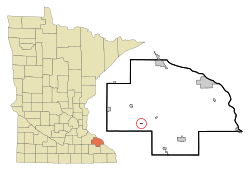
Location of Hammond, Minnesota
|
|
| Country | United States |
| State | Minnesota |
| County | Wabasha |
| Area | |
| • Total | 0.18 sq mi (0.46 km2) |
| • Land | 0.16 sq mi (0.42 km2) |
| • Water | 0.02 sq mi (0.05 km2) |
| Elevation | 807 ft (246 m) |
| Population
(2020)
|
|
| • Total | 130 |
| • Density | 812.50/sq mi (313.16/km2) |
| Time zone | UTC-6 (Central (CST)) |
| • Summer (DST) | UTC-5 (CDT) |
| ZIP code |
55991
|
| Area code(s) | 507 |
| FIPS code | 27-26828 |
| GNIS feature ID | 0644609 |
Hammond is a small city located in Wabasha County, Minnesota, in the United States. In 2010, the city had a population of 132 people. By 2020, the population was 130.
Contents
Hammond's Story: A Look Back
The city of Hammond got its name from a person named Joseph Hammond. He was the first owner of the land where the city was built.
In September 2010, something big happened in Hammond. The nearby Zumbro River flooded, and the city had to be evacuated. This means everyone had to leave their homes for safety. About two-thirds of the houses in Hammond were badly damaged by the floodwaters.
Where is Hammond? (Geography)
Hammond is a small place in terms of its size. According to the United States Census Bureau, the city covers a total area of about 0.12 square miles (0.31 square kilometers). Most of this area, about 0.11 square miles (0.28 square kilometers), is land. A small part, about 0.01 square miles (0.03 square kilometers), is water.
The main roads that help people get around Hammond are Wabasha County Roads 6 and 11.
Who Lives in Hammond? (Population)
The population of Hammond has changed over the years. Here's how many people have lived in the city during different census counts:
| Historical population | |||
|---|---|---|---|
| Census | Pop. | %± | |
| 1900 | 238 | — | |
| 1910 | 241 | 1.3% | |
| 1920 | 226 | −6.2% | |
| 1930 | 184 | −18.6% | |
| 1940 | 252 | 37.0% | |
| 1950 | 192 | −23.8% | |
| 1960 | 205 | 6.8% | |
| 1970 | 179 | −12.7% | |
| 1980 | 178 | −0.6% | |
| 1990 | 205 | 15.2% | |
| 2000 | 198 | −3.4% | |
| 2010 | 132 | −33.3% | |
| 2020 | 130 | −1.5% | |
| U.S. Decennial Census | |||
People of Hammond: A Closer Look
In 2010, a census was taken to count the people in Hammond. Here are some interesting facts from that time:
- There were 132 people living in the city.
- These people lived in 59 different homes, and 34 of those homes were families.
- The population density was about 1,200 people for every square mile (463 people per square kilometer) of land.
- There were 65 housing units (places where people could live).
Most of the people in Hammond were White, making up 97.0% of the population. About 3.0% of the people were from other races. Also, 5.3% of the population identified as Hispanic or Latino.
Let's look at the homes:
- About 18.6% of the homes had children under 18 living there.
- 37.3% of the homes were married couples living together.
- 10.2% of homes had a female head of the house with no husband present.
- Another 10.2% had a male head of the house with no wife present.
- 42.4% of the homes were not families (meaning individuals or unrelated people living together).
- About 32.2% of all homes were made up of just one person.
- 6.8% of homes had someone living alone who was 65 years old or older.
- On average, there were 2.24 people in each home.
- For families, the average size was 2.74 people.
The average age of people in Hammond in 2010 was 45.7 years old.
- 12.9% of residents were under 18 years old.
- 8.3% were between 18 and 24 years old.
- 27.3% were between 25 and 44 years old.
- 43.2% were between 45 and 64 years old.
- 8.3% were 65 years old or older.
When it came to gender, 53.8% of the population was male, and 46.2% was female.
See also
 In Spanish: Hammond (Minnesota) para niños
 | May Edward Chinn |
 | Rebecca Cole |
 | Alexa Canady |
 | Dorothy Lavinia Brown |

