Zumbro Falls, Minnesota facts for kids
Quick facts for kids
Zumbro Falls
|
|
|---|---|

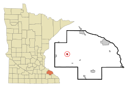
Location of Zumbro Falls, Minnesota
|
|
| Country | United States |
| State | Minnesota |
| County | Wabasha |
| Area | |
| • Total | 0.62 sq mi (1.60 km2) |
| • Land | 0.58 sq mi (1.51 km2) |
| • Water | 0.03 sq mi (0.08 km2) |
| Elevation | 843 ft (257 m) |
| Population
(2020)
|
|
| • Total | 155 |
| • Density | 264.96/sq mi (102.34/km2) |
| Time zone | UTC-6 (Central (CST)) |
| • Summer (DST) | UTC-5 (CDT) |
| ZIP code |
55991
|
| Area code(s) | 507 |
| FIPS code | 27-72310 |
| GNIS feature ID | 0654507 |
Zumbro Falls is a small city in Wabasha County, Minnesota, United States. It is located along the Zumbro River. In 2020, about 155 people lived there. Major roads like U.S. Highway 63 and Minnesota 60 meet in Zumbro Falls.
Contents
History of Zumbro Falls
The first settlement in the area began in 1857. It was on the south side of the Zumbro River. In 1866, a grist-mill dam was built. This dam created the "falls" that gave the town its name. Over time, many floods have washed away most of the dam.
Relocation and Growth
Because of frequent floods and even a tornado, the town moved. It was rebuilt on the north side of the river. A railroad line reached the new settlement in 1881. The city officially became a city in 1898.
Recent Challenges
In September 2010, Zumbro Falls faced another big flood. The entire city had to be evacuated. Many buildings were either destroyed or badly damaged by the water.
Historic Places in Zumbro Falls
The city has two important places listed on the National Register of Historic Places. These are special places recognized for their history. They include the Zumbro Parkway Bridge, built in 1937, and Bridge 5827, built in 1938.
Geography of Zumbro Falls
Zumbro Falls covers a total area of about 0.61 square miles (1.60 square kilometers). Most of this area is land, about 0.58 square miles (1.51 square kilometers). A small part, about 0.03 square miles (0.08 square kilometers), is water.
The main roads that go through the community are U.S. Highway 63 and Minnesota Highway 60.
Population of Zumbro Falls
| Historical population | |||
|---|---|---|---|
| Census | Pop. | %± | |
| 1900 | 173 | — | |
| 1910 | 208 | 20.2% | |
| 1920 | 193 | −7.2% | |
| 1930 | 186 | −3.6% | |
| 1940 | 212 | 14.0% | |
| 1950 | 172 | −18.9% | |
| 1960 | 164 | −4.7% | |
| 1970 | 203 | 23.8% | |
| 1980 | 208 | 2.5% | |
| 1990 | 237 | 13.9% | |
| 2000 | 177 | −25.3% | |
| 2010 | 207 | 16.9% | |
| 2020 | 155 | −25.1% | |
| U.S. Decennial Census | |||
The population of Zumbro Falls has changed over the years. In 1900, there were 173 people. The population reached its highest point in 1990 with 237 residents. By 2020, the population was 155 people.
Who Lives in Zumbro Falls?
According to the census from 2010, there were 207 people living in Zumbro Falls. These people lived in 84 households, and 54 of these were families. The city had about 357 people per square mile.
Most of the people in Zumbro Falls were White (93.7%). A small number were African American (1.0%) or from two or more races (5.3%). About 0.5% of the population was Hispanic or Latino.
Many households (32.1%) had children under 18 living with them. About 48.8% of households were married couples. The average age in the city was 35.2 years old.
See also
 In Spanish: Zumbro Falls (Minnesota) para niños
 | Dorothy Vaughan |
 | Charles Henry Turner |
 | Hildrus Poindexter |
 | Henry Cecil McBay |

