
Pepin County, Wisconsin facts for kids
Quick facts for kids
Pepin County
|
|
|---|---|

Pepin County Building
|
|

Location within the U.S. state of Wisconsin
|
|
 Wisconsin's location within the U.S. |
|
| Country | |
| State | |
| Founded | February 25, 1858 |
| Named for | Lake Pepin |
| Seat | Durand |
| Largest city | Durand |
| Area | |
| • Total | 249 sq mi (640 km2) |
| • Land | 232 sq mi (600 km2) |
| • Water | 17 sq mi (40 km2) 6.7%% |
| Population
(2020)
|
|
| • Total | 7,318 |
| • Estimate
(2023)
|
7,441 |
| • Density | 31.5/sq mi (12.2/km2) |
| Time zone | UTC−6 (Central) |
| • Summer (DST) | UTC−5 (CDT) |
| Congressional district | 3rd |
Pepin County is a county located in the state of Wisconsin, United States. It is known for its beautiful natural areas. In 2020, about 7,318 people lived here. This makes it one of the smallest counties in Wisconsin by population. It is also the smallest county in Wisconsin by land area. The main city and county seat is Durand.
Pepin County is famous for being the birthplace of Laura Ingalls Wilder. She wrote the popular Little House on the Prairie children's books.
Contents
History of Pepin County

Pepin County was created in 1858. It was formed from parts of Dunn County. The name "Pepin" comes from Lake Pepin. This lake is a wide part of the Mississippi River. It sits between Pepin County and counties in Minnesota.
The lake was likely named after a French Canadian family. They were from Trois-Rivières in Quebec, Canada. People like Guillaume Pepin and his family were early explorers. They may have traveled with Daniel Greysolon, Sieur du Lhut, in 1679.
The name "Pepin" for the lake has been used since at least 1700. This makes it one of the oldest place names in Wisconsin. By the 1760s, the name was well known. Jonathan Carver wrote about "Lake Pepin" in his journal.
Geography of Pepin County
Pepin County covers about 249 square miles (645 square kilometers). Most of this area is land, about 232 square miles (601 square kilometers). The rest, about 17 square miles (44 square kilometers), is water. It is the smallest county in Wisconsin when you only count the land area.
Neighboring Counties
Pepin County shares borders with several other counties:
- Pierce County to the northwest
- Dunn County to the north
- Eau Claire County to the east
- Buffalo County to the south
- Wabasha County, Minnesota to the southwest
- Goodhue County, Minnesota to the west
Main Roads
Several important highways pass through Pepin County:
 U.S. Highway 10
 Highway 25 (Wisconsin)
 Highway 35 (Wisconsin)
 Highway 85 (Wisconsin)
Railroads
The BNSF railway also runs through the county.
People of Pepin County
In 2020, the population of Pepin County was 7,318 people. This means there were about 31.5 people per square mile. There were also about 3,573 homes in the county.
Most of the people in the county, about 94.3%, were White. Other groups included Native American, Asian, and Black or African American people. About 2.1% of the population identified as Hispanic or Latino.
Communities in Pepin County
Pepin County has one city, several villages, and many towns and smaller communities.
City
- Durand (This is the county seat, where the main county offices are located.)
Villages
Towns
Census-Designated Place
- Arkansaw (This is a community that the U.S. Census Bureau defines for statistical purposes.)
Unincorporated Communities
Images for kids
-
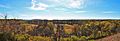
Pepin County panorama, west of Durand
See also
 In Spanish: Condado de Pepin para niños
